This item has been sold, but you can get on the Waitlist to be notified if another example becomes available, or purchase a digital scan.
1795 D'Anville Wall Map of South America
SouthAmerica-laruiewhittle-1794$1,250.00

Title
A Map of South America containing Tierra-Firma, Guayana, New Granada, Amazonia, Brasil, Peru, Paraguay, Chaco, Tucuman, Chili and Patagonia from M. d'Anville with Several Imporvements and Additions, and The Newest Discoveries.
1794 (dated) 39 x 46 in (99.06 x 116.84 cm)
1794 (dated) 39 x 46 in (99.06 x 116.84 cm)
Description
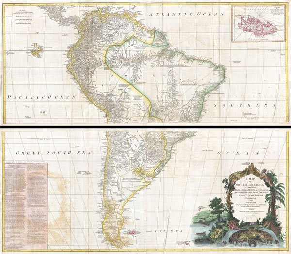
This is probably the most important two panel wall map of South America produced in the 18th century. Largely based upon the earlier D'Anville map, this map has been enlarged and expanded by the English publishing house of Laurie and Whittle. Depicts the continent in full with an inset of the Falkland Islands. This map is unique in that it is a serious attempt to compile all of the accurate scientific knowledge of the South American continent available at the time. Offers a smorgasbord of factual, speculative, and historical detail.
This extraordinary and highly decorative map bears up to almost endless perusal and volumes could be composed upon its content. The cartographer attempts to depict both known and unknown parts of the continent with actual data reported by both contemporary and historic travelers. In most cases it is extremely difficult to identify specific sources as much of the data is vague and uncertain.
Our survey of this map beings with the coast which Spanish and Portuguese navigators had mapped with considerable accuracy as early as the late 16th century. This, like most early maps of the area, contrasts a detailed mapping of the coast with a speculative discussion of the interior, particularly Patagonia and the Amazon Basin. Offers a fairly accurate discussion of both the east and west coasts with exceptional detail in the populated Andean regions of Venezuela, Columbia, Ecuador (Labeled Quito), and Peru. Notes Cuzco, Lima, Quito, Valladolid, Arequipa, Trujillo and other important trading centers of the region. In Portuguese controlled Brazil, Rio de Janeiro, San Salvador and San Sebastian are noted.
It is in the interior that this map becomes exceptionally fascinating. In the northern part of the continent D'Anville maps a number of confusions associated with the English adventurer Sir Walter Raleigh's search for El Dorado. Believing El Dorado to lie in the northern part of the Amazon, Raleigh sailed down the Orinoco River just before the onset of the rainy season. Reaching a remote tribal village, Raleigh noted canoes arriving bearing gold, silver, and other treasures. Asked where the gold came from, the natives replied, 'Manoa,' the term for the tribe to which the river traders belonged. Manoa, the natives claimed could be reached following a long river voyage southward to a Great Lake, called Parima. Raleigh and his associates immediately associated Manoa and Lake Parima with the golden kingdom of El Dorado, though they never visited the city or lake. Subsequent maps, including this one, mapped El Dorado and Lake Parima in this location for several hundred years. Both Raleigh and the natives were describing an actual event known to occur annually in the region. Rains would annually swell the Amazon and Orinoco river systems creating a linkage in the Parima flood plain, which, during heavy rains, can resemble a massive lake. The Manoa were a large and populous trading nation active pre-colonial days whose vast empire, based in the Amazon Basin, extended form the Andes to the Orinoco. Curiously, in addition to noting the city of Manoa on Lake Parima, D'Anville also correctly maps the center of the ancient Manoan civilization between the Amazon tributaries Rio Negro and Rio Yapura. Sadly the Manoa and many of the other populous South American indigenous nations noted by the earliest explores to the region vanished, brought low by European epidemics.
A similar error appears far to the south where the Paraguay rivers empties into the Laguna de Xarayes. The Xarayes, a corruption of 'Xaraiés' meaning 'Masters of the River,' were an indigenous people occupying what are today parts of Brazil's Matte Grosso and the Pantanal. When Spanish and Portuguese explorers first navigated up the Paraguay River, as always in search of El Dorado, they encountered the vast Pantanal flood plain at the height of its annual inundation. Understandably misinterpreting the flood plain as a gigantic inland sea, they named it after the local inhabitants, the Xaraies. The Laguna de los Xarayes almost immediately began to appear on early maps of the region and, at the same time, almost immediately took on a legendary aspect. Later missionaries and chroniclers, particularly Díaz de Guzmán, imagined an island in this lake and curiously identified it as an 'Island of Paradise,'
Far to the south Patagonia is crisscrossed with a number of speculative rivers based upon assumptions from earlier cartographers. D'Anville notes several questionable river passes that suggest a possible navigable communication between the east and west coasts of the continent. Speculation on such a pass fueled the famous South Sea Company, one of the modern world's first stock bubbles, but when no such pass was discovered, the bubble burst.
D'Anville also notes several offshore discoveries including the Galapagos, which he calls the Inchanted Islands, the Isle of Georgia, the Juan Fernandez islands, the Falkands, and some curious land masses just west of the Galapagos labeled 'Isles known to the Spanish.' Curiously, he also notes a 'a Bank of Sounding Discovered by Capt. Hook in 1767.' We know of no navigator by the name of Captain Hook except Peter Pan's fictional nemesis. Most likely this is a misprinted reference to Captain Cook, who was active in the Atlantic at this time. One can only wonder if J.M. Barrie had this map handy when imagining his fictional villain.
Prepared from work by D'Anville and published by Laurie & Whittle in Kitchin's 1794 General Atlas.
This extraordinary and highly decorative map bears up to almost endless perusal and volumes could be composed upon its content. The cartographer attempts to depict both known and unknown parts of the continent with actual data reported by both contemporary and historic travelers. In most cases it is extremely difficult to identify specific sources as much of the data is vague and uncertain.
Our survey of this map beings with the coast which Spanish and Portuguese navigators had mapped with considerable accuracy as early as the late 16th century. This, like most early maps of the area, contrasts a detailed mapping of the coast with a speculative discussion of the interior, particularly Patagonia and the Amazon Basin. Offers a fairly accurate discussion of both the east and west coasts with exceptional detail in the populated Andean regions of Venezuela, Columbia, Ecuador (Labeled Quito), and Peru. Notes Cuzco, Lima, Quito, Valladolid, Arequipa, Trujillo and other important trading centers of the region. In Portuguese controlled Brazil, Rio de Janeiro, San Salvador and San Sebastian are noted.
It is in the interior that this map becomes exceptionally fascinating. In the northern part of the continent D'Anville maps a number of confusions associated with the English adventurer Sir Walter Raleigh's search for El Dorado. Believing El Dorado to lie in the northern part of the Amazon, Raleigh sailed down the Orinoco River just before the onset of the rainy season. Reaching a remote tribal village, Raleigh noted canoes arriving bearing gold, silver, and other treasures. Asked where the gold came from, the natives replied, 'Manoa,' the term for the tribe to which the river traders belonged. Manoa, the natives claimed could be reached following a long river voyage southward to a Great Lake, called Parima. Raleigh and his associates immediately associated Manoa and Lake Parima with the golden kingdom of El Dorado, though they never visited the city or lake. Subsequent maps, including this one, mapped El Dorado and Lake Parima in this location for several hundred years. Both Raleigh and the natives were describing an actual event known to occur annually in the region. Rains would annually swell the Amazon and Orinoco river systems creating a linkage in the Parima flood plain, which, during heavy rains, can resemble a massive lake. The Manoa were a large and populous trading nation active pre-colonial days whose vast empire, based in the Amazon Basin, extended form the Andes to the Orinoco. Curiously, in addition to noting the city of Manoa on Lake Parima, D'Anville also correctly maps the center of the ancient Manoan civilization between the Amazon tributaries Rio Negro and Rio Yapura. Sadly the Manoa and many of the other populous South American indigenous nations noted by the earliest explores to the region vanished, brought low by European epidemics.
A similar error appears far to the south where the Paraguay rivers empties into the Laguna de Xarayes. The Xarayes, a corruption of 'Xaraiés' meaning 'Masters of the River,' were an indigenous people occupying what are today parts of Brazil's Matte Grosso and the Pantanal. When Spanish and Portuguese explorers first navigated up the Paraguay River, as always in search of El Dorado, they encountered the vast Pantanal flood plain at the height of its annual inundation. Understandably misinterpreting the flood plain as a gigantic inland sea, they named it after the local inhabitants, the Xaraies. The Laguna de los Xarayes almost immediately began to appear on early maps of the region and, at the same time, almost immediately took on a legendary aspect. Later missionaries and chroniclers, particularly Díaz de Guzmán, imagined an island in this lake and curiously identified it as an 'Island of Paradise,'
...an island [of the Paraguay River] more than ten leagues [56 km] long, two or three [11-16 km] wide. A very mild land rich in a thousand types of wild fruit, among them grapes, pears and olives: the Indians created plantations throughout, and throughout the year sow and reap with no difference in winter or summer, ... the Indians of that island are of good will and are friends to the Spaniards; Orejón they call them, and they have their ears pierced with wheels of wood ... which occupy the entire hole. They live in round houses, not as a village, but each apart though keep up with each other in much peace and friendship. They called of old this island Land of Paradise for its abundance and wonderful qualities.To the north of the 'Island of Paradise' appeared the 'Puerto de los Reyes' which was considered to be a gateway to the Amazon and the Kingdom of El Dorado. D'Anville, to his credit, shows the 'Laguna' and it's island in a much reduced form compared to earlier cartographers and also comments that its existence is 'dubious.'
Far to the south Patagonia is crisscrossed with a number of speculative rivers based upon assumptions from earlier cartographers. D'Anville notes several questionable river passes that suggest a possible navigable communication between the east and west coasts of the continent. Speculation on such a pass fueled the famous South Sea Company, one of the modern world's first stock bubbles, but when no such pass was discovered, the bubble burst.
D'Anville also notes several offshore discoveries including the Galapagos, which he calls the Inchanted Islands, the Isle of Georgia, the Juan Fernandez islands, the Falkands, and some curious land masses just west of the Galapagos labeled 'Isles known to the Spanish.' Curiously, he also notes a 'a Bank of Sounding Discovered by Capt. Hook in 1767.' We know of no navigator by the name of Captain Hook except Peter Pan's fictional nemesis. Most likely this is a misprinted reference to Captain Cook, who was active in the Atlantic at this time. One can only wonder if J.M. Barrie had this map handy when imagining his fictional villain.
Prepared from work by D'Anville and published by Laurie & Whittle in Kitchin's 1794 General Atlas.
CartographerS
Jean Baptiste Bourguignon d'Anville (1697 - 1782) was perhaps the most important and prolific cartographer of the 18th century. D'Anville's passion for cartography manifested during his school years when he amused himself by composing maps for Latin texts. There is a preserved manuscript dating to 1712, Graecia Vetus, which may be his earliest surviving map - he was only 15 when he drew it. He would retain an interest in the cartography of antiquity throughout his long career and published numerous atlases to focusing on the ancient world. At twenty-two D'Anville, sponsored by the Duke of Orleans, was appointed Geographer to the King of France. As both a cartographer and a geographer, he instituted a reform in the general practice of cartography. Unlike most period cartographers, D'Anville did not rely exclusively on earlier maps to inform his work, rather he based his maps on intense study and research. His maps were thus the most accurate and comprehensive of his period - truly the first modern maps. Thomas Basset and Philip Porter write: "It was because of D'Anville's resolve to depict only those features which could be proven to be true that his maps are often said to represent a scientific reformation in cartography." (The Journal of African History, Vol. 32, No. 3 (1991), pp. 367-413). In 1754, when D'Anville turned 57 and had reached the height of his career, he was elected to the Academie des Inscriptions. Later, at 76, following the death of Philippe Buache, D'Anville was appointed to both of the coveted positions Buache held: Premier Geographe du Roi, and Adjoint-Geographer of the Academie des Sciences. During his long career D'Anville published some 211 maps as well as 78 treatises on geography. D'Anville's vast reference library, consisting of over 9000 volumes, was acquired by the French government in 1779 and became the basis of the Depot Geographique - though D'Anville retained physical possession his death in 1782. Remarkably almost all of D'Anville's maps were produced by his own hand. His published maps, most of which were engraved by Guillaume de la Haye, are known to be near exact reproductions of D'Anville' manuscripts. The borders as well as the decorative cartouche work present on many of his maps were produced by his brother Hubert-Francois Bourguignon Gravelot. The work of D'Anville thus marked a transitional point in the history of cartography and opened the way to the maps of English cartographers Cary, Thomson and Pinkerton in the early 19th century. More by this mapmaker...
Laurie and Whittle (fl. 1794 - 1858) were London, England, based map and atlas publishers active in the late 18th and early 19th century. Generally considered to be the successors to the Robert Sayer firm, Laurie and Whittle was founded by Robert Laurie (c. 1755 - 1836) and James Whittle (1757-1818). Robert Laurie was a skilled mezzotint engraver and is known to have worked with Robert Sayer on numerous projects. James Whittle was a well-known London socialite and print seller whose Fleet Street shop was a popular haunt for intellectual luminaries. The partnership began taking over the general management of Sayer's firm around 1787; however, they did not alter the Sayer imprint until after Sayer's death in 1794. Apparently Laurie did most of the work in managing the firm and hence his name appeared first in the "Laurie and Whittle" imprint. Together Laurie and Whittle published numerous maps and atlases, often bringing in other important cartographers of the day, including Kitchin, Faden, Jefferys and others to update and modify their existing Sayer plates. Robert Laurie retired in 1812, leaving the day to day management of the firm to his son, Richard Holmes Laurie (1777 - 1858). Under R. H. Laurie and James Whittle, the firm renamed itself "Whittle and Laurie". Whittle himself died six years later in 1818, and thereafter the firm continued under the imprint of "R. H. Laurie". After R. H. Laurie's death the publishing house and its printing stock came under control of Alexander George Findlay, who had long been associated with Laurie and Whittle. Since, Laurie and Whittle has passed through numerous permeations, with part of the firm still extant as an English publisher of maritime or nautical charts, 'Imray, Laurie, Norie and Wilson Ltd.' The firm remains the oldest surviving chart publisher in Europe. Learn More...
Thomas Kitchin (August 4, 1718 – June 23, 1784) was a London based engraver, cartographer, and publisher. He was born in London to a hat-dyer of the same name. At 14, Kitchin apprenticed under Emanuel Bowen, under whom he mastered the art of engraving. He married Bowen daughter, Sarah Bowen, and later inherited much of his preceptor's prosperous business. Their son, Thomas Bowen Kitchin, also an engraver joined the family business, which thereafter published in Thomas Kitchin and Son. From 1858 or so Kitchin was the engraver to the Duke of York, and from about 1773 acquired the title, 'Royal Hydrographer to King George III.' He is responsible for numerous maps published in the The Star, Gentleman's Magazine, and London Magazine, as well as partnering with, at various times, with Thomas Jefferys, Emmanuel Bowen, Thomas Hinton, Issac Tayor, Andrew Dury, John Rocque, Louis de la Rochette, and Alexander Hogg, among others. Kitchin passed his business on to his son, Thomas Bowen Kitchin, who continued to republish many of his maps well after his death. Kitchin's apprentices included George Rollos, Bryant Lodge, Thomas Bowen Kitchin, Samuel Turner Sparrow, John Page, and Francis Vivares. Learn More...
Source
Kitchin, Thomas, Kitchin's General Atlas, describing the Whole Universe: being a complete collection of the most approved maps extant; corrected with the greatest care, and augmented from the last edition of D'Anville and Robert with many improvements by other eminent geographers, engraved on Sixty-Two plates, comprising Thirty Seven maps., Laurie & Whittle, London, 1797.
Condition
Very good condition. Light offsetting. Blank on verso. Printed on four sheets, top two and bottom two joined by publisher. This map is thus currently in two separate panels - as issued. It can be framed very dramatically in two separate, tightly spaced panels, or joined at the buyer's request into a single impressive sheet. Size reflects both maps, joined.
References
Rumsey 2310.091, 2310.090 2310.089. Phillips (Atlases), 4300, 6008-36-37. Bancroft Library G5200 1794.A5. Shirley, R., Maps in the atlases of the British Library, T.LAU-1c (1799 ed.). National Maritime Museum, 375 (3rd ed. 1801).