This item has been sold, but you can get on the Waitlist to be notified if another example becomes available, or purchase a digital scan.
1765 Isaak Tirion Map of South America
SouthAmerica-tirion-1765$150.00

Title
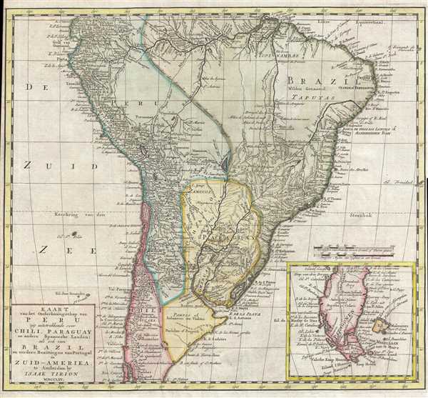
Kaart van het Onderkoningschap van Peru zig uitstrekkende over Chili, Paraguay en andere Spaansche Landen : als ook van Brazil en verdere Bezittingen van Portugal in Zuid-Amerika.
1765 (dated) 14.25 x 15.75 in (36.195 x 40.005 cm) 1 : 15000000
1765 (dated) 14.25 x 15.75 in (36.195 x 40.005 cm) 1 : 15000000
Description
This is a 1765 Isaak Tirion map of South America. The map depicts the continent from the Equator to Tierra del Fuego and from the Pacific Ocean to the Atlantic Ocean. Divided into several regions, a certain amount of political and colonial divisions are illustrated. Highly detailed, myriad locations are identified throughout, including cities, towns, tribal regions, points along the coast, and more. Some of the labeled cities include Quito, Guayaquil, Lima, Asuncion, and Buenos Aires. Numerous rivers, including the Amazon and the Paraguay, are labeled, as are the Andes Mountains. An inset map in the lower right corner depicts the tip of South America, Tierra del Fuego, and Cape Horn.
Perhaps the most interesting element of this map is the representation of the apocryphal Lake of Xarayes at the northern terminus of the Paraguay River. 'Xarayes' is a corruption of 'Xaraies' meaning 'Masters of the River.' The Xaraies were an indigenous people occupying what are today parts of Brazil's Matte Grosso and the Pantanal. When Spanish and Portuguese explorers first navigated up the Paraguay River, as always in search of El Dorado, they encountered the vast Pantanal flood plain at the height of its annual inundation. Understandably misinterpreting the flood plain as a gigantic inland sea, they named it after the local inhabitants, the Xaraies. The Laguna de los Xarayes almost immediately began to appear on early maps of the region and, at the same time, almost immediately took on a legendary aspect as the gateway to El Dorado.
This map was created by Isaak Tirion in 1765.
Cartographer
Isaak Tirion (1705 - 1765) was a Dutch publisher in Amsterdam. Born in Utrecht, Tirion quickly rose to prominence by publishing pamphlets, historical works, and most importantly, maps and atlases. He produced several atlases and Dutch town plans. His maps are mainly based on those of Guillaume de l'Isle. Tirion eventually relocated his printing house to the prestigious Kalverstraat. In his long career, he produced eight atlases in multiple editions, some of which were published posthumously until about 1784. More by this mapmaker...
Condition
Very good. Light wear along original fold lines. Very small margins along both sides. Blank on verso.
References
OCLC 71396885.