1838 Bradford Map of South Carolina
SouthCarolina-bradford-1838$350.00

Title
South Carolina.
1838 (dated) 12 x 15.5 in (30.48 x 39.37 cm) 1 : 1267200
1838 (dated) 12 x 15.5 in (30.48 x 39.37 cm) 1 : 1267200
Description
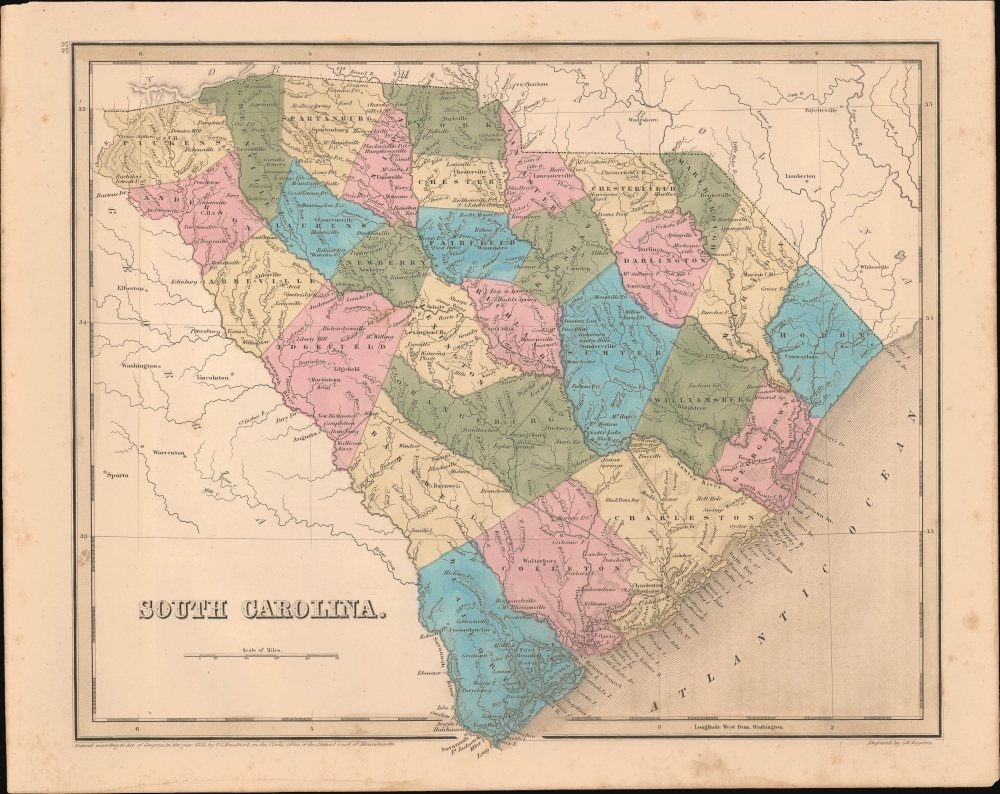
This is an 1838 Thomas G. Bradford map of South Carolina.
A Closer Look
The map embraces all of South Carolina as well as significant parts of adjacent Georgia and North Carolina. It includes a fledgling railroad network extending from Charleston inland in two branches as far as Hamburg and Columbia.Historical Context - Slavery
In 1838, South Carolina was a tumultuous place both politically and socially. As a cornerstone of the antebellum South, the state was deeply rooted in an agrarian economy dependent on enslaved labor. Cotton production thrived, bolstered by the labor of thousands of enslaved Africans, making plantation owners among the wealthiest in the nation. The state was also at the forefront of states' rights debates, having recently emerged from the Nullification Crisis of the early 1830s. This episode, during which South Carolina attempted to nullify federal tariffs, highlighted the growing tensions between the state and the federal government - a discord that would intensify in the years leading up to the American Civil War.h6>Publication History and CensusThis map was engraved by George Boynton in 1838 and published in the 1841 edition of Bradford and Goodrich's A Universal Illustrated Atlas. The map received regular updates through the late 1840s.CartographerS
Thomas Gamaliel Bradford (1802 - 1887) was born in Boston, Massachusetts, where he worked as an assistant editor for the Encyclopedia Americana. Bradford's first major cartographic work was his revision and subsequent republishing of an important French geography by Adrian Balbi, Abrege de Geographie published in America as Atlas Designed to Illustrate the Abridgment of Universal Geography, Modern and Ancient. Afterwards Bradford revised and expanded this work into his own important contributions to American cartography, the 1838 An Illustrated Atlas Geographical, Statistical and Historical of the United States and Adjacent Countries. Bradford's cartographic work is significant as among the first to record Texas as an independent nation. In his long career as a map publisher Bradford worked with William Davis Ticknor of Boston, Freeman Hunt of New York, Charles De Silver of Philadelphia, John Hinton, George Washington Boynton, and others. We have been able to discover little of Bradford's personal life. More by this mapmaker...
George Washington Boynton (fl. c. 1830 - 1850) was a Boston based cartographer and map engraver active in the first half of the 19th century. Boynton engraved and compiled maps for numerous publishers including Thomas Bradford, Nathaniel Dearborn, Daniel Adams, and S. G. Goodrich. His most significant work is most likely his engraving of various maps for Bradford's Illustrated Atlas, Geographical, Statistical, and Historical, of the United States and the Adjacent Countries and Universal Illustrated Atlas. He also engraved for the Boston Almanac. In 1835, Boynton is listed as an employee of the Boston Bewick Company, an engraving, stereotype, and printing concern based at no. 47 Court Street, Boston. Little else is known of his life. Learn More...
Source
Bradford, T. G. and Goodrich, S. G., A Universal Illustrated Atlas, exhibiting a Geographical, Statistical, and Historical view of the World, (Boston: Charles D. Strong) 1841.
The Universal Illustrated Atlas is one of the great American atlases of the first half of the 19th century. The atlas was first published in 1838 under the imprint of Charles D. Strong. It replaced and superseded Bradford's earlier smaller format Illustrated Atlas, Geographical, Statistical, and Historical, of the United States and the Adjacent Countries. Numerous reissues of the Universal Illustrated Atlas followed until about 1848. Although there are minor variations between the editions, most contain about 50 maps, the majority of which focus on the United States. Bradford's atlases are significant for recording North America during the Republic of Texas Era. In later editions, particularly the 1846 edition, Bradford illustrates the boom in railroad construction, possibly with the idea that his maps would aid travelers in planning journeys by rail. It was compiled by Thomas Gamaliel Bradford and Samuel Griswold Goodrich with most of the plates engraved by George Washington Boynton (fl. c. 1830 - 1850). Other contributors include Thomas Gordon (1778 - 1848), Fielding Lucas Jr. (1781 - 1854), Samuel Edward Stiles (1844 - 1901), Sherman and Smith (fl. c. 1829 - 1855), and Horace Thayer (1811 - c. 1874).
Condition
Very good. Even overall toning.
References
Rumsey 4453.031.