1984 Asian Oil and Gas Map of Reserves in the South China Sea
SouthChinaSea-asianoilandgas-1984$400.00


Title
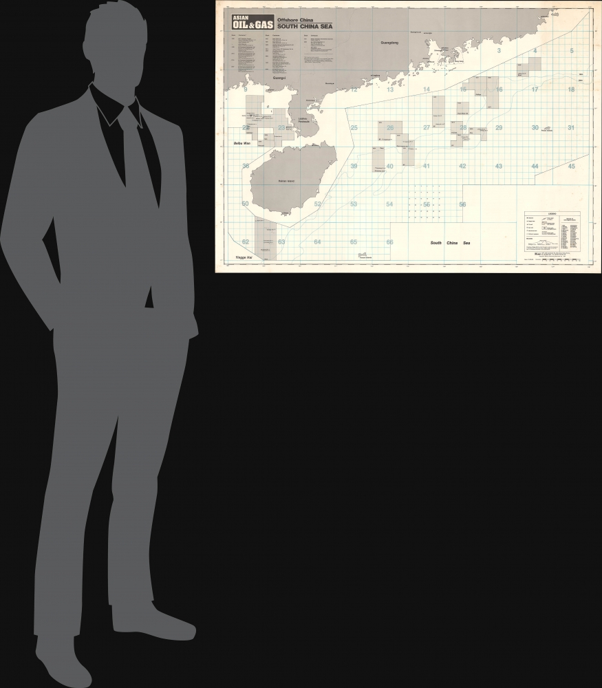
Offshore China South China Sea.
1984 (dated) 29.5 x 37.5 in (74.93 x 95.25 cm) 1 : 1000000
1984 (dated) 29.5 x 37.5 in (74.93 x 95.25 cm) 1 : 1000000
Description
This is a 1984 map of offshore oil and gas fields in the South China Sea, prepared for the publication Asian Oil and Gas.
A Closer Look
Coverage extends, along the coast, from eastern Guangdong (Shantou, formerly known in Western sources as Swatow) to Beihai (formerly Pakhoi in Western sources), intersected by the Leizhou Peninsula and Hainan Island. Cities, provinces, and other features are noted on land. On the water, the depth of the ocean floor is indicated, while the surface is divided into a grid, separated into 'one-degree' (latitude and longitude) blocks, which are themselves subdivided into '10-minute' blocks. Various features are noted according to the legend at bottom-right, including wells, platforms, and oilfields. Areas under contract with oil companies, mostly foreign (British, American, Japanese), though also some from Hong Kong (Pearl River Oil) or even Mainland China (Huanan).Territorial Disputes and Hydrocarbons
The Paracel Islands, disputed between China and Vietnam but controlled by China since a 1974 battle with military forces of the faltering South Vietnamese government, is noted at bottom. Known in Chinese as Xisha and in Vietnamese as Hoàng Sa, the islands are located near what are likely considerable oil and gas reserves. These have not been sufficiently explored or exploited due to the ongoing dispute, including a 2014 collision of Vietnamese and Chinese ships when the Chinese attempted to establish an oil rig in the region.Publication History and Census
This map was prepared and published by Asian Oil and Gas, a specialized journal published in Hong Kong, in 1984. It is only independently cataloged at the Institute of Southeast Asian Studies - Yusof Ishak Institute in Singapore, while physical examples of the journal (OCLC 20157167) are held by about fourteen institutions worldwide, with no certainty over the extent of the collection at each. This map is part of a pair or perhaps a series prepared by the journal, titled 'Offshore China,' the Yellow Sea sheet of which is also offered by us (OffshoreChina-asianoilandgas-1985).Condition
Very good. Closed tear extending 1.75 inches into printed area from right margin professionally repaired on verso.
References
OCLC 1223365138.