This item has been sold, but you can get on the Waitlist to be notified if another example becomes available, or purchase a digital scan.
1763 Van Keulen 'Secret Atlas' Map of Singapore, Malacca, Cambodia, Borneo
SouthChinaSea-keulen-1753$14,000.00

Title
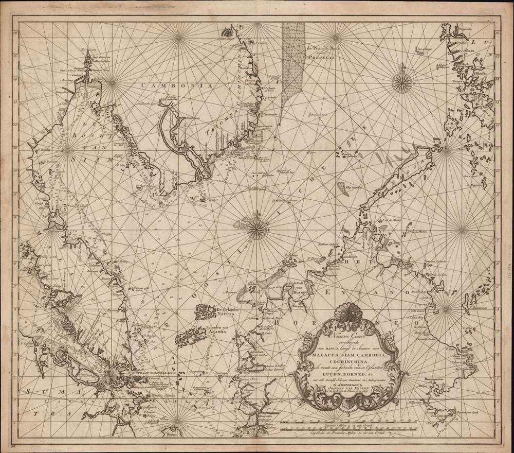
Nieuwe Caart strekkende van Banca, langs de kusten van Malacca, Siam, Cambodia, Cochinchina, als meede een gedeelte van de Eylanden Luçon, Borneo, et c. met alle dresslss Havens, Dieptens en Ankergronden.
1753 (undated) 21 x 24 in (53.34 x 60.96 cm) 1 : 4100000
1753 (undated) 21 x 24 in (53.34 x 60.96 cm) 1 : 4100000
Description
The rare 1753 Johannes II van Keulen / Jan de Marre nautical map of the South China Sea compiled for the sixth volume of the Zee-Fakkel - the legendary Dutch East India Company (VOC - Vereenigde Oostindische Compagnie) 'Secret Atlas.' The map covers the South China Sea and Gulf of Thailand - thus embracing Singapore, Malaya, southern Thailand (Siam), Cambodia, southern Vietnam, most of Borneo, and parts of the Philippines. The map illustrates the most important waters and most dangerous sea passages in the East Indies. It was an essential navigational reference for VOC ships sailing from Malacca, through the Straits of Singapore, or north from Batavia for Siam (Bangkok), Laauwec (Cambodia), Nagasaki, Canton (Guangzhou), Macao, or Manila.
Most notably, van Keulen highlights coast-hugging routes into the Gulf of Thailand to the mouth of the Chao Phraya, thus providing access to Bangkok and Lopburi. This would have been an important supply route for the VOC settlement in Batavia. Depending on the political situation, the VOC relied on either Siam or Cambodia for supplies.
This was likely an attempt to consolidate and improve the general hydrography. Previously, VOC charts in manuscript were disseminated to ship captains on an as-needed basis, to be returned upon a voyage's completion. A study of several VOC manuscript charts issued between 1720 and 1760 reveal striking disparities, likely resulting either from the charts being updated or copied from earlier less accurate charts. These differences led to avoidable navigational errors and the accompanying trade risks. A printed nautical atlas, whose hydrography was built upon the most up-to-date charts reassessed by the greatest chartmaker of the age, was a natural solution.
The new atlas was designed from VOC manuscript material collated and reassessed by Jan de Marre and van Keulen. Ostensibly it was an extension (Volume VI) of the existing commercially issued Nieuwe Lichtende Zee-Fakkel. However, it was intended only for VOC use, and thus became known as the 'Secret Atlas'. The printing run was extremely small, and access tightly controlled. VOC ship captains navigating to the Far East were given a copy on departure and expected to return it in good condition. Even so, the maps of the 'Secret Atlas' were disseminated, perhaps by the van Keulen's themselves. We note evidence of 'secret' Dutch hydrography in charts of the English Pilot as well as in other Dutch charts. Nonetheless, original maps from the 'Secret' Zee-Fakkel Volume VI remain of the utmost rarity.
A Closer Look
Coverage embraces the primary trade centers of the South China Sea - reaching form the island of Penang (Pinang) west of Malay (Malacca) to Manila in the Philippines, and from roughly Bangkok (Siam) and Danang (near Taisoe here), to eastern Borneo. The island of Singapore is named (Singapoera), as is the Jahor River (Djohor). The Philippines are included sufficiently to highlight the approaches to Manila, with southwestern Luzon (Lucon), Mindoro (Mindora), and Palawan (Paragoa) depicted. In Borneo, the centers of 'Borneo' (likely modern-day Brunei), Caburo, and Bancamanican are noted.Trading and Supply Centers in Siam and Cambodia
Inland, the map follows the Chao Phraya River north beyond Bangkok to the Lopburi (Louveau) where the VOC maintained a factory. Likewise, it follows the Sông Hâu and Mekong Rivers in Cambodia north as far as 'De Stad Cambodia', likely Laauweck (Lawec), the on-and-off capital of Cambodia where the VOC set up a trading depot.Most notably, van Keulen highlights coast-hugging routes into the Gulf of Thailand to the mouth of the Chao Phraya, thus providing access to Bangkok and Lopburi. This would have been an important supply route for the VOC settlement in Batavia. Depending on the political situation, the VOC relied on either Siam or Cambodia for supplies.
The Secret Atlas
Much has been made of the so-called VOC 'Secret Atlas'. In 1753, Johannes II van Keulen (1704 - 1755) produced a revolutionary expansion of his grandfather's Zee-Fakkel. Published as Volume VI, the atlas was the first van Keulen publication to focus on Asian waters. For three generations the Van Keulen's were the official cartographers of the VOC. To protect their long-standing trade monopoly, the VOC jealously guarded hydrographic data on East Asian waters, refusing to allow charts to be printed and requiring oaths of secrecy from the Van Keulens (and Bleaus before them). By 1753, already in decline, the VOC began to loosen their stranglehold on cartographic knowledge, allowing Johannes II to compile and publish charts of Asian waters, BUT only for internal VOC use.This was likely an attempt to consolidate and improve the general hydrography. Previously, VOC charts in manuscript were disseminated to ship captains on an as-needed basis, to be returned upon a voyage's completion. A study of several VOC manuscript charts issued between 1720 and 1760 reveal striking disparities, likely resulting either from the charts being updated or copied from earlier less accurate charts. These differences led to avoidable navigational errors and the accompanying trade risks. A printed nautical atlas, whose hydrography was built upon the most up-to-date charts reassessed by the greatest chartmaker of the age, was a natural solution.
The new atlas was designed from VOC manuscript material collated and reassessed by Jan de Marre and van Keulen. Ostensibly it was an extension (Volume VI) of the existing commercially issued Nieuwe Lichtende Zee-Fakkel. However, it was intended only for VOC use, and thus became known as the 'Secret Atlas'. The printing run was extremely small, and access tightly controlled. VOC ship captains navigating to the Far East were given a copy on departure and expected to return it in good condition. Even so, the maps of the 'Secret Atlas' were disseminated, perhaps by the van Keulen's themselves. We note evidence of 'secret' Dutch hydrography in charts of the English Pilot as well as in other Dutch charts. Nonetheless, original maps from the 'Secret' Zee-Fakkel Volume VI remain of the utmost rarity.
Publication History and Census
This map was engraved and published in 1753 by Johannes II van Keulen for inclusion in the sixth volume of the Nieuwe Lichtende Zee-Fakkel, the so-called 'Secret Atlas of the VOC'. It appeared in only one state and was never distributed publicly, thus all examples are exceedingly scarce. We note just 3 examples of this map known, all associated with institutional holdings of the original atlas. The Zee-Fakkel was reissued in facsimile in the 1970s, with the 500 copies largely held by institutions - which makes it near impossible to trace holdings of the original 1753 edition. We have confidentially identified just 3 holdings.CartographerS
Johannes Van Keulen (1654 – 1715) was a Dutch cartographer active in Amsterdam during the late 17th century. Van Keulen was the son of Lucas van Keulen. Van Keulen's firm, ‘In de Gekroonde Lootsman' (In the Crowned Pilot), was founded in 1678 and registered with the Amsterdam bookseller's guild as 'Cross staff-maker and bookseller.' (The cross-staff is a nautical instrument used to determine latitude.) Two years later, in 1680, they obtained a patent from the States General of Holland and West Friesland to publish nautical charts and atlases. Together with his partner, the cartographer Claes Janz Vooght, Van Keulen published numerous atlases and nautical charts, including the Zee Atlas and Nieuwe Lichtende Zee-Fakkel. It was a massive five-volume atlas containing more than 130 nautical charts. The Zee-Fakkel established the Van Keulen firm as the pre-eminent maker of Dutch sea charts in the late 17th and early 18th century. In 1714, one year before Johannes Van Keulen's death, his son, Gerard van Keulen (1678 - 1726), took charge. Gerard continued to update and republish the Zee-Fakkel until his own death in 1726. The firm was later passed on to Gerard's son, Johannes II Van Keulen (1704 - 1755), who significantly updated the atlas, especially with regard to Asia, issuing the 1753 4th Volume, known as the 'Secret Atlas'. The final editions of the atlas were published by Gerard Hulst van Keulen (1733 - 1801), Joannes II's son. The final true Van Keulen edition of the Zee-Fakkel was published posthumously in 1803. It is noteworthy that though ostensibly controlled by the Van Keulen men, it was the Van Keulen widows who maintained and managed the firm in the periods following their husbands' deaths. After the death of Gerard Hulst Van Keulen's son, Johannes Hulst Van Keulen, ownership of the family plates and business fell into the hands of the Swart family, who continued to publish until the company closed its doors 1885, ending a cartographic legacy spanning nearly 207 years. More by this mapmaker...
Johannes II van Keulen (1704 - 1755) was a Dutch map publisher, engraver, chartmaker, and instrument seller active in Amsterdam in the first half of the 19th century. He is a scion of the significant van Keulen publishing dynasty and, after his grandfather of the same name (1654 - 1715), the most important figure in that family's long publishing history. Johannes II's father was Gerard van Keulen (1678 - 1726). Like his father and grandfather, Johannes II was appointed hydrographer to the VOC (Vereenigde Oostindische Compagnie / United Dutch East India Company), inheriting the position on his father's 1726 death. He was elevated to chief VOC cartographer in 1743. In the next year, 1744, Jan Harmenszoon de Marre (1696 - 1763), Examiner of the Amsterdam Chamber of the VOC, was ordered to work with Johannes II to compile a new volume of the trademark van Keulen Zee-Fakkel, based upon manuscript nautical charts of the East Indies and East Asia long kept secret by the VOC. This work, published in 1753 as volume 6 of the Zee-Fakkel, was the first printing of the VOC's most tightly guarded secrets. The work was not intended for public sale, rather, it was meant to consolidate and improve upon the older, often contradictory, VOC manuscript charts. It became known as the 'Secret Atlas', as its use was restricted to VOC pilots who were issued the volume at the outset of a voyage, and expected to surrender it on the return. Although any VOC official, including van Keulen, with access to the atlas was placed under bonds of secrecy, data did eventually leak. Many of the maps, superior to anything previously obtainable, laid the foundation for subsequent charts published by English, French, and other Dutch cartographers. When Johannes II died, the business passed to his son, Gerard Hulst van Keulen (1733 - 1801). Learn More...
Jan Harmenszoon de Marre (August 23, 1696 - January 19, 1763) was a Dutch navigator, writer, and VOC agent active in the 18th century. De Marre was born in Amsterdam. While he received limited schooling, he associated himself from 1708, at age 12, with the United East India Company (VOC). He spent 23 years with the VOC, rising to ship captain, and vice-admiral. When he retiruned from active voyaging, the became the Examiner of the Amsterdam Chamber of the East Indies Company. In 1744, he was instructed to help Johannes II van Keulen (1704 - 1755) compile and construct secret VOC nautical charts of the East Indies into a new sixth volume of the Zee-Fakkel, which was published in 1753 - the first-time secret VOC hydrography saw print. Although his contribution to cartography was groundbreaking, de Marre is better known as a playwright and poet, his most famous works being Eerkroon voor de Caab de Goede Hoop, Batavia, and Jacoba van Beieren. He died in Amsterdam in 1763. Learn More...
Source
Keulen, J. van, Nieuwe Lichtende Zee-Fakkel, Part VI (Amsterdam) 1753.
Nieuwe Lichtende Zee-Fakkel was the premier Dutch nautical atlas of the late 17th and 18th century. First introduced in 1681, over the course of its more than 100 years in production, the Zee-Fakkel expanded to six volumes. The first five volumes were published in Amsterdam by Johannes van Keulen (1654 - 1715). His son, Gerard van Keulen (1678 - 1726), reissued it in several editions with minor updates.
Grandson, Johannes II van Keulen (1704 - 1755) expanded the atlas in 1753 with Volume VI, illustrating Asian waters. This was a revolutionary addition. For three generations the Van Keulen's were the official cartographers of the VOC (Vereenigde Oostindische Compagnie / United Dutch East India Company). Until 1753, to protect their long-standing trade monopoly, the VOC jealously guarded their hydrographic data on East Asian waters, refusing the allow charts to be printed and requiring oaths of secrecy from the Van Keulens (and Bleaus before them). This led to dangerously inaccurate often contradictory charts. Thus, in 1744 Jan Harmenszoon de Marre (1696 - 1763), the VOC's Amsterdam Examiner, was instructed to work with van Keulen to publish compile, compare, and resolve the VOC's hoard of jealously guarded manuscript charts of East Asian waters. Johannes II and de Marre published the sixth volume of the Zee-Fakkel, focusing on Asian waters - if only for internal VOC use.
This was likely an attempt to consolidate and improve the general hydrography. Previously, VOC charts in manuscript were disseminated to ship captains on an as-needed basis, to be returned upon a voyage's completion. They were rarely compared or amended. A study of several VOC manuscript charts issued between 1720 and 1760 reveal striking disparities, likely resulting either from the charts being updated or copied from earlier less accurate charts. Such led to avoidable navigational and thus trade risks. A printed nautical atlas, whose hydrography was built upon the most recent and up-to-date charts, reassessed by the greatest chartmaker of the age, was a natural solution.
The new atlas, ostensibly an extension (Volume VI) of the existing commercially issued Nieuwe Lichtende Zee-Fakkel, was intended only for VOC use, and so became known as the 'Secret Atlas'. The printing run was extremely small, and access tightly controlled. VOC ship captains navigating to the Far East were given a copy on departure and expected to return it in good condition on return. Even so, the maps of the 'Secret Atlas' were disseminated, perhaps by the van Keulen's themselves. We note evidence of 'secret' Dutch hydrography in charts of the English Pilot as well as in other Dutch charts. Nonetheless, original maps from 'Secret' Zee-Fakkel volume VI remain of the utmost rarity.The firm passed to great-grandson Gerard Hulst van Keulen (1733 - 1801) under whose imprint the final 1803 van Keulen edition was published posthumously.
Grandson, Johannes II van Keulen (1704 - 1755) expanded the atlas in 1753 with Volume VI, illustrating Asian waters. This was a revolutionary addition. For three generations the Van Keulen's were the official cartographers of the VOC (Vereenigde Oostindische Compagnie / United Dutch East India Company). Until 1753, to protect their long-standing trade monopoly, the VOC jealously guarded their hydrographic data on East Asian waters, refusing the allow charts to be printed and requiring oaths of secrecy from the Van Keulens (and Bleaus before them). This led to dangerously inaccurate often contradictory charts. Thus, in 1744 Jan Harmenszoon de Marre (1696 - 1763), the VOC's Amsterdam Examiner, was instructed to work with van Keulen to publish compile, compare, and resolve the VOC's hoard of jealously guarded manuscript charts of East Asian waters. Johannes II and de Marre published the sixth volume of the Zee-Fakkel, focusing on Asian waters - if only for internal VOC use.
This was likely an attempt to consolidate and improve the general hydrography. Previously, VOC charts in manuscript were disseminated to ship captains on an as-needed basis, to be returned upon a voyage's completion. They were rarely compared or amended. A study of several VOC manuscript charts issued between 1720 and 1760 reveal striking disparities, likely resulting either from the charts being updated or copied from earlier less accurate charts. Such led to avoidable navigational and thus trade risks. A printed nautical atlas, whose hydrography was built upon the most recent and up-to-date charts, reassessed by the greatest chartmaker of the age, was a natural solution.
The new atlas, ostensibly an extension (Volume VI) of the existing commercially issued Nieuwe Lichtende Zee-Fakkel, was intended only for VOC use, and so became known as the 'Secret Atlas'. The printing run was extremely small, and access tightly controlled. VOC ship captains navigating to the Far East were given a copy on departure and expected to return it in good condition on return. Even so, the maps of the 'Secret Atlas' were disseminated, perhaps by the van Keulen's themselves. We note evidence of 'secret' Dutch hydrography in charts of the English Pilot as well as in other Dutch charts. Nonetheless, original maps from 'Secret' Zee-Fakkel volume VI remain of the utmost rarity.
Condition
Very good. Minor edge toning. Single ply.