
This item below is out of stock, but another example (left) is available. To view the available item, click "Details."
Details
1965 Civic Education Service Map of Southeast Asia During the Vietnam War
$400.00
1965 Civic Education Service Map of Southeast Asia During the Vietnam War
SoutheastAsia-civiceducation-1965$200.00

Title
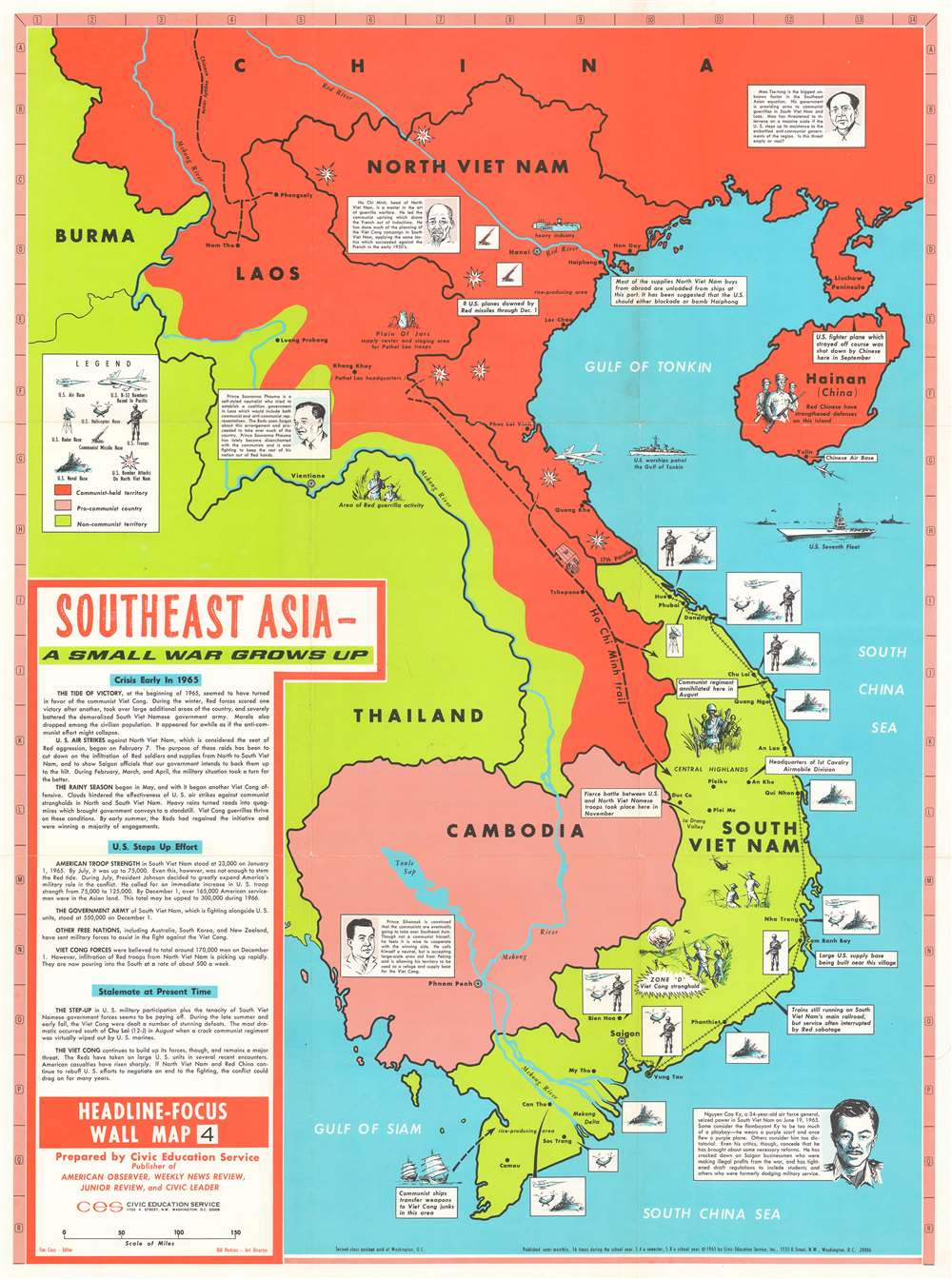
Southeast Asia - A Small War Grows Up. Headline-Focus Wall Map 4.
1965 (dated) 37 x 26.5 in (93.98 x 67.31 cm) 1 : 1940000
1965 (dated) 37 x 26.5 in (93.98 x 67.31 cm) 1 : 1940000
Description
This is a 1965 Civil Education Service pictorial map of Southeast Asia. The map depicts the region from Burma and Thailand to the South China Sea and from China to the Gulf of Siam and the Ca Mau Peninsula. A product of the Cold War and the Vietnam War, the ideological fight between communism and capitalism is immediately apparent, with communist countries shaded red and capitalist countries shaded an almost neon green – ‘the color of money’, ironically. China and North Vietnam are colored red, while Laos is half red and half green, a vivid illustration of the fight between the Pathet Lao forces and the anti-communist government backed forces in that country. Thailand, Burma, and South Vietnam are all green, while Cambodia is a dull red, indicating its pro-communist stance but its officially neutral stance. Icons along the South Vietnamese coast indicate the locations of American naval, helicopter, and air bases situated throughout the country, as well as troop concentrations. Text boxes provide some context, highlighting for example the headquarters of the 1st Cavalry Airmobile Division and locations of important battles between communist and American forces. Other vignettes highlight the now famous Ho Chi Minh Trail, the North Vietnamese supply route from North Vietnam, through Laos, into South Vietnam, areas of guerrilla activity, and the U.S. Seventh Fleet stationed over the Vietnamese Coast. Short biographies of important leaders, including Ho Chi Minh, Nguyen Cao Ky, a South Vietnamese air force general who seized power in June 1965, Prince Sihanouk of Cambodia, and Prince Souvanna Phouma of Laos are included as well, and are accompanied by portraits. A text box in the lower left corner provides context and information concerning America’s escalating role in the region and an assessment of the current state of affairs there.
Publication History and Census
This map was created and published by the Civil Education Service in 1965. The OCLC catalogues this map was being part of the collection at nine institutions: the University of Maine at Orono, Cornell University, the Buffalo and Erie County Public Library, the University of Chicago, the Wisconsin Veterans Museum Research Center, Auburn University, Utah State University, the University of Arizona, and the University of California, Riverside. It is rare on the private market.Cartographer
The Civic Education Service (fl. c. 1939 - 1945, 1963 - 1972) was a publishing firm based in Washington, D.C. that produced maps and other visual material for academic purposes. Our research has led us to believe that an organization known as the Civic Education Service existed from c. 1939 - c. 1945 (during World War II) and from c. 1963 - c. 1972. We have been unable to determine if this is the same organization that was closed for almost twenty years, or if the organization that published maps and other educational materials in the 1960s and 1970s was unrelated to the Civic Education Service that published books, maps, and other materials during World War II. More by this mapmaker...
Condition
Very good. Even overall toning. Light wear along original fold lines. Light soiling. Blank on verso.
References
OCLC 182561384.