This item has been sold, but you can get on the Waitlist to be notified if another example becomes available, or purchase a digital scan.
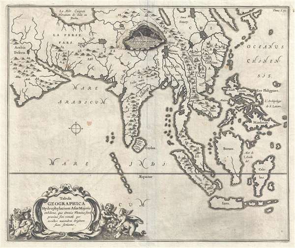
1665 Kircher Map of Southeast Asia, China, India, and the East Indies
SoutheastAsia-kircher-1665$600.00

Title
Tabula Geographica Hydrophylacium Asiae Majoris exhibens, quo Omnia Flumina sive proximè sive remotè per occultos meandros Originem suam sortiuntur.
1665 (undated) 14 x 16.5 in (35.56 x 41.91 cm) 1 : 23000000
1665 (undated) 14 x 16.5 in (35.56 x 41.91 cm) 1 : 23000000
Description
A fine example of Athanasius Kircher's 1665 map of Asia. Centered on India, this map covers from the Arabian Peninsula to the Philippines and from the Caspian Sea and Japan to java. It is one of several maps prepared by Kircher to illustrate his unique hydro-geographic theory. Kircher hypothesized that tides and currents are caused by water moving to and from a massive subterranean ocean. Kircher further postulated that water entered and exited the subterranean ocean via a number of great abysses situated around the globe. In addition, he believed that massive underground lakes lay beneath most of the world's great mountain ranges – one such lake is apparent here and the obvious centerpiece of the map. Although Kircher's theories were revolutionary at the time, they seem simplistic, even ridiculous to us today. Nonetheless, Kircher's maps were among the first thematic maps to attempt to scientifically illustrate and explain global geological and oceanographic phenomena.
This map was issued to accompany the 1665 edition of Kircher's Mundus Subterranous.
This map was issued to accompany the 1665 edition of Kircher's Mundus Subterranous.
Cartographer
Athanasius Kircher (c. 1601 - 1680) was a 17th century German Jesuit scholar and one of the most respected and remarkable men of his time. A master of languages, mathematics, science, geography, physics and oriental studies, many consider Kircher to be 'the last true Renaissance man.' Kircher attained almost global fame in his lifetime for his numerous scholarly publications. Indeed, Kircher was the first documented scholar able to fully support himself on his own work, which, in his case, included some forty volumes on diverse fields. As a Catholic in Germany, Kircher was frequently at odds with the rising powers of Protestantism. Consequently, in 1628 he joined the priesthood and after extensive world travels eventually settled in Rome. There he was employed as a Professor of Mathematics and Oriental Languages at the Collegio Romano. Inspired by the eruption of Vesuvius in 1637 and the two weeks of earthquakes that shook Calabria in 1638, Kircher turned his considerable intellect to the natural world. Kircher's research into Geography and Oceanography culminated in the postulation that tides and currents were caused by water moving to and from a great subterranean ocean. Kircher published his geographic work in the important 1664 Mundus Subterraneus, which in addition to several world and oceanic charts, included a fascinating map of Atlantis. Kircher is nonetheless, not unimpeachable. One anecdote tells how a rival scholar presented Kircher with a manufactured gibberish manuscript he claimed to be an recently discovered ancient Egyptian text in need of translation. Kircher produced the translation instantly. In addition to his significance as a scholar, Kircher is best known for his invention of the Magic Lantern, precursor to modern cinema. He also founded the Museum Kircherianum in Rome. More by this mapmaker...
Source
Kircher, A., Mundus Subterranous, (Amsterdam) 1665.
Condition
Very good. Original pressmark visible. Minor foxmark in the Arabian Sea.
References
OCLC 669113203. Durand, F., Maps of Malaya and Borneo: Discovery, Statehood and Progress, page 104, plate 30.