This item has been sold, but you can get on the Waitlist to be notified if another example becomes available, or purchase a digital scan.
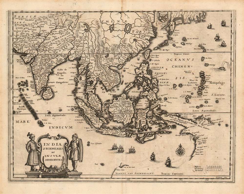
1646 Merian Map of the East Indies
SoutheastAsia-merian-1646$500.00

Title
India Orientalis et Insulae Adiecentes.
1646 (undated) 10.5 x 14 in (26.67 x 35.56 cm) 1 : 19000000
1646 (undated) 10.5 x 14 in (26.67 x 35.56 cm) 1 : 19000000
Description
This is a scarce 1638 Matthais Merian map of India, Southeast Asia, China, and Japan, including some of the earliest mapped portions of Australia. The map is beautifully engraved, decorated with nine sailing ships, a sea monster, and an elegant compass rose; the title cartouche is flanked by soldiers in Mogul garb. The mapping of India appears to be largely consistent with that of Linschoten. The Philippines are shown in sharp detail, albeit exaggerated in size. New Guinea is shown according to Le Maire's charting.
Early Glimpses of Australia
This map is among the earliest to depict any parts of Australia based on documented discovery - in particular, G. F. de Wits Land marks the site where the Dutch vessel Vianen in 1628 under her captain, Gerrit Frederikszoon de Witt, would run aground on the northwest coast of Australia. De Witt went on to chart the northwest coast about as far as the present-day location of Port Hedland. The map also shows the lands charted in 1605 - 1606 on the western coast of Queensland by Willem Janszoon (no relation to Jansson or Willem Janszoon Blaeu).Tracing the Sources
The map is a scrupulously precise reduced version of Blaeu's 1634 India quae Orientalis dicitur et Insulae Adiacentes. Hondius also produced a nearly identical version of the map in 1638. The differences between them are largely cosmetic - the Jansson lacks longitude lines, and the two maps' title and dedicatory cartouches are quite different. The cartographic detail of the two maps differs in a handful of areas: on the Japanese island of Shikoku, named Tokoesy on both maps, Hondius' copy lacks the symbol for the city 'Tonsa;' in the small portion of western Australia that appears, Blaeu includes the place name 'Willems Revier' where it is lacking on Hondius' copy. Merian's depiction of these areas corresponds to Blaeu's; this, and his imitation of Blaeu's title cartouche art suggests that Merian drew on the Blaeu as his source, and not the later Hondius map.What were Blaeu's sources for this map?
The coast of China appears to correspond with Luis Jorge de Barbuda's place names found on Ortelius' 1584 map. (The interior lakes of China shown here are drawn from Blaeu's specific map of China: this area was obscured by the title cartouche on Blaeu's map of Southeast Asia.) The southern Korean coast and the whole southern coast of Japan appears to have been drawn from a 1621 manuscript chart by Hessel Gerritz, produced while he was the first exclusive cartographer of the Dutch East India Company. The Blaeu family's long connection with this accomplished chart maker bore fruit for many years. Interestingly, Gerritz's chart made no reference to the insularity of Korea - though Blaeu named 'Corea Insul' on his map to make it consistent with his other maps of the region, and Merian copied this. Another key contribution of Gerrtitz was from his 1627 Caert van't Landt van d'Eendracht. This appears at the bottom center of the map: a portion of the coast of Western Australia, along with the place name, 'Willems Revier.' Gerritz reported that this river had been visited by the crew of the Dutch ship Mauritius in July 1618. (The identity of this river is unknown; it may be the Ashburton River.) Further to the west, also drawn from the same source, are a small group of islands marked 'Trial.' These represent one of the earliest appearances on a map of the Tryal Rocks, so named because of the June 1622 shipwreck of the English ship, Trial.A Proliferation of 'Thieves'
Several locations on the map bear variations on the place name 'Ladrones.' In the southeast corner of the map are the Insulae Ladrones, which are now understood as the Mariana Islands; a further I. de Ladrones appears on the southern coast of Korea, corresponding roughly with Jeju Island. In both cases, the name is derived from the Spanish and Portuguese word for 'Thieves.' The appellation of 'Ladrones' in the Marianas dates back to report of Magellan's reception in Guam by the Chamorros, who boarded the ship and stole whatever could be taken. As for Korea, the archipelago inclusive of Jeju and Tsushima gained a reputation for piracy - at the least, the passive piracy of stripping wrecks. The name appears on maps of Korea going back to the 1595 Ortelius and the 1596 Linschoten, so it is unsurprising to see it surviving here.Apocryphal Lake Chiamay
The mythical Lake of Chiamay appears at the western extreme of the map, roughly in what is today Assam, India. Early cartographers postulated that such a lake must exist to source the four important Southeast Asian river systems: the Irrawaddy, the Dharla, the Chao Phraya, and the Brahmaputra. This lake began to appear in maps of Asia as early as the 16th century and persisted well into the mid-18th century. Its origins are unknown but may originate in a lost 16th-century geography prepared by the Portuguese scholar Jao de Barros. It was also heavily discussed in the journals of Sven Hedin, who believed it to be associated with Indian legend that a sacred lake, Mansarovar, linked several of the holy subcontinent river systems. There are even records that the King of Siam led an invasion force to take control of the lake in the 16th century. Nonetheless, the theory of Lake Chiamay was ultimately disproved, and it disappeared from maps entirely by the 1760s.Publication History and Census
This map was executed in 1638 for inclusion in Matthias Merian's Neuwe Archontologia cosmica, a German translation of Pierre d'Avity's 1616 Les Estats, empires, et principautez du monde. We identify about ten examples of later editions of Merian's Neuwe Archontologia cosmica in institutional collections, and sixteen examples of this separate map are also catalogued, in various editions.CartographerS
Matthäus Merian (September 22, 1593 - June 19, 1650), sometimes referred to as 'the Elder' to distinguish from his son, was an important Swiss engraver and cartographer active in the early to mid 17th century. Merian was born in Basel and studied engraving in the centers of Zurich, Strasbourg, Nancy and Paris. In time Merian was drawn to the publishing mecca of Frankfurt, where he met Johann Theodor de Bry, son of the famed publisher Theodor de Bry (1528 - 1598) . Merian and De Bry produced a number of important joint works and, in 1617, Merian married De Bry's daughter Maria Magdalena. In 1623 De Bry died and Merian inherited the family firm. Merian continued to publish under the De Bry's name until 1626. Around this time, Merian became a citizen of Frankfurt as such could legally work as an independent publisher. The De Bry name is therefore dropped from all of Merian's subsequent work. Of this corpus, which is substantial, Merian is best known for his finely engraved and highly detailed town plans and city views. Merian is considered one of the grand masters of the city view and a pioneer of the axonometric projection. Merian died in 1650 following several years of illness. He was succeeded in the publishing business by his two sons, Matthäus (1621 - 1687) and Caspar (1627 - 1686), who published his great works, the Topographia and Theatrum Europeaum, under the designation Merian Erben (Merian Heirs). Merian's daughter, Anna Maria Sibylla Merian, became an important naturalist and illustrator. Today the German Travel Magazine Merian is named after the famous engraver. More by this mapmaker...
Hessel Gerritsz (1581 – September 4, 1632) was a Dutch engraver, cartographer, and publisher active in Amsterdam during the late 16th and early 17th centuries, among the most preeminent Dutch geographers of the 17th century. He was born in Assum, a town in northern Holland in 1581. As a young man he relocated to Alkmaar to accept an apprenticeship with Willem Jansz Blaeu (1571-1638). He followed Blaeu to Amsterdam shortly afterwards. By 1610 he has his own press, but remained close to Blaeu, who published many of his maps. In October of 1617 he was appointed the first official cartographer of the Vereenigde Oost-Indische Compagnie (Dutch East Indian Company) or VOC. This strategic position offered him unprecedented access to the most advanced and far-reaching cartographic data of the Dutch Golden Age. Unlike many cartographers of his period, Gerritsz was more than a simple scholar and showed a true fascination with the world and eagerness to learn more of the world he was mapping in a practical manner. In 1628 he joined a voyage to the New World which resulted in the production of his seminal maps, published by Joannes de Laet in his 1630 Beschrijvinghe van West-Indien; these would be aggressively copied by both the Blaeu and Hondius houses, and long represented the standard followed in the mapping of the new world. Among his other prominent works are a world map of 1612, a 1613 map of Russia by the brilliant Russian prince Fyodor II Borisovich Godunov (1589 – 1605), a 1618 map of the pacific that includes the first mapping of Australia, and an influential 1630 map of Florida. Gerritsz died in 1632. His position with the VOC, along with many of his printing plates, were taken over by Willem Janszoon Blaeu. Learn More...
Willem Janszoon Blaeu (1571 - October 18, 1638), also known as Guillaume Blaeu and Guiljelmus Janssonius Caesius, was a Dutch cartographer, globemaker, and astronomer active in Amsterdam during the late 16th and early 17th centuries. Blaeu was born 'Willem Janszoon' in Alkmaar, North Holland to a prosperous herring packing and trading family of Dutch Reformist faith. As a young man, he was sent to Amsterdam to apprentice in the family business, but he found the herring trade dull and instead worked for his cousin 'Hooft' as a carpenter and clerk. In 1595, he traveled to the small Swedish island of Hven to study astronomy under the Danish Enlightenment polymath Tycho Brahe. For six months he studied astronomy, cartography, instrument making, globe making, and geodesy. He returned to Alkmaar in 1596 to marry and for the birth of his first son, Johannes (Joan) Blaeu (1596 – 1673). Shortly thereafter, in 1598 or 1599, he relocated his family to Amsterdam where he founded the a firm as globe and instrument makers. Many of his earliest imprints, from roughly form 1599 - 1633, bear the imprint 'Guiljelmus Janssonius Caesius' or simply 'G: Jansonius'. In 1613, Johannes Janssonius, also a mapmaker, married Elizabeth Hondius, the daughter of Willem's primary competitor Jodocus Hondius the Elder, and moved to the same neighborhood. This led to considerable confusion and may have spurred Willam Janszoon to adopt the 'Blaeu' patronym. All maps after 1633 bear the Guiljelmus Blaeu imprint. Around this time, he also began issuing separate issue nautical charts and wall maps – which as we see from Vermeer's paintings were popular with Dutch merchants as decorative items – and invented the Dutch Printing Press. As a non-Calvinist Blaeu was a persona non grata to the ruling elite and so he partnered with Hessel Gerritsz to develop his business. In 1619, Blaeu arranged for Gerritsz to be appointed official cartographer to the VOC, an extremely lucrative position that that, in the slightly more liberal environment of the 1630s, he managed to see passed to his eldest son, Johannes. In 1633, he was also appointed official cartographer of the Dutch Republic. Blaeu's most significant work is his 1635 publication of the Theatrum orbis terrarum, sive, Atlas Novus, one of the greatest atlases of all time. He died three years later, in 1638, passing the Blaeu firm on to his two sons, Cornelius (1616 - 1648) and Johannes Blaeu (September 23, 1596 - December 21, 1673). Under his sons, the firm continued to prosper until the 1672 Great Fire of Amsterdam destroyed their offices and most of their printing plates. Willem's most enduring legacy was most likely the VOC contract, which ultimately passed to Johannes' son, Johannes II, who held the position until 1617. As a hobbyist astronomer, Blaeu discovered the star now known as P. Cygni. Learn More...
Source
Merian, M. Neuwe Archontologia cosmica (Franckfurt am Mayn), 1646.
Condition
Very good condition. Extremities of margins toned, else excellent with a bold, sharp strike.
References
OCLC 163863538. Keuning, Johannes. 'Hessel Gerritsz.' Imago Mundi, vol. 6, 1949, pp. 49–66.