
This item below is out of stock, but another example (left) is available. To view the available item, click "Details."
Details
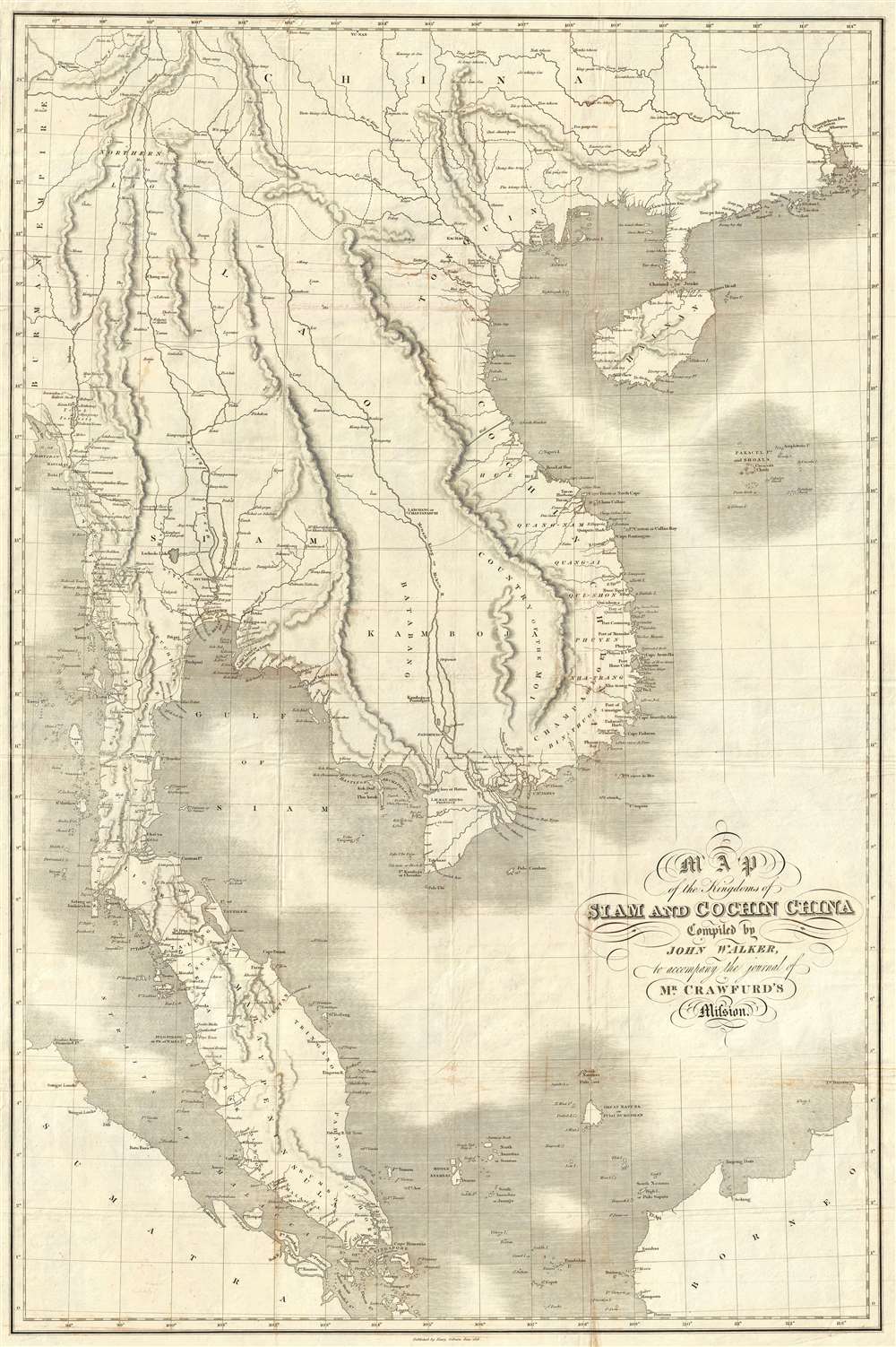
1828 Crawfurd / Walker Map of Southeast Asia - first accurate map of Thailand!
$2,800.00
1828 Crawfurd / Walker Map of Southeast Asia - first accurate map of Thailand!
SoutheastAsiaSiam-crawfurdwalker-1828$1,750.00

Title
Map of the Kingdoms of Siam and Cochin China.
1828 (dated) 37 x 25 in (93.98 x 63.5 cm) 1 : 3000000
1828 (dated) 37 x 25 in (93.98 x 63.5 cm) 1 : 3000000
Description
This rare large-format 1828 map of Southeast Asia, compiled by John Walker to illustrate John Crawfurd’s mission to Siam (Thailand) is the first accurate survey of the coasts of Siam. Coverage extends from China to Singapore and from the Gulf of Martaban (Burma) to Vietnam and Hainan. Siam at the time was inaccessible to European merchants and even diplomats with its coasts and interior were largely unknown. This map is an amalgam of European sources, but with regard to Siam, derived primarily from secretly acquired early 19th century Siamese surveys previously unknown to Europeans and, for all intent and purposes, still lost.... a great deal of useful information ... as we approached Siam they became much more shy and reserved, and now communicated nothing without a strict injunction to secrecy. They constantly resisted our solicitations to assist in translating the Governor-general's letter into Siamese, observing that the communication of his Majesty's titles would be considered as the divulgement of a state secret, which might cost them their lives. The commander ... passed his hand over his neck on such occasions, to represent the operation of a sword, that no doubt might be entertained of the nature of his apprehensions.Who this figure may have been has been lost to time, but Crawfurd does record meeting two Muslim Siamese mariners in Penang that he knew previously in Calcutta, one a pilot, and the other a ship captain. It was most likely the pilot who provided the maps, as Crawfurd speaks well of him and poorly of the captain, but either might have provided the information for this map.
The map appeared in the first edition of John Crawfurd's Journal of an Embassy from the Governor-General of India to the courts of Siam and Cochin-China: exhibiting a view of the actual state of those kingdoms. The Journal and accompanying map was published in London by H. Colburn in 1828.
The map is rare to the market with no other examples currently available. The OCLC identifies 5 examples of the map in institutional collections, and numerous examples of the book in various editions where it unclear if the map is present.
Historical Context
Following the resurgence of the Kingdom of Siam after the Burmese–Siamese War of 1765 -1767, Siam emerged as a major political power and the central state in Southeast Asia. The regional destabilization of the Siamese victory led to a power vacuum in Burma that precipitated a series of further conflicts, both between Siam and Burma, and between Burma and Great Britain, lasting well into the early 19th century. The British took advantage of the weak Burmese military to seize additional territory in Assam, Manipur, and Arakan, during the First Anglo-Burmese War (1824–1826). At the same time Siam continued to grind away at both Burmese territory to the west, and annexed parts of Laos and Cambodia to the east, stopped only by a Vietnamese and French forces in Indochina. To the south, Britain exerted strong influence over the Malay States, leaving only Siam as a fully independent and powerful Southeast Asian state resistant to European influence.The Crawfurd Mission
The Scottish linguist, diplomat, doctor, and colonial administrator John Crawfurd (1783 - 1868) was sent to the Kingdom of Siam by Governor-General of India, Lord Francis Edward Rawdon-Hastings. Hastings was interested in evaluating the growing power of Siam, establishing a reliable reconnaissance of Siamese lands, establishing trade relations, and understanding Siamese policy with regard to both the Malay States to the south (particularly Penang, to which the British had laid claim) and to French attempts to establish a colonial presence in Vietnam. While the mission failed to establish trade relations, evaluate Siamese political positions regarding Penang, or explore the interior, he did collect cartographic materials detailing the coast, much of which John Walker compiled into this map.The 'Mohammedan Mariner'
In the appendix to Crawfurd's Journal of an Embassy from the Governor-General of India to the Courts of Siam and Cochin-China, he lists the sources of this remarkable map. Many are new surveys conducted en route, earlier British surveys of the Malay States and Bengal, and French sources for Indochina, but the bulk of the map as it relates to Siam is based upon cartography passed clandestinely to Crawfurd by a 'Mohammedan Mariner' and native of Siam. To quote Crawfurd,From the Cape of Patani to the point of Kwiis taken from a Mohammedan mariner, a native of Siam, possessed of considerable intelligence-who was acquainted with the use of maps and the quarterstaff, and could even take an altitude of the sun with our quadrants...he goes on to describe how this same mariner, in fear of his life, divulged less and less information the closer the came to Siam,
A Wall in Vietnam?
The map exhibits a wall in Vietnam just north of the city of Hué. The wall bisects Vietnam or Cochin-China horizontally from the Truong Son Mountains to the to the Pacific. This is probably misrepresentation of the Long Wall of Quảng Ngãi, which was being manned at the time. The Long Wall in fact ran north-south, not east-west, and followed parallel to the Truong Son, extending through ten districts—Trà Bồng, Sơn Tịnh, Sơn Hà, Tư Nghĩa, Minh Long, Nghĩa Hành, Ba Tơ, Đức Phổ, Hoài Ân, and An Lão. It covers some 79 miles (127.4km) from Quảng Ngãi Province in the north to Binh Dinh Province in the south. This inaccurate representation of the wall is hardly surprising given that the map exhibits almost no inland detail in Vietnam. This is because, when Crawfurd's embassy arrived in Saigon, they were turned away by Minh Mạng, the second Nguyễn Emperor.Census and Publication History
The map was edited and complied by John Walker, reportedly from two or three large format manuscript charts traced from 'native charts' presumably provided by said 'Mohammedan.' The work exhibits Walker's masterful ability to combine work from various sources into a cohesive whole as well as his expert engraving skill.The map appeared in the first edition of John Crawfurd's Journal of an Embassy from the Governor-General of India to the courts of Siam and Cochin-China: exhibiting a view of the actual state of those kingdoms. The Journal and accompanying map was published in London by H. Colburn in 1828.
The map is rare to the market with no other examples currently available. The OCLC identifies 5 examples of the map in institutional collections, and numerous examples of the book in various editions where it unclear if the map is present.
Cartographer
John Walker (1787 - April 19, 1873) was a British map seller, engraver, lithographer, hydrographer, geographer, draughtsman, and publisher active in London during the 19th century. Walker published both nautical charts and geographical maps. His nautical work is particularly distinguished as he was an official hydrographer for the British East India Company, a position, incidentally, also held by his father of the same name. Walker's maps, mostly published after 1827, were primarily produced with his brothers Charles Walker and Alexander Walker under the imprint J. and C. Walker. Among their joint projects are more than 200 maps for the influential Society for the Diffusion of Useful Knowledge Atlas (SDUK). In addition they published numerous charts for James Horsburgh and the British Admiralty Hydrographic Office, including Belcher's important map of Hong Kong and Carless' exploratory map of Karachi. The J. and C. Walker firm continued to publish after both Walkers died in the 1870s. More by this mapmaker...
Source
Crawfurd, J., Journal of an Embassy from the Governor-General of India to the courts of Siam and Cochin-China: exhibiting a view of the actual state of those kingdoms, (London: H. Colburn), 1828.
Condition
Very good. Some wear and verso reinforcement on original fold lines. Slight foxing and transference.
References
Sternstein, L., 'The London Company's Envoys Plot Siam', The Journal of the Siam Society vol 81, pt. 2 (1993), pages 20-21. Suarez, Thomas, Early Mapping of Southeast Asia, (Hong Kong: Periplus) pages 31-32.