This item has been sold, but you can get on the Waitlist to be notified if another example becomes available, or purchase a digital scan.
1926 Matthews Northrup Map of the Southern Railway System - Southeastern US
SouthernRailwaySystem-matthewsnorthrup-1926$225.00

Title
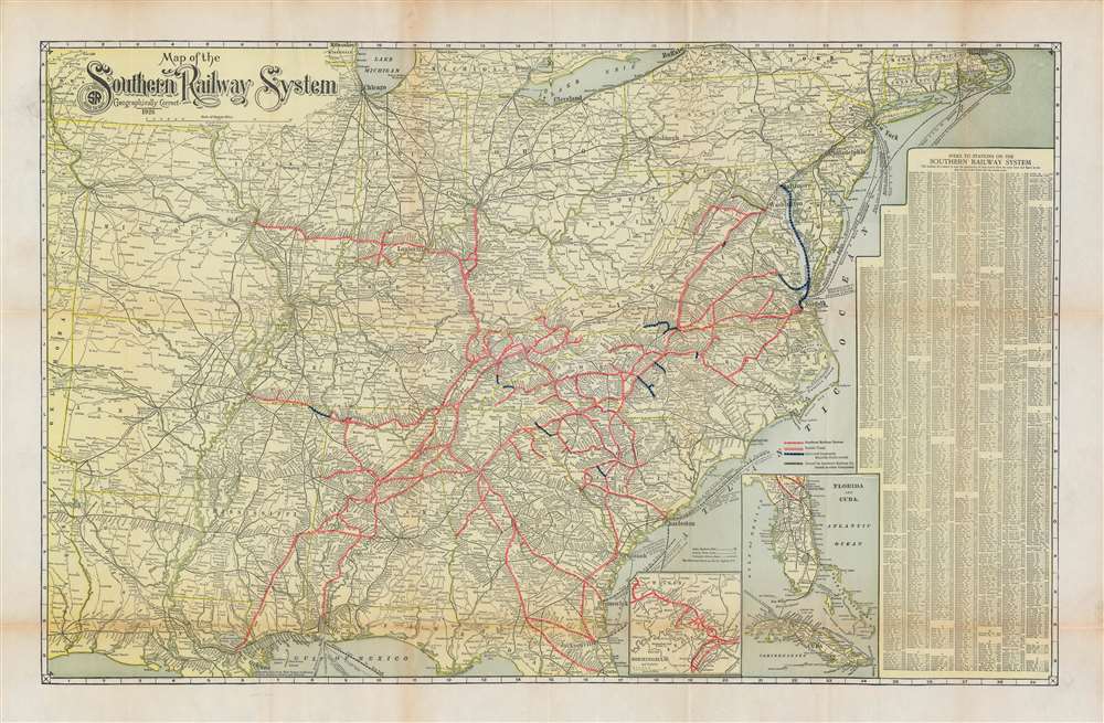
Map of the Southern Railway System Geographically Correct.
1926 (dated) 20.5 x 31.5 in (52.07 x 80.01 cm) 1 : 3168000
1926 (dated) 20.5 x 31.5 in (52.07 x 80.01 cm) 1 : 3168000
Description
A scarce 1926 Matthews Northrup map of the southeastern and southcentral United States detailing the routes of the Southern Railway System. The map covers from the Sabine River and Oklahoma borderlands eastward to the Atlantic Seaboard and from the Great Lakes to the Gulf of Mexico. Coverage is extended to include Florida via an inset. Rail lines either owned outright, in part, or leased by the Southern Railway are highlighted and color-coded. The map also notes steamship routes that provide vital maritime connections to various domestic and foreign ports.
The Southern Railroad
The Southern Railroad was a class 1 railroad based in the southeastern United States between 1894 and 1982. The railroad can trace its origins to the South Carolina Canal and Rail Road Company, one of the first railroad operators in the United States, chartered in 1827. The railroad network in the southern United States was devastated by the American Civil War (1862 - 1865), but quickly rebuilt after the war - relying heavily on the 'chain gang' system of convict labor to repair and expand the network. The Southern Railway formally came into existence in 1894, with the merger of the 'Memphis and Charleston Railroad', the 'Richmond and Danville System', and the 'East Tennessee, Virginia and Georgia Railroad'. The network continued to expand, building, buying, and leasing other lines through the mid-20 century. Starting in 1939, the Southern Railway went under dieselization, and by 1953, was the first major railroad in the United States to be fully converted from steam to diesel. In 1982, the Southern was acquired by the 'Norfolk and Western' to form 'Norfolk Southern'.Publication History and Census
Variants of this map appear as early as 1922. Each edition is a distinct separate map, often by different publishers, suggesting that the Southern had an uneasy relationship with its printers. The present issue was prepared in 1926 by the Matthew Northrup firm of Buffalo, New York. Scarce to the market in this edition.Cartographer
Matthews-Northrup Works (fl. c. 1895 - 1930) were a Buffalo, New York based, in their own words, "writing, designing, engraving, printing, [and] binding" firm. The firm was founded by James Newson Matthews (November 21, 1828 - December 20, 1888) as the J. N. Matthews Company. William Phelps Northrup (April 2, 1850 - February 2, 1929) later joined the company as an apprentice and then partner, at which point the firm was reincorporated as the Matthews-Northrup Works. The Matthews-Northrup Works rose to prominence as publishers and printers of railroad maps, with dozens to their credit. When James died, his shares were inhered by George Edward Matthews (1855 - 1910), who ran the business until his death in 1910. Also in 1910, they famously redesigned the cover of National Geographic Magazine. Despite some six previous cover changes in just 21 years, the Matthews-Northrup layout proved so popular that it was used for nearly 50 years. The firm can also take credit for the Winchell typeface, designed in 1903 under E. E. Winchell's tenure as art director. Curiously, the partners of Matthews-Northrup maintained an unusual affectation in which only the officers of the company could wear beards or mustaches. In this same spirit, the firm also had its own private social club, the Fellowcraft Club, where the all-male employees could relax, play pool, drink and dine. Matthews-Northrup maintained offices on Washington Street, Buffalo, where they were based, as well as Madison Square, New York City, Garden Tower, Boston, and the Citizens Building in Cleveland. More by this mapmaker...
Condition
Very good. Accompanied by original binder.