This item has been sold, but you can get on the Waitlist to be notified if another example becomes available.
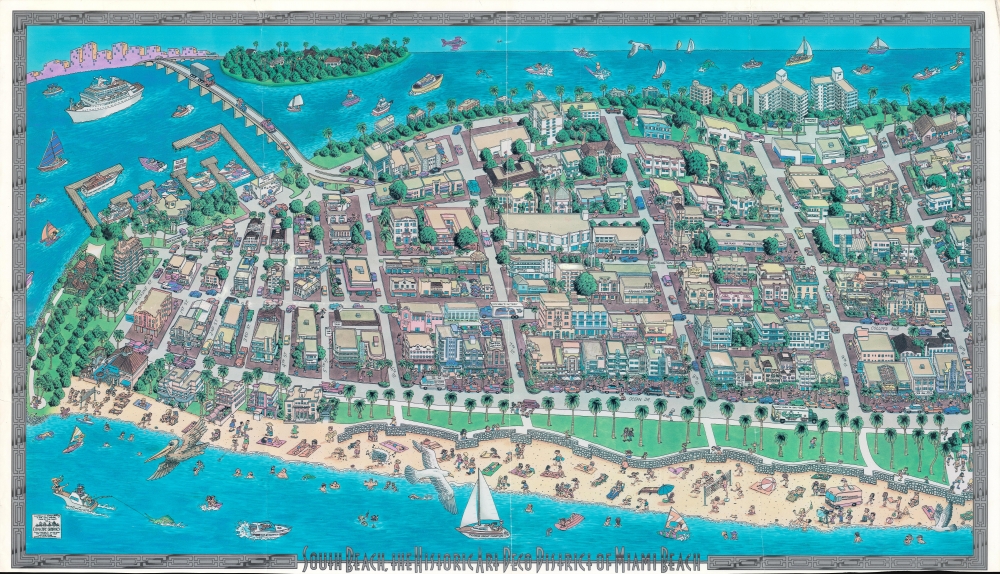
1993 Cityscape Graphics Pictorial View of South Beach (Southern Part), Miami Beach
SouthernSouthBeach-cityscapegraphics-1993$400.00


Title
South Beach, the Historic Art Deco District of Miami Beach.
1993 (dated) 21 x 37 in (53.34 x 93.98 cm)
1993 (dated) 21 x 37 in (53.34 x 93.98 cm)
Description
A large and impressive pictorial view of the southern portion of South Beach, Miami Beach, Florida, produced in 1993 by Cityscape Graphics. In addition to highlighting local businesses and attractions, it also focuses on the area's distinctive art deco style architecture.
A Closer Look
Oriented towards the west, this view takes in the southern portion of the South Beach neighborhood of Miami Beach, Florida. Beachgoers engaged in a variety of leisure activities fill the foreground, along with shops, restaurants, hotels, and greenspace along Ocean Drive. In the background, additional restaurants, shops, and landmarks appear, further demonstrating the area's unique architectural heritage. At left, adjacent to the Miami Beach Marine, the MacArthur Causeway provides one of two road links between South Beach and Miami.Miami Beach
In 1900, Miami Beach was part of the John S. Collins (1837 - 1928) avocado plantation. Collins understood the potential of the barrier islands as a resort hub, but the farmlands, tangled mangrove swamps, and general inaccessibility stood in the way of serious development. Nonetheless, with help from investors, Collins persisted and in 1913 constructed a 2.5-mile wooden bridge, the Collins Bridge - at the time the world's longest - connecting Miami to Miami Beach. Collins, and his fellow investors Carl G. Fisher (1874 - 1939) and the Lummus brothers, built elegant mansions on the island, setting off the Miami Beach building rush and the Florida Land Boom in general, which reached its apex in the mid-1920s, bequeathing the city the fabulous art deco architecture for which it is renowned. Prior to 1980, these historic buildings were regularly torn down to make way for new development, but starting in the late 1970s a group of residents and preservationists were able to have a large section of South Beach entered into the National Register of Historic Places.Publication History and Census
This view was produced by Cityscape Graphics in 1993, with illustrations by Gary Whitney and Rob Zell-Brewer, and color by Teri Cheney. Little information is available about the firm or the artists, aside from their involvement with a company known as International Caricature Productions (likely a predecessor to Cityscape Graphics) in the late 1980s. This view has a 'sister' view covering the northern part of South Beach (previously sold by us) with the same title. The only other known examples of the views are held by the University of Miami School of Architecture's Architectural Drawings and Maps Collection.Cartographer
Robert Zell-Breier (July 26, 1947 - April 7, 2010) was an American artist known for hand-drawn poster maps and montages. Zell-Breier attended the Newark School of Fine and Industrial Arts and the Maryland Art Institute. More by this mapmaker...
Condition
Good. Wear and creases along fold lines. Dogear crimp at top-right corner. Uneven trim along bottom edge.