This item has been sold, but you can get on the Waitlist to be notified if another example becomes available, or purchase a digital scan.
1809 Pinkerton Map of the Southern States
SouthernStates-pinkerton-1809$375.00

Title
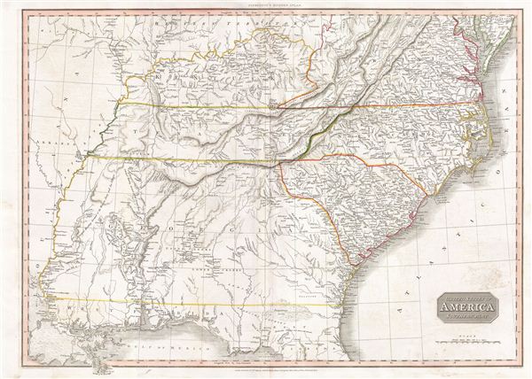
United States of America Southern Part.
1809 (dated) 20.5 x 28 in (52.07 x 71.12 cm) 1 : 2200000
1809 (dated) 20.5 x 28 in (52.07 x 71.12 cm) 1 : 2200000
Description
A scarce and important 1809 map of the southeastern part of the United States by John Pinkerton. The map covers from the Mississippi River eastward to the Atlantic, extending north as far as Delaware, and south to northern Florida and the Mississippi River Delta. The states of Virginia, Kentucky, Tennessee, North Carolina, South Carolina and Georgia are illustrated in full while Florida, Alabama, and Mississippi have yet to appear as either states or territories. Florida was not yet part of the United States but would join ten years after this map was printed in 1819. This map was created during the transitional period of expansion shortly following the American Revolutionary War and is among most thorough treatments of this region prior to the U.S. Government Surveys.
This map is particularly interesting for its detailed treatment of American Indian activity between the Mississippi and the Appalachian Mountains. American Indian nations are noted throughout, including the Creek, Seminole, Apache, Choctaw and Chickasaw, among others. Hunting grounds, villages and fortifications are also identified, sometimes accompanied by the date on which they were destroyed. Pinkerton additionally identifies the Wabash Company, the Jersey Company and the Illinois Company - joint stock ventures formed during the colonial period to acquire, sell, and colonize American Indian lands.
Drawn by L. Herbert and engraved by Samuel Neele under the direction of John Pinkerton. Published in London by 'Cadell and Davies' and 'Longman Hurst Ress & Ormes' for John Pinkerton's
Cartographer
John Pinkerton (February 17, 1758 - March 10, 1826) was an Scottish writer, historian, and cartographer. Pinkerton was born in Edinburgh, Scotland. He was a studious youth with a passion for the classics. As a young man, he studied at Edinburgh University before apprenticing as a lawyer. Around this time, he began writing, with his first book, Elegy on Craigmillar Castle published in 1776. Pinkerton moved to London in 1781 to pursue his writing career in earnest. He successfully published several works of literature, poetry, and history. Pinkerton proved passionate in his literary and historical writings, but his correspondence with other cartographers has been labeled as aggressive, even insane. In addition to his work as a writer and historian, Pinkerton was one of the leading masters of the Edinburgh school of cartography which flourished from roughly 1800 to 1830. Pinkerton and his contemporaries (Thomson and Cary) redefined European cartography by abandoning typical 18th century decorative elements such as elaborate title cartouches and fantastical beasts in favor of detail and accuracy. Pinkerton's principle work is Pinkerton's Modern Atlas published from 1808 through 1815 with a special American reissue by Dobson and Co. in 1818. Pinkerton relocated to Paris in 1818, where he managed his publishing business until his death in 1826. More by this mapmaker...
Source
Pinkerton, John, A modern atlas, from the latest and best authorities, exhibiting the various divisions of the world, with its chief empires, kingdoms and states, in sixty maps, carefully reduced from the largest and most authentic sources, (London: Cadell & Davies, Longman Hurst Rees, & Orme) 1811.
Condition
Very good. Original centerfold exhibits some wear and verso reinforcement. Ample margins. Blank on verso.
References
Rumsey 0732.044. Phillips (atlases) 772.