This item has been sold, but you can get on the Waitlist to be notified if another example becomes available, or purchase a digital scan.
1867 Colton Map of the Southern States or 'Lost Cause'
SouthernStatesCivilWar-colton-1867$375.00

Title
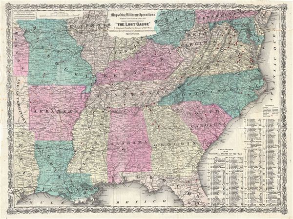
Map of the Military Operations During the War of 1861-1865 designed expressly to accompany 'The Lost Casue' A Standard Southern History of the War.
1867 (dated) 18 x 24 in (45.72 x 60.96 cm)
1867 (dated) 18 x 24 in (45.72 x 60.96 cm)
Description
An interesting and exceptionally influential 1867 post Civil War movement map of the Southern States drawn for edward A. Pollard's book The Lost Cause. The map covers from Ohio and Pennsylvania to central Florida and the Gulf of Mexico and from Texas and Arkansas eastward to the Atlantic. The sites of various Civil War battles are marked in red. In addition that map identifies major cities and towns, roads, canals, and railways. Topography is rendered by hachure. The map is surrounded by a decorative vine motif border. A textual chronology of the Civil War appears on the lower right quadrant. The upper right hand quadrant includes an advertisement for 'Colton's Geographical establishment' at 172 William Street, New York.
This map was specifically commissioned by Pollard and his publisher e. B. Treat, to illustrate The Lost Cause. Pollard's book marked the rise of a post-war southern sympathist movement of the same name. The Lost Cause movement was an apologist ideology that became popular among southern whites facing Reconstruction and the Confederate defeat. The basic tenants advocated that (1) Confederate generals were icons of southern chivalry, (2) that Union generals were cowardly and morally bankrupt, (3) that battlefield losses were inevitable due superior Union numbers, (4) that battlefield losses were also the result of treachery, (5) that states' rights not slavery were behind the succession, (6) that the succession was a constitutional reaction to northern attacks on the southern 'way of life,' and (7) that slavery was a benign institution. What most modern scholars decry the Lost Cause movement as a 'use of white supremacy as both a means and end,' it was in fact an important stage in the development of the 'New South' including a new business model and cultural ethic.
This map was specifically commissioned by Pollard and his publisher e. B. Treat, to illustrate The Lost Cause. Pollard's book marked the rise of a post-war southern sympathist movement of the same name. The Lost Cause movement was an apologist ideology that became popular among southern whites facing Reconstruction and the Confederate defeat. The basic tenants advocated that (1) Confederate generals were icons of southern chivalry, (2) that Union generals were cowardly and morally bankrupt, (3) that battlefield losses were inevitable due superior Union numbers, (4) that battlefield losses were also the result of treachery, (5) that states' rights not slavery were behind the succession, (6) that the succession was a constitutional reaction to northern attacks on the southern 'way of life,' and (7) that slavery was a benign institution. What most modern scholars decry the Lost Cause movement as a 'use of white supremacy as both a means and end,' it was in fact an important stage in the development of the 'New South' including a new business model and cultural ethic.
Cartographer
Joseph Hutchins Colton (July 5, 1800 - July 29, 1893), often publishing as J. H. Colton, was an important American map and atlas publisher active from 1833 to 1897. Colton's firm arose from humble beginnings when he moved to New York in 1831 and befriended the established engraver, Samuel Stiles. He worked under Stiles as the 'Co.' in Stiles and Co. from 1833 to 1836. Colton quickly recognized an emerging market in railroad maps and immigrant guides. Not a cartographer or engraver himself, Colton's initial business practice mostly involved purchasing the copyrights of other cartographers, most notably David H. Burr, and reissuing them with updated engraving and border work. His first maps, produced in 1833, were based on earlier Burr maps and depicted New York State and New York City. Between 1833 and 1855, Colton proceeded to publish a large corpus of guidebooks and railroad maps, which proved popular. In the early 1850s, Colton brought his two sons, George Woolworth Colton (1827 - 1901) and Charles B. Colton (1832 - 1916), into the map business. G. W. Colton, trained as a cartographer and engraver, was particularly inspired by the idea of creating a large and detailed world atlas to compete with established European firms for the U.S. market. In 1855, G.W. Colton issued volume one of the impressive two-volume Colton's Atlas of the World. Volume two followed a year later. Possibly because of the expense of purchasing a two-volume atlas set, the sales of the Atlas of the World did not meet Colton's expectations, and so, in 1856, the firm also issued the atlas as a single volume. The maps contained in this superb work were all original engravings, and most bear an 1855 copyright. All of the maps were surrounded by an attractive spiral motif border that would become a hallmark of Colton's atlas maps well into the 1880s. In 1857, the slightly smaller Colton's General Atlas replaced the Atlas of the World. Most early editions of the General Atlas published from 1857 to 1859 do not have the trademark Colton spiral border, which was removed to allow the maps to fit into a smaller format volume. Their customers must have missed the border because it was reinstated in 1860 and remained in all subsequent publications of the atlas. There were also darker times ahead; in 1858, Colton was commissioned at a sum of 25,000 USD by the government of Bolivia to produce and deliver 10,000 copies of a large format map of that country. Although Colton completed the contract in good faith, delivering the maps at his own expense, he was never paid by Bolivia, which was at the time in the midst of a series of national revolutions. Colton would spend the remainder of his days fighting with the Bolivian and Peruvian governments over this payment, and in the end, after a congressional intervention, he received as much as 100,000 USD in compensation. Nonetheless, at the time, it was a disastrous blow. J. H. Colton and Company is listed as one of New York's failed companies in the postal record of 1859. This led Colton into the arms of Alvin Jewett Johnson and Ross C. Browning. The 1859 edition of Colton's General Atlas lists Johnson and Browning as the 'Successor's to J. H. Colton' suggesting an outright buyout, but given that both companies continued to publish separately, the reality is likely more complex. Whatever the case may have been, this arrangement gave Johnson and Browning access to many of Colton's map plates and gave birth to Johnson's New Illustrated (Steel Plate) Family Atlas. The Johnson's Atlas was published parallel to Colton's atlases well into the 1880s. The Colton firm itself subsequently published several other atlases including an Atlas of America, the Illustrated Cabinet Atlas, the Octavo Atlas of the Union, and Colton's Quarto Atlas of the World. They also published a large corpus of wall maps, pocket maps, and guides. The last known publications of the Colton firm date to 1897 and include a map and a view, both issued in association with the Merchant's Association of New York. Alice M. Colton married August R. Ohman (May 3, 1859 - April 22, 1934) on January 5, 1897. In 1898, Ohman joined the Colton firm, which continued to publish as Colton, Ohman & Co. until 1901. More by this mapmaker...
Source
Pollard, E., The Lost Cause; A New Southern History of the War of the Confederates, (New York: E. B. Treat) 1868.
Condition
Vewry good. Original fold lines.