This item has been sold, but you can get on the Waitlist to be notified if another example becomes available, or purchase a digital scan.
1872 Corps of Engineers Map of the American Civil War Battle of South Mountain
SouthMountain-engineers-1872$175.00

Title
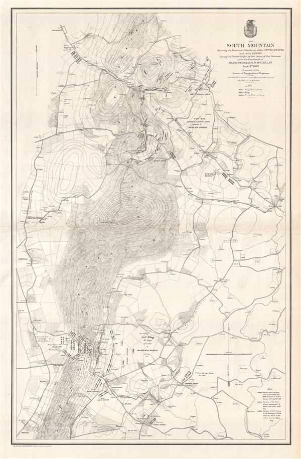
South Mountain Showing the Positions of the Forces of the United States and of the Enemy during the Battle fought by the Army of the Potomac under the Command of Major General G.B. McClellan Sept. 14th 1862.
1872 (dated) 32.25 x 21 in (81.915 x 53.34 cm) 1 : 18500
1872 (dated) 32.25 x 21 in (81.915 x 53.34 cm) 1 : 18500
Description
This is a separate issue 1872 U.S. Army Corps of Topographical Engineers map of the American Civil War Battle of South Mountain. South Mountain is the name given to the continuation of the Blue Ridge Mountains after they enter Maryland. A seventy-mile-long mountain range, South Mountain separates the Hagerstown Valley and the Cumberland Valley from the eastern part of Maryland. The map depicts the region from Rohrersville to east of Broadrun Village and from Boonsborough to Brownsville. Individuals homesteads are illustrated and labeled throughout, along with numerous roads (including the National Road to Frederick), and the Blue Ridge Mountains complete with contour lines. The positions of both Union and Confederate troops are illustrated at Crampton's, Turner's, and Fox's Gaps, with Union positions noted both before and after the battle. A key in the lower right corner explains the different notations used to differentiate between the different units.
The Battle of Stone Mountain
The Battle of Stone Mountain, also known as the Battle of Boonsboro Gap, was fought on September 14, 1862. A series of three concurrent battles for possession of three South Mountain passes, the Battle of South Mountain took place at Crampton's, Turner's, and Fox's Gaps. The battle began when General George McClellan, commander of the Union Army of the Potomac, received intelligence that Confederate General Robert E. Lee had split his force in two. After Lee invaded Maryland, he made the decision that one part of his army would attack Harper's Ferry in an effort to secure the rear of Lee's army, while the other part of his army would be posted at Boonsboro. After securing Harper's Ferry, Lee hoped to continue his invasion of the North by wrecking the Monocacy aqueduct and then with an attack on either Baltimore, Philadelphia, or Washington, D.C.
However, armed with this information, General McClellan moved to attack Lee's army, hoping to destroy it while split in two. McClellan moved to attack Crampton's, Turners, and Fox's Gaps at Stone Mountain, and in so doing split his own army into three different forces. In each battle, Union forces gained the initiative over the Confederates, either by pushing them out of the Gap in question or by seizing the high ground around the Gap. Lee, knowing that he held a precarious position, decided to withdraw his outnumbered forces from Stone Mountain to Sharpsburg. This victory at the Battle of South Mountain was a much-needed morale booster for the Union and the Army of the Potomac, which had suffered a series of defeats at the hands of Lee and the Army of Northern Virginia. This feeling was short-lived, however, as the brutal Battle of Antietam was fought three days later, in which casualties on both sides totaled nearly 23,000.
This map was prepared by the U.S. Army Corps of Topographical Engineers and published in 1872. While represented in institutional collections, this map is rarely seen on the market.
Condition
Very good. Even overall toning. Blank on verso.
References
LOC G3844.B935S5 1872 .U52. Stephenson, R. W., Civil War Maps; an Annotated List of Maps and Atlases in Map Collections of the Library of Congress, 259. OCLC 55658943.