This item has been sold, but you can get on the Waitlist to be notified if another example becomes available, or purchase a digital scan.
1777 Georg Forster Map of the South Pole
SouthPole-forster-1777$1,500.00


Title
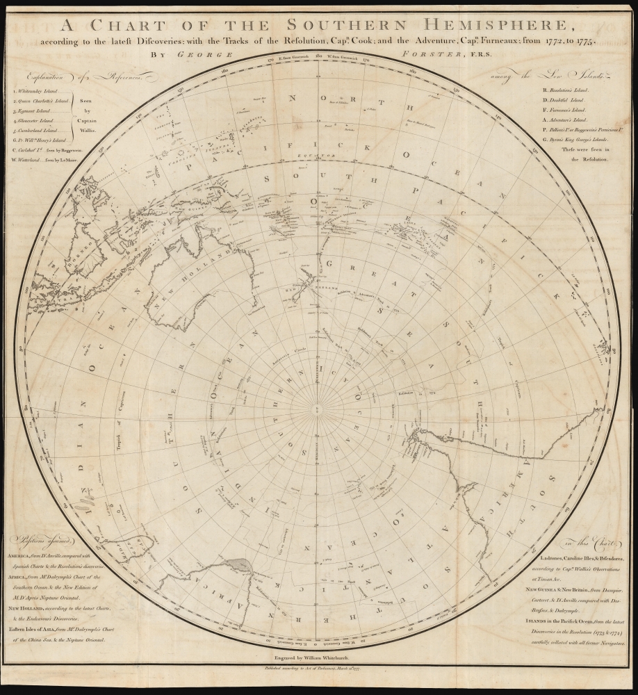
A Chart of the Southern Hemisphere according to the latest Discoveries with the Tracks of the Resolution, Cap.n Cook; and the Adventure, Cap.n Furneaux; from 1772, to 1775.
1777 (dated) 26.25 x 25 in (66.675 x 63.5 cm) 1 : 44000000
1777 (dated) 26.25 x 25 in (66.675 x 63.5 cm) 1 : 44000000
Description
A rare 1777 George Forster map of James Cook's second voyage of exploration to the South Pole, from 1772 to 1775.
The chart is clearly presented and labeled, and is remarkable in its recognition not only of Forster's immediate sources - he, after all, was present during this voyage - but he also cites earlier sources informing his broader choices for framing his chart. Forster credits the maps of D'Anville and Dalrymple, as well as the 1767 discoveries of Captain Samuel Wallis in the South Pacific. He even marks islands charted by the 17th century Dutch mapmakers Le Maire and Roggeveen.
A Closer Look
An oblique polar projection, it is focused on the South Pacific waters in which most of Cook's most significant discoveries occurred: Australia, New Zealand and a large part of the East Indies are included. The southern parts of the African and South American coasts are visible as well. The tracks of the two ships on the expedition - Cook's Resolution, and the Adventure, captained by Tobias Furneaux - are shown, including their southernmost forays. The failures of these to find land there, due to ice fields, are indicated. The map consequently includes no southern continent as no land was discovered.Object and Achievements of the Voyage
The expedition chronicled here is Captain James Cook's second voyage of discovery, from 1772 to 1775. His object - commissioned by the British government - was to circumnavigate the globe as far south as possible in order to determine whether or not the often-theorized southern continent, Terre Australis, existed. While the ships did not discover Antarctica - being prevented from venturing sufficiently southwards by the thick ice floes - Cook was able to debunk speculations of a southern continent in temperate latitudes. The expedition touched Easter Island, the Marquesas, Tahiti, the Society Islands, Niue, Tonga, the New Hebrides, New Caledonia, Norfolk Island, Palmerston Island, the South Sandwich Islands, and South Georgia.The chart is clearly presented and labeled, and is remarkable in its recognition not only of Forster's immediate sources - he, after all, was present during this voyage - but he also cites earlier sources informing his broader choices for framing his chart. Forster credits the maps of D'Anville and Dalrymple, as well as the 1767 discoveries of Captain Samuel Wallis in the South Pacific. He even marks islands charted by the 17th century Dutch mapmakers Le Maire and Roggeveen.
Publication History and Census
This chart was engraved by William Whitchurch for inclusion in Forster's A Voyage Round the World performed in His Britannic Majesty's ships the Resolution and Adventure, in the years 1772, 1773, 1774, and 1775.. The book is well represented in institutional collections, but the chart is listed separately only three times in OCLC, and is scarce on the market.CartographerS
Johann George Adam Forster, also known as Georg Forster (November 27 1754 – January 10, 1794) was a German naturalist, ethnologist, travel writer, journalist, and revolutionary. Born near Gdansk, he was the son of Johann Reinhold Forster, a Reformed Protestant pastor and scholar. Georg from early on expressed interest in the study of nature, in which his father indulged and instructed him. The ten-year-old Georg accompanied his father in travels, commissioned by the Russian government, to inspect German settlements along the Volga, a 2,500 mile journey resulting in the collection of hundreds of specimens of plants for taxonomy. Beginning October 1765, George attended Saint Peter's School in St Petersburg, but this was short lived: his father's report on the settlements was critical of the local Russian voivode, and father and son had to leave Russia without being paid. Their travels took them to London in 1766, where they would settle. Georg's facility with languages was such that at the age of 12 he was able not only to translate Lomonosov's history of Russia into English, but to continue it up to the present. The book was published. His father moved to take up a teaching position at Warrington Academy 1767, while Georg remained in London to apprentice with a merchant until, before joining his father at Warrington to study classics, religion, mathematics, French, and natural history: these two latter taught by his father.
His travels with his father would continue, most notably accompanying James Cook's second voyage to the Pacific, 1772-1775. His report of that journey remains an essential document on the ethnology of Polynesia. His efforts would be recognized with his admittance to the Royal Society at the age of twenty-two.
His return to Europe would signal a shift to academic life. He would hold teaching positions in Kassel, Vilna, and Mainz, whilst continuing to write on botany, ethnology and travel; he produced a German translation of Cook's diaries. An important figure in the German enlightenment, he was an active and influential writer: Alexander von Humbolt considered him the founder of both comparative ethnology and regional geography. He held a leading role in the establishment of the Mainz Republic in 1792, The When the French took control of Mainz in 1792, Forster played a leading role in the Mainz Republic, but was in Paris when Prussian and Austrian forces retook Mainz; Forster was thereafter unable to return and died in Paris of illness in 1794. More by this mapmaker...
William Whitchurch (April 1748 - February 1794) was a British line engraver and printer active in London and Chichester in the second half of the 18th century. Whitchurch was born at St. Andrew Holborn. He apprenticed to the London engraver Joseph Ellis (1734 - c. 1800) from 1762. Whitchurch engraved maps for Cook, Dalrymple, Lerpinière, and others. Learn More...
Captain James Cook (7 November 1728 - 14 February 1779) is a seminal figure in the history of cartography for which we can offer only a cursory treatment here. Cook began sailing as a teenager in the British Merchant Navy before joining the Royal Navy in 1755. He was posted in America for a time where he worked Samuel Holland, William Bligh, and others in the mapping of the St. Lawrence River and Newfoundland. In 1766 Cook was commissioned to explore the Pacific and given a Captaincy with command of the Endeavour. What followed were three historic voyages of discovery, the highlights of which include the first European contact with eastern Australia, the discovery of the Hawaiian Islands (among many other Polynesian groups), the first circumnavigation of New Zealand, some of the first sightings of Antarctica, the first accurate mapping of the Pacific Northwest, and ultimately his own untimely death at the hands of angry Hawaiians in 1779. The influence of Cook work on the mapping and exploration of the Pacific cannot be understated. Learn More...
Source
Cook, Capt. J. / Forster, G., A Voyage Round the World, (London: White) 1777.
Condition
Very good. Trimmed close to left and right just touching border, some faint offsetting, else excellent.
References
OCLC 494686045. Rumsey 3404.002 Tooley, R.V. The mapping of Australia and Antarctica. p. 292, 61A.r