1946 Pictorial Tourist Map of the American Southwest
Southwest-harvey-1946-2$300.00

Title
(Illustrated Map of the Great Southwest Including Points of Interest in New Mexico and Arizona Published by Fred Harvey.)
1946 (dated) 13.25 x 21.25 in (33.655 x 53.975 cm) 1 : 3260750
1946 (dated) 13.25 x 21.25 in (33.655 x 53.975 cm) 1 : 3260750
Description
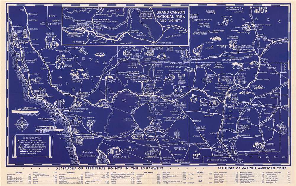
This attractive 1946 pictorial map of the American Southwest was produced by the Fred Harvey Company, the concessioner for the Atchison Topeka and Santa Fe Railroad. The map promotes not only the famous geological attractions of the Southwest, but also 'Harvey Car' cultural tourism to both Native American historic sites and living villages.
Harvey Car Tourism
At its peak, the Fred Harvey Company ran 84 hotels and restaurants along the railway from Topeka to San Francisco, with many locations in Colorado, New Mexico, and Arizona. Later, the company expanded into demonstrations of Native American crafts and 'Indian Detours, which took tourists in private 'Harvey Cars' from rail stops into Indian Country. The present map dovetails with these promotions, combining verso imagery of Navajo and Pueblo artistic motifs with a map detailing attractions.A Closer Look
The white-on-blue printed map spans New Mexico, Arizona, southern Colorado, Nevada, California, and southern Utah. Towns and cities are shown in relation to the Atchison Topeka and Santa Fe Railroad, the Southern Pacific, the Union Pacific, and the Rock Island Line. Throughout are illustrations of regional tourist attractions, ranging from natural features (the Grand Canyon Rainbow Bridge, Carlsbad Caverns) to Native American sites (Hopi Villages, Chaco Canyon, the Painted Desert, Mesa Verde) to modern wonders (Roosevelt Dam, Boulder Dam, and Los Angeles). An inset map details the Grand Canyon National Park. A table at the bottom compares the altitude of the attractions with that of major American cities.Publication History and Census
This blue-printed 1946 edition of the map is scarce. We see eight examples cataloged in institutional collections. Eleven examples printed in the fifties and sixties can likewise be found; later editions are printed in brown rather than blue.Cartographer
Fred Harvey (June 27, 1835 – February 9, 1901) was a British immigrant active in the southwestern United States in the late 19th century. His firm, The Fred Harvey Company was a hospitality chain operating branded restaurants conveniently located (rent-free) along the Atchison Topeka and Santa Fe Railroad. The first Harvey House was opened in Topeka in 1876, and its success led to the opening of more Harvey Houses down the ATSF line, who considered the presence of the Harvey Houses a welcome promotional expense. Through the 1930s, the ATSF funded Harvey ventures throughout Kansas, Colorado, New Mexico, Arizona, and California, ranging from lunch counters to railway newsstands to luxury hotels. Fred’s son Ford took over the chain on Fred’s death in 1901. Ford, an enthusiast of the southwest, incorporated the arts and culture of North American Indians living near the Harvey hotels and restaurants, to attract more travelers to New Mexico and Arizona. They established the Fred Harvey Indian Department in 1901, hiring Indian artist-demonstrators to weave blankets and make pottery and jewelry in an annex of the grand Alvarado Hotel in Albuquerque, New Mexico. The company operated until 1965. More by this mapmaker...
Condition
Good condition. Reinforced at folds with some loss at junctures and extremeties of folds.
References
Rumsey 9062.000. OCLC 191855761.