This item has been sold, but you can get on the Waitlist to be notified if another example becomes available, or purchase a digital scan.
1853 Eastman Map of Hopi / Moqui Pubelos in New Mexico
SouthwestNewMexico-eastman-1853$150.00

Title
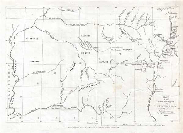
Map of the South western part of New Mexico.
1853 (dated) 8.25 x 11.25 in (20.955 x 28.575 cm) 1 : 3010000
1853 (dated) 8.25 x 11.25 in (20.955 x 28.575 cm) 1 : 3010000
Description
This is an 1853 Seth Eastman map of New Mexico and Arizona focusing on the seven Moqui or Hopi pueblos. The map depicts the region from the Colorado River to the Rio Grande del Norte and the cities of Santa Fe and Taos, New Mexico, and from Utah to the Gila River in Arizona. Numerous different American Indian tribal lands are labeled, mostly in the western part of the map, whereas nearly two dozen settlements, both labeled and unlabeled, line the banks of the Rio Grande. Albuquerque, Taos, and Santa Fe are labeled, along with creeks and rivers that are tributaries of the Rio Grande. Ruined pueblos are indicated along the Chaco river, and both Chaco Canyon and Canyon de Chelly (Ghelly) are also labeled.
This map was drawn by Seth Eastman and engraved by Illman and Sons for inclusion in Henry Rowe Schoolcraft's Information Regarding the History, Conditions, and Prospects of the Indian Tribes of the United States, which was published in six volumes between 1851 until 1857 by Lippincott, Grambo, and Company of Philadelphia.
This map was drawn by Seth Eastman and engraved by Illman and Sons for inclusion in Henry Rowe Schoolcraft's Information Regarding the History, Conditions, and Prospects of the Indian Tribes of the United States, which was published in six volumes between 1851 until 1857 by Lippincott, Grambo, and Company of Philadelphia.
CartographerS
Seth Eastman (January 24, 1808 - August 31, 1875) was a U.S. Army officer, painter, and cartographer. Born in Brunswick, Maine, Eastman was the eldest of thirteen children. He entered the United States Military Academy at West Point, at the ages of sixteen, in 1824 and graduated in 1829 as a second lieutenant in the 1st Infantry Regiment. While at West Point he studied topographic drawing under Robert W. Weir, and employed his skill as an artist throughout his career in the army. In 1830, Eastman was assigned to Fort Snelling, which was located near present-day Minneapolis, in the Minnesota Territory. His tour of duty at Fort Snelling Eastman lasted three years, and while there Eastman learned the Sioux language and painted and sketched many scenes of American Indian life. During this tour of duty, Eastman married Wakan Inajin-win (Stands Sacred), the fifteen-year-old daughter of a Dakotah (Santee Sioux) chief. They had a daughter together in 1832, shortly before Eastman was reassigned from Fort Snelling to teach drawing at West Point. Before leaving he declared his marriage ended, a common practice of European-American men who abandoned Indian women and children. Eastman married the daughter of a West Point surgeon, Mary Henderson, in 1835, with whom he had five children. After seven years at West Point, Eastman was reassigned to Fort Snelling in 1841 and appointed the fort's commanding officer. Eastman is best known for illustrating Henry Rowe Schoolcraft's book entitled Information Regarding the History, Conditions, and Prospects of the Indian Tribes of the United States. He is also known for his paintings, particularly those commissioned by the House Committee on Military Affairs to paint pictures of seventeen important forts. These seventeen paintings were completed between 1870 and 1875, eight of which still hang in the Senate Wing. More by this mapmaker...
Thomas Illman (fl. c. 1824 – 1858) was an English engraver active in New York City during the early 19th century. Illman was born in England and attended Trinity College in Oxford where he attained a degree in theology. Despite initial religious fervor, he soon became an atheist. Professionally he turned to engraving to support his artistic tendencies. In London he mastered the engraver's art. His first paying work as an artist was illustrating for Thomas Carlyle's Confessions of an English Opium Eater. He relocated to New York City in 1828, almost immediately partnering with Edward Pilbrow to found the firm Illman and Pilbrow. Illman and Pillbrow were almost immediately hired by David H. Burr to engrave maps for his Universal Atlas, which he began working on in that year. When Burr took a position as topographer and cartographer for the United States Post Office, he ceded all remaining work on the Atlas to Illman and Pilbrow. In addition to his atlas work, Illman privately pursued his own art as well as engraved portraits and landscapes. He was admired as a skilled line, stipple, and mezzotint engraver. At some point he may have relocated to Philadelphia. His sons, H. Illman and G. Illman followed in his footsteps founding Illman Sons in 1845 Learn More...
Joshua Ballinger Lippincott (March 18, 1813 - 1886) was the founder of J. B. Lippincott and Co. (1836-2002), an American publishing house founded in Philadelphia, Pennsylvania in 1836. Lippincot was born in Juliustown, New Jersey. He relocated to Philadelphia in 1827 where he worked at Clark's Bookstore (1827 - 1836). Clark's went bankrupt in 1836 and in the same year Lippincott started his own company. Meeting with considerable success, in 1849, he acquired the entire stock of the publishing house Grigg, Elliott, and Company. This acquisition positioned Lippincott as the primer publisher in Philadelphia. The next year, 1850, the firm reorganized and took a a new partner, Grumbo, emerging as Lippincott, Grumbo, and Company. In 1855, the partner Grumbo retired and the company name reverted to J.B. Lippincott and Company. He founded Lippincott’s Magazine in 1868 and the Medical Journal a few years later. In 1875, Lippincott founded an agency in London to import European literature into the United States. During his life he was a director of the Reading Railroad, the Philadelphia Saving Bank, the Union League Club, and the Academy of Fine Arts, as well as a trustee of the University of Pennsylvania. His firm became the J. B. Lippincott Company in 1878, and was subsequently acquired by Harper and Row Publishers in 1978. In 1995, Wolters Klumer N.V. of the Netherlands purchased the company, which became Lippincott-Raven Publishers in 1996 and Lippincott Williams and Wilkins in 1998. In 2002, the firm ceased to exist and became Wolters Kluwer Health. Learn More...
Source
Schoolcraft, H. R., Information Regarding the History, Conditions, and Prospects of the Indian Tribes of the United States, (Philadelphia: Lippincott) 1854.
Condition
Very good. Closed tear extending one half inch into printed area from right margin professionally repaired on verso. Blank on verso.
References
Wheat, C. I., Mapping of the Transmississippi West, 1540 – 1861, #781. OCLC 38725150.