1705 De Fer map of Spain and Portugal
Spain-defer-1705$750.00
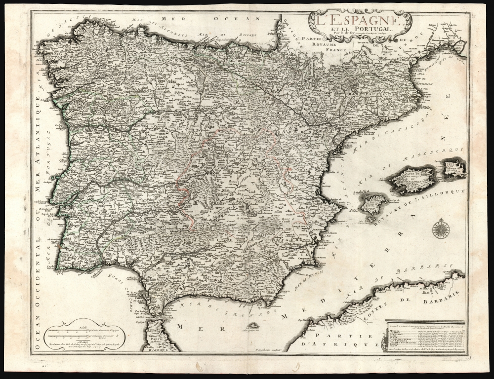

Title
L'Espagne et le Portugal par N. De Fer Geographe de sa Majesté Catolique.
1705 (dated) 18.75 x 24 in (47.625 x 60.96 cm) 1 : 2094760
1705 (dated) 18.75 x 24 in (47.625 x 60.96 cm) 1 : 2094760
Description
This is a beautiful example of Nicholas De Fer's 1705 map of Spain and Portugal, including the Balearic islands and part of the North African coast. Typical of De Fer's work, the map is superbly detailed, while remaining restrained and elegant in its decoration.
A Closer Look
The map's toponymy is granular in detail; rivers are copious and attractively rendered. Mountains are indicated pictorially. The kingdoms of Portugal and Spain are distinguished with engraved borders. Spain is divided into new and old Castille, Andalusia, the kingdoms of Granada and Murcia, Valencia, Catalonia, Navarre, Asturias, and Leon. Three attractive cartouches present the map's title, the map's scales, and a table noting the latitude and longitude of Madrid, Lisbon, Barcelona, Cadiz, Bilbao, the capes of Finisterre and St. Vincent, the strait of Gibraltar, Tangier, and Ceuta.Publication History and Census
This map was separately published in 1705, although it occasionally appeared in later composite atlases. It was published by De Fer from his office on Quai de l'Horloge, Paris, and was engraved by Pieter Starckman. Only a handful of examples have appeared on the market. The map is neglected by institutional collections: we see only three examples listed in OCLC.CartographerS
Nicholas de Fer (1646 - October 25, 1720) was a French cartographer and publisher, the son of cartographer Antoine de Fer. He apprenticed with the Paris engraver Louis Spirinx, producing his first map, of the Canal du Midi, at 23. When his father died in June of 1673 he took over the family engraving business and established himself on Quai de L'Horloge, Paris, as an engraver, cartographer, and map publisher. De Fer was a prolific cartographer with over 600 maps and atlases to his credit. De Fer's work, though replete with geographical errors, earned a large following because of its considerable decorative appeal. In the late 17th century, De Fer's fame culminated in his appointment as Geographe de le Dauphin, a position that offered him unprecedented access to the most up to date cartographic information. This was a partner position to another simultaneously held by the more scientific geographer Guillaume De L'Isle, Premier Geograph de Roi. Despite very different cartographic approaches, De L'Isle and De Fer seem to have stepped carefully around one another and were rarely publicly at odds. Upon his death of old age in 1720, Nicolas was succeeded by two of his sons-in-law, who also happened to be brothers, Guillaume Danet (who had married his daughter Marguerite-Geneviève De Fer), and Jacques-François Bénard (Besnard) Danet (husband of Marie-Anne De Fer), and their heirs, who continued to publish under the De Fer imprint until about 1760. It is of note that part of the De Fer legacy also passed to the engraver Remi Rircher, who married De Fer's third daughter, but Richer had little interest in the business and sold his share to the Danet brothers in 1721. More by this mapmaker...
Pieter Starckman (fl. c. 1680 - 1730), a.k.a Peter or Petrus, was a Dutch engraver active in the late 17th and early 18th centuries. Starckman was likely born in Amsterdam in March of 1655, the son of Steven Starckman and Atalijntge van Oostijnen. During much of his career he was active in the Hague, but some records suggested that in the early 18th century he held a royal appoint in France as Graveur du Roy en Geograpie, Fortifications et Marines. Starckman engraved for numerous cartographers as well as on his own account, usually signing his work as 'P. Starckman'. He collaborated with the finest mapmakers of his day, including De Fer and De L'Isle. Learn More...
Condition
Very good. Filled wormholes in bottom margin. Traces of old color.
References
OCLC 764059891.