1851 Black Map of Spain and Portugal
SpainPortugal-black-1851$100.00

Title
Spain & Portugal.
1851 (undated) 16 x 21 in (40.64 x 53.34 cm)
1851 (undated) 16 x 21 in (40.64 x 53.34 cm)
Description
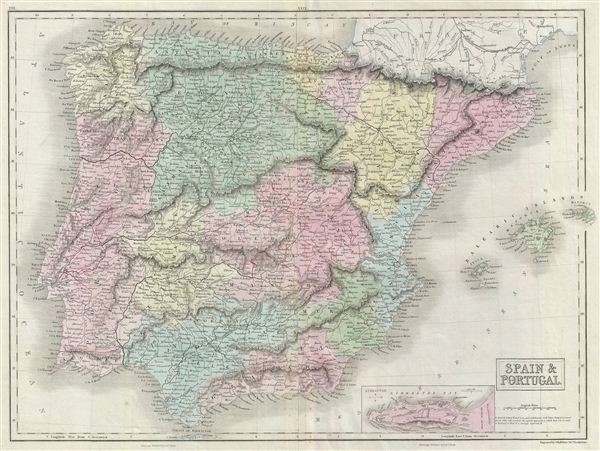
A fine example of Adam and Charles Black's 1851 map of Spain and Portugal. The map covers all of Spain and Portugal from the Pyrenees to the Strait of Gibraltar and includes the Balearic Islands of Ibiza, Majorca, and Minorca. The lower right quadrant features an inset map of Gibraltar. As this map was printed liberal sentiments within Spain were gaining popularity. This eventually led to the Progressive Biennium, in which the Progressive Party tried to replace the conservative liberalism of the Moderate Party with more radical liberalism. Throughout, the map identifies various cities, towns, rivers, lakes, roadways and an assortment of additional topographical details. Map is hand colored in pink, green, blue and yellow pastels to define political and territorial boundaries. The map is engraved by S. Hall and issued as plate no. 30 in Black's General Atlas.
Cartographer
Charles and Adam Black (fl. 1807 - present) were map and book publishers based in Edinburgh. Charles and his uncle, Adam, both of Edinburgh, Scotland, founded their publishing firm in 1807. They published a series of maps and atlases throughout the 19th century. In addition to an array of atlases, the Black firm is known for their editions of the Encyclopedia Britannica (1817 - 1826) and the first publishing of Sir Walter Scott's novels in 1854. In 1889 the A. & C. Black publishing house moved to London where it remains in operation to this day. More by this mapmaker...
Source
Black, A. and C., General Atlas Of The World, (Edinburgh) 1851.
Condition
Very good. Overall toning. Original platemark visible. Minor stains overall. Verso repair along centerfold.
References
Rumsey 2305.035 (1854 edition). Philips (atlases) 4334.