This item has been sold, but you can get on the Waitlist to be notified if another example becomes available, or purchase a digital scan.
1708 Senex Elephant Folio Map of Spain and Portugal
SpainPortugal-senex-1708$375.00

Title
A correct map of Spain and Portugal : according to the newest observations and discoveries communicated to the Royal Society at London and the Royal Academy at Paris…
1708 (undated) 25.5 x 37 in (64.77 x 93.98 cm) 1 : 150000
1708 (undated) 25.5 x 37 in (64.77 x 93.98 cm) 1 : 150000
Description
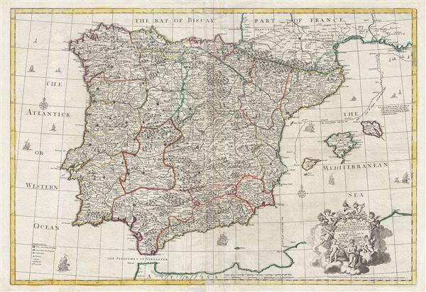
An exception c. 1708 elephant folio (large format) map of Spain and Portugal by the English cartographer John Senex. This enormously proportioned map covers the entirety Iberia from the Atlantic Coast to Minorca and from the Bay of Biscay to the Strait of Gibraltar. Senex includes the Balearic Islands of Ibiza, Majorca, and Minorca. A parallel line running about 1.5 inches east of the Catalan coastline represents Senex's correction on the eastern longitude of Iberia over the earlier maps produced by Sanson and various Dutch cartographers.
This map was drawn and engraved by John Senex in London. It was published by T. Bowles and T. Bowles and Son. The decorative allegorical cartouche in the lower right quadrant was most likely designed and engraved by H. Hulsbergh, but it is not signed. This map was most likely printed in John Senex's Modern Geography; or, All the Known Countries in the World.
This map was drawn and engraved by John Senex in London. It was published by T. Bowles and T. Bowles and Son. The decorative allegorical cartouche in the lower right quadrant was most likely designed and engraved by H. Hulsbergh, but it is not signed. This map was most likely printed in John Senex's Modern Geography; or, All the Known Countries in the World.
CartographerS
John Senex (1678 - 1740) was an English engraver and map maker active in London during the first half of the 18th century. Senex was born to upper middle class parents in Shropshire, England. As a young man, he was apprenticed to Robert Clavell, a London bookseller and member of the Stationers' Company, under whom he mastered the arts of engraving and printmaking. Around 1702 Senex completed his apprenticeship and established himself as a printer and bookseller in the Strand. A year later Senex partnered with Jeremiah Seller and Charles Price, the successors to the important mapmaker John Seller, and relocated to Cornhill. This was likely Senex's first introduction to mapmaking though he seems to have taken to it with abandon. In the subsequent years Senex established himself as one of the most prominent cartographers in London, publishing a number of beautiful and important maps that today rank among the finest examples from the Golden Age of British Cartography. In addition to a large corpus of flat maps, Senex also produced a number of important and highly desirable globes. Eventually Senex dissolved his partnership with Seller and Price and relocated to Fleet Street, where he maintained offices until his death in 1740. Senex was succeeded by his widow, Mary Senex, who continued to publish and update his works until about 1755, when the remaining globe and map plates were sold to James Ferguson. More by this mapmaker...
The Bowles Family (fl. c. 1714 - 1832) were publishers and map sellers active in London from c. 1714 to c. 1832. The firm, under Thomas Bowles (fl. 1714 - 1763), John Bowles (1701 - 1779), Carrington Bowles (1724 - 1793), and as Bowles and Carver (fl. 1794 - 1832), produced a massive corpus of work that included numerous atlases, pocket maps, and wall maps. The Bowles publishing tradition was kept alive for four generations, starting with Thomas Bowles, a print engraver active in the late 17th century. His son, Thomas Bowles II, produced the firm's first maps at St. Paul's Churchyard, London. Thomas's brother, John Bowles (a.k.a. 'Old John Bowles' or 'Black Horse Bowles'), was also an active publisher established at no. 13 Cornhill. He is credited as one of the first publishers of William Hogarth's works. There, John's son, Carrington Bowles, was introduced to the trade. Carrington took over the Cornhill bookshop and eventually merged it with his uncle's shop in St. Paul's Churchyard. On Carrington's 1793 death, the business was passed to his son Henry Carrington Bowles (1763 - 1830), who partnered with his father's former apprentice Samuel Carver (1756 - 1841), renaming the firm 'Bowles and Carver'. Under this imprint, the firm continued to publish maps and atlases until 1832. Henry Carrington Bowles died in 1830, but Samuel Carver, himself in advanced years and poor health, kept it going for another 2 years before closing the business. Learn More...
Source
Senex, John, Modern Geography; or, All the Known Countries in the World, (London) 1725.
Condition
Very good. Minor centerfold wear. Two sheets joined by publisher. Original platemark visible. Blank on verso.
References
OCLC 43214060.