1827 Weiland Map of Spain and Portugal
SpanienPortugal-weiland-1827$250.00

Title
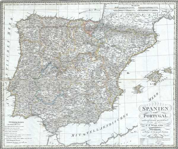
Spanien und Portugal.
1827 (dated) 19 x 23 in (48.26 x 58.42 cm) 1 : 2300000
1827 (dated) 19 x 23 in (48.26 x 58.42 cm) 1 : 2300000
Description
This is a scarce separate-issue 1827 map of Spain and Portugal by C. F. Weiland. It covers the Iberian Peninsula from the Bay of Biscay in the north to the Strait of Gibraltar in the south and from the Atlantic Ocean to Catalonia in the east. The Balearic Islands of Minorca, Majorca and Ibiza and the southern parts of France are also included. The Pyrenees Mountains, the natural boundary between Spain and France, are also identified. Various, important rivers, cities and other topographical details are noted.
During this period, Portugal was on the cusp of the War of the Two Brothers. In 1826, Peter IV of Portugal abdicated his throne in favor of his seven year old daughter Maria da Gloria, on the condition that she marry her uncle (Peter's brother) Miguel. Miguel deposed Maria and proclaimed himself King, which led to the Liberal Wars, eventually resulting in Miguel being forced to abdicate and go into exile, and Maria II being proclaimed Queen. During this same period, in Spain, the death of Ferdinand VII also saw his daughter, Isabella II, an infant at the time, proclaimed Queen. These events set the stage for the First Carlist War in Spain from 1833-1839.
This map was created by C. F. Weiland and published by The Geographical Institute of Weimar.
CartographerS
Carl Ferdinand Weiland (1782 - 1847) was a German cartographer active with the Weimar Geographisches Institut, where he headed up map and globe production, in early and middle part of the 19th century. Weiland was a trained as a military cartographer who, with his career at the Geographisches Institut, move into the private market. Among his other work, Weiland issued a German edition of Carey and Lea's American Atlas. Their edition, which was fully re-engraved in Germany, is of superior workmanship and stands out as some of the finest 19th century maps of individual U.S. states printed outside of America.Carl Ferdinand Weiland (1782 - 1847) was a German cartographer active with the Weimar Geographisches Institut, where he headed up map and globe production, in early and middle part of the 19th century. Weiland was a trained as a military cartographer who, with his career at the Geographisches Institut, move into the private market. Among his other work, Weiland issued a German edition of Carey and Lea's American Atlas. Their edition, which was fully re-engraved in Germany, is of superior workmanship and stands out as some of the finest 19th century maps of individual U.S. states printed outside of America. More by this mapmaker...
Geographisches Institut, Weimar (fl. 1804 - c. 1903) was a German map and globe publishing house and geographical research institute based in Weimar. The organization primarily focused on republishing and improving upon the works of earlier cartographers, including Kitchin, Jefferys, Carey, and others. In general, its publications are known for their fine engraving, attention to detail, historical accuracy, and overall high quality. The firm was founded in 1804 by Friedrich Justin Bertuch (???? - c. 1845) and, on his death, passed to his son Robert Froreip (???? - 1855), then to Louis Denicks of Luneberg, then in 1859 to Voigt & Günther, in 1883 to F. Arnd, from 1890 - 1893 to Julius Kettler, and in 1903 to Max Wedekind. During the institute's height in the early 19th century, most of its cartographic publication was overseen by Carl Ferdinand Weiland (1782 - 1847). The firm also employed the cartographers Franz Xaver von Zach, Adam Christian Gaspari, Heinrich Kiepert, Karl (or Carl) and Adolf Graef, Julius Kettler, Carl Riemer and Karl Christian Bruhns. Weimar was a logical place for a collective like the Geographisches Institut to arise; it was a cultural mecca in the German-speaking world in the late 18th and 19th centuries because of its liberal atmosphere and associations with figures like Schiller, Herder, and, above all, Goethe, who spent most of his adult life in the city. Learn More...
Condition
Very good. Dissected and backed on linen. Minor toning and spotting. Minor wear along fold lines.