
1898 Conkey Map of Philippines and West Indies, Spanish-American War

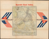
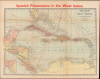
Spanish Possessions in the West Indies. Conkey's Latest Map of the West Indies. / Spanish East Indies.
America Declares Itself a Global Power.
- Digital Map Information
- Suitable for large format printing
- Full resolution TIFF file
- ICC color profile embedded
- Delivered instantly via download link
America Declares Itself a Global Power.
This is the W. B. Conkey Company's 1898 map of the West and East Indies (Philippines), highlighting Spanish possessions. It was prepared in the context of the Spanish-American War (1898), which led to the United States seizing control or oversight of the Philippines, Cuba, and Puerto Rico.A Closer Look
The recto covers the East Indies, centered on the Philippines, Borneo, and Celebes. Shipping lines are traced in black while submarine telegraph lines are marked with dashed lines. The crossed flags of Cuba and the United States appear in the margins, reflecting American support for the Cuban independence movement.The verso map covers the West Indies with colonies color-shaded for distinction. Cities and large towns are labeled, along with waterways, mountains, islands, banks, shoals, and coastal hazards. Black lines trace railways in Cuba, while red lines trace the shipping routes of major passenger and mail steamship companies. An inset at bottom-left covers the western portion of Guatemala and the adjacent part of Mexico. Longitude is measured from Washington, D.C.
The Spanish-American War
The Spanish-American War was fought between Spain and the United States between April 21, 1898, and August 13, 1898. The war started after the USS Maine suffered a massive explosion and sank in Havana Harbor. Tensions had been rising between the two countries for some time, with the U.S. showing support for Cuban independence while Spain claimed Cuba to be a province of Spain. After the fighting ended, the U.S. received the Philippines, Guam, and Puerto Rico, and Cuba became a U.S. protectorate.Publication History and Census
This map was prepared and published by the W. B. Conkey Company in Chicago in 1898 and appeared in the book The Great American-Spanish War Scenes published by Conkey. A similar map titled 'American Possessions in the West Indies' with 'American East Indies' on the verso (OCLC 963868123) was published the same year by Conkey, likely an updated version of the present map for a second printing of The Great American-Spanish War Scenes. The present map is only independently cataloged in the OCLC at the Wisconsin Historical Society and the Library of Congress.Cartographer
Walter Blakesley Conkey (July 13, 1858 - March 5, 1923) was a major book publisher based in Chicago at the turn of the 20th century. Born in Ontario, Canada, he emigrated to the United States as a child, first to Philadelphia and then Chicago, where he arrived in 1872. Conkey's father died when he was young and he worked from a very young age to support his family, embedding an intense work ethic in him. After working for five years learning the printing trade in Chicago, Conkey boldly established his own shop in 1877 at the age of 19. Initially working out of a basement and employing used binding machines, he nevertheless managed to establish himself as the leading bindery business in Chicago, employing 1,500 workers in a purpose-built complex on Dearborn Street in downtown Chicago (the structure, built in 1888, still stands). In the early 1890s, Conkey aggressively expanded into publishing as well as binding, buying up several publishers to become one of the world's most powerful printing and publishing companies. Conkey maintained a special focus on children's and juvenile books, but published in many fields. He also secured a contract for publishing the official catalogue for the 1893 Chicago World's Fair (World's Columbian Exposition), further raising his company's stature. Conkey continued to expand his business, building a massive facility in Hammond, Indiana in 1898, complete with parks, cafeterias, and club rooms for employees. Throughout his career, Conkey was among the fiercest critics of unionism in Chicago, devoting much of his own time and fortune to fighting for an open shop, including serving as president of the Illinois Manufacturers' Association. He nevertheless eventually accepted unionization of his Hammond facility. Conkey died suddenly at his winter home in St. Petersburg, Florida in 1923 at the age of 65. In 1884, he married Chicago native Charlotte Kate Phillips (1859 - 1944), with whom he had three children. Further Details...
Condition
Very good. Light wear along original fold lines. Map of West Indies on verso.
References
OCLC 31816806.