This item has been sold, but you can get on the Waitlist to be notified if another example becomes available, or purchase a digital scan.
1928 Perkins Cyanotype Map of Squam Lake, New Hampshire
SquamLake-perkins-1928$600.00

Title
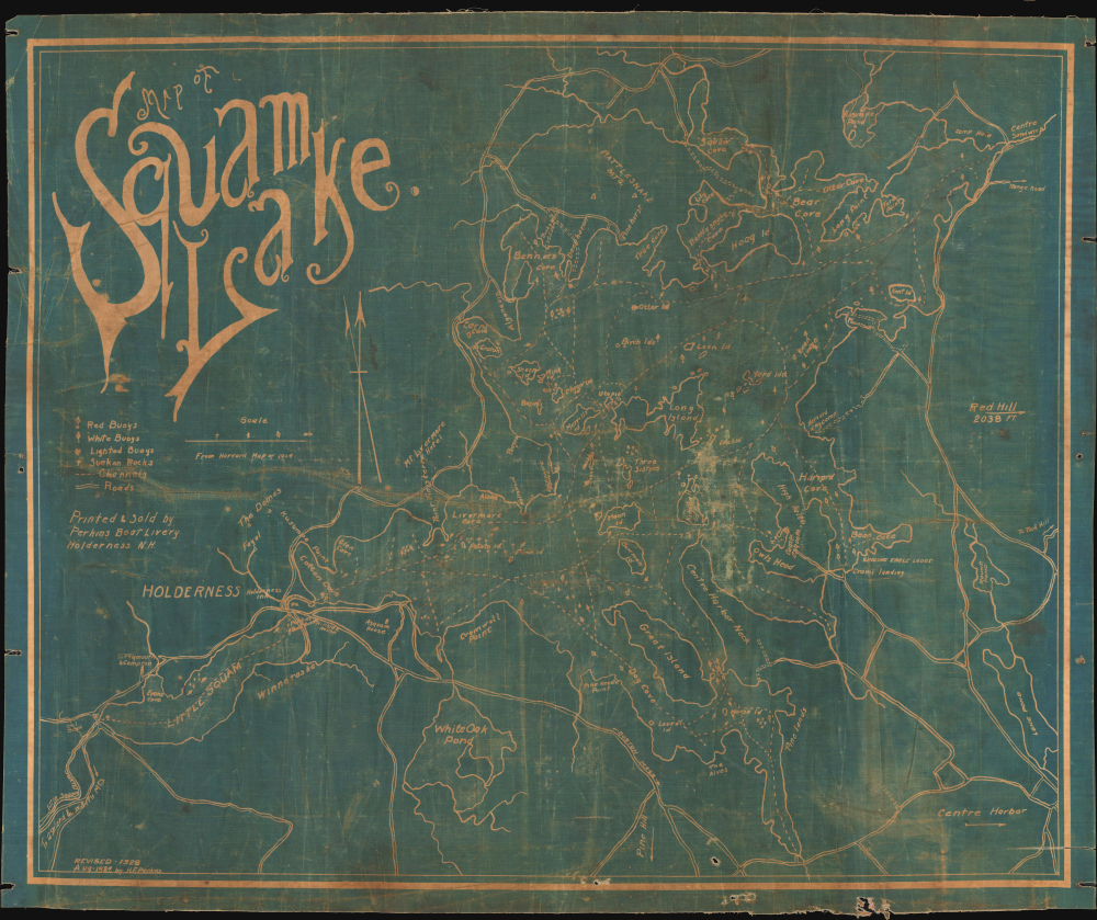
Map of Squam Lake.
1928 (dated) 19.5 x 23.25 in (49.53 x 59.055 cm) 1 : 24500
1928 (dated) 19.5 x 23.25 in (49.53 x 59.055 cm) 1 : 24500
Description
This is an unusual 1928 cyanotype map of Squam Lake in New Hampshire's Lakes Region, prepared by Harold F. Perkins and designed for boaters. The map was issued as Squam Lake emerged as a summertime destination for New York and New England's leisure set.
In any event, the present map was printed and sold by the Perkins Boat Livery. It is printed on waxed linen to keep it dry while boating. We have been unable to locate any other examples of this map in any edition.
A Closer Look
This unusual map covers the Squam Lakes (plural), including the main lake, Little Squam to its southwest, and other nearby bodies of water, which have changed names and shape somewhat since this map's production. For instance, Long Pond at right was later known as Lake Quinebarge or Quinebarge Pond, but is now called Lake Kanasatka. Round Pond to its north is now known as Wakondah or Wakonda Pond. Boating routes across the lake are traced with dashed lines, while islands, islets, hazards, channels, buoys, and other navigational aids are indicated. On land, the location of several camps, hotels, and houses is marked, while mountains and coastal features like points are included for navigational purposes.Picturesque Summertime Scenery
In the 1870s and 1880s, aided by the expansion of railroads, Squam Lake began attracting wealthy families from Boston, New York, and other urban centers seeking escape from the summer heat. These early tourists favored a quiet, unspoiled landscape, and Squam Lake, with its clear waters and forested hills, offered a more serene alternative to the increasingly crowded and commercialized resorts of nearby Lake Winnipesaukee. Early 'rusticators' gave way to travelers seeking more private and pleasant accommodations, and many families began to build cottages and camps along the banks of the lake, as did a group from the Harvard Engineering School (seen at right here). This helped to develop a sense of distinct identity and permanency - despite most residents being seasonal - resulting in the formation of the Squam Lakes Association in 1904. Aside from railroads and accommodations, other industries catered to these travelers, including steamboats and boat rental services, like that offered by the makers of this map.Publication History and Census
This map was prepared by H. F. Perkins, most likely Harold F. Perkins, a member of the family that operated the Perkins Boat Livery in Holderness. The Perkins family had been involved in the burgeoning hospitality industry in Squam Lake since the 1880s, operating cottages and a boat livery service at the site of today's still-operational Squam Boat Livery in Holderness. This map was first produced in 1924, with the present map being a revised 1928 edition. Below the scale is the text 'From Harvard map of 1904,' likely referring to a map produced by or for the Harvard engineers camp. (A 1909 map held by the Harvard Property Information Resource Center, Object No. CA.0147, is titled 'Property of Harvard University at the Harvard Engineering Camp on Squam Lake in the Town of Moultonborough, New Hampshire,' perhaps a later edition of the map referred to here).In any event, the present map was printed and sold by the Perkins Boat Livery. It is printed on waxed linen to keep it dry while boating. We have been unable to locate any other examples of this map in any edition.
Condition
Average. Cyanotype on waxed linen. Edge wear, creasing, minor stabilized tear lower right corner.