
1989 GUGK Historical Map of Volgograd / Battle of Stalingrad, World War II

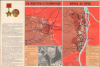
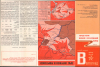
Города - герои Великой Отечественной войны Карты : Волгоград / [Maps of the Hero Cities of the Great Patriotic War : Volgograd]
Commemorating Stalingrad in the Twilight Years of the USSR.
Commemorating Stalingrad in the Twilight Years of the USSR.
This is a 1989 historical map of Volgograd, formerly known as Stalingrad, prepared by the Main Administration of Geodesy and Cartography of the U.S.S.R., better known by the abbreviation of its Russian name as G.U.G.K. It celebrates the costly but heroic Soviet victory over Nazi Germany at the Battle of Stalingrad, the turning point of the war on the Eastern Front and of the entire European theater of World War II (1939-1945). It was also produced at a time when Gorbachev's reforms had allowed for more critical discussion of the war, including the crimes of Stalin and the overwhelming, and in many cases unnecessary, losses suffered by the Soviet people.A Closer Look
This sheet includes three maps on the recto and verso, which depict different stages of the months-long battle for the city: 'On the Approaches to Stalingrad' (На подступах к Сталинграду), 'Battle for the City' (Борьба за город), and, on the verso, 'The Enemy is Surrounded and Destroyed' (Враг окружён и уничтожен). On the recto, the text on the left gives a brief summary of the Battle of Stalingrad and the Soviet counterattack in late 1942 - early 1943. The tone is objective and straightforward, but the authors emphasize the importance of the leadership of the Stalingrad Party Organization (Сталинградской партийной организации) in orchestrating the city's defenses, including factory workers, citizen militia units, Komsomo detachments, and partisan units behind enemy lines. Text on the verso includes a 1965 decree (in red ink) bestowing the Order of Lenin and the Gold Star medal on Volgograd (which had ditched the name Stalingrad in 1961 as part of wider de-Stalinization efforts). Below the decree is a more detailed description of the stages of the battle, statistics for the armies arrayed against each other, and information on the losses sustained by both sides and the city itself, which was almost entirely destroyed and depopulated by the fighting.Historical Context
Following Khrushchev's dismantling of Stalin's personality cult, the Great Patriotic War became a key pillar, perhaps the most important pillar, in the legitimacy of the Communist Party of the Soviet Union to rule the Soviet Union, and no event captured the ultimate triumph over immense suffering and loss more than the Battle of Stalingrad. Fought between August 1942 and February 1943, the Battle of Stalingrad marked the decisive turning point of World War II on the Eastern Front, and of the war overall. Although the Germans had failed to capture Moscow in 1941, they and their allies still fielded a formidable force and occupied most of the agriculturally productive land in the Soviet Union as well as many key urban centers. Initially meant as a side foray in a wider campaign to capture Caucasus oil fields, the fight over Stalingrad increasingly became the focus of German offensive operations, sucking in hundreds of thousands of troops, the vast majority of whom would ultimately be killed or captured. Soviet defenders contested the city street by street, building by building, and sewer by sewer. The battle rapidly devolved into a brutal war of attrition characterized by relentless Luftwaffe bombing, close-quarters combat, and lethal sniper engagements amid the rubble, with civilians often caught in the middle and treated without mercy by both sides. In mid-November 1942, a massive Soviet counter-offensive produced a rapid double envelopment that shattered the weaker Romanian, Hungarian, and Italian troops on the flanks of the German Sixth Army, completely encircling roughly 250,000 Axis troops inside the city. Although Soviet casualties were staggering (over one million killed and wounded, not to mention civilian casualties), these could be easily replaced, while the equivalent number of losses for the Axis forces put them at a permanent disadvantage and on the back foot for the remainder of the war.The commemoration and mythology of Stalingrad were (and remain) a core component of Soviet and, later, Russian national identity (and other post-Soviet national identities), with a symbolic force akin to Valley Forge, Gettysburg, and Omaha Beach combined for Americans. Aside from Stalin, both Khrushchev and Brezhnev went to great pains to emphasize their role in the battle, which was fairly tangential in the former's case and extremely tenuous in the latter's. Mikhail Gorbachev was the first Soviet leader born too late to have participated in the war, though he was deeply affected by it and even lived under German occupation for a spell. Although Soviet citizens remained proud of their country's victory, even amidst the economic malaise of the 1980s, Gorbachev's loosening of controls over thought and the media allowed for some critical assessments of the war, including Stalin's wartime crimes (against Poles, Crimean Tatars, and other groups), the Molotov-Ribbentrop Pact with its secret protocol to divvy up Eastern Europe (which was officially acknowledged by the Soviet government in December 1989), and the strategic ineptitude of Stalin and other party leaders early in the war. However, the present map by a state publisher reflects little of these reassessments, as such discussions took place in the public sphere, over which the Party was rapidly losing any semblance of control.
Publication History and Census
This map was edited by E. V. Aulova (Е. В. Аулова) and V. I. Lamzin (В. И. Ламзин), with V. L. Melnikov (В. Л. Мельников) and L. M. Stepanova (Л. М. Степанова) serving as technical editors. It was published in Moscow by the Main Administration of Geodesy and Cartography (G.U.G.K.) of the U.S.S.R. It was originally prepared in 1982 and published in 1983; the present map is a 'corrected' edition prepared in 1988 and published in 1989. This map is part of a series of maps of 'Hero Cities of the Great Patriotic War' which also included Moscow, Leningrad, and Kiev, among others. We have been unable to locate any institutional examples of this map.Cartographer
Main Administration of Geodesy and Cartography, U.S.S.R. (Главное управление геодезии и картографии, or GUGK; 1939 – 1991) traced its roots to the early years of the Soviet Union, when the Higher Geodetic Administration (Высшее геодезическое управление, VGU) was created to centralize and direct topographic, geodetic, and cartographic work in the new state. However, as a branch office of the Supreme Council of National Economy with limited authority and a small staff, it was unable to achieve these lofty goals. In 1925, VGU was transferred to the State Planning Commission (Gosplan) and underwent several organizational changes, but coordination problems persisted. In 1935, the office was placed under the People's Commissariat for Internal Affairs (NKVD) and, in 1939, renamed the Main Administration of Geodesy and Cartography (GUGK) under the USSR Council of Ministers, a form it would retain until the collapse of the Soviet Union in 1991. With its structure and authority settled, GUGK went on to produce many thousands of maps of the Soviet Union, other territories, and the world in several languages over the course of its existence. The successor to GUGK was the Federal Agency for Geodesy and Cartography (Roskartografiya), which existed from 1991 until 2009, when it was replaced by the Federal Service for State Registration, Cadastre and Cartography (Rosreestr). Further Details...
Condition
Very good. Light wear along original fold lines. Map and text on verso.