This item has been sold, but you can get on the Waitlist to be notified if another example becomes available, or purchase a digital scan.
1886 Huntington Real Estate Plat for part of Panama City (St. Andrews Bay), Florida
StAndrewsBayFlorida-huntington-1886$100.00

Title
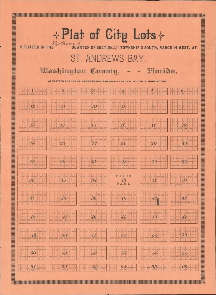
Plat of City Lots situated in the Northeast Quarter of Section 27, Township 3 South, Range 14 West, at St. Andrews Bay, Washington County, - - Florida.
1886 (undated) 18.75 x 13.75 in (47.625 x 34.925 cm)
1886 (undated) 18.75 x 13.75 in (47.625 x 34.925 cm)
Description
An early c. 1886 George S. Huntington real estate plat of part of northeastern Panama City, Florida. The map was issued for the Cincinnati Ohio based Florida land speculation company, St. Andrew Bay Railroad and Land Company.
Economic enthusiasm came crashing down with the Panic of 1893, which devastated the national economy. In Florida, the situation was compounded by severe freezes in 1894 and 1895 that crippled sugar and citrus production. Fledgling towns, plantations, and communities throughout Florida failed, many turning permanently into ghost towns. Disston himself fell into destitution and took up riverboat gambling before committing suicide at 51.
A Closer Look
It is unfortunately unclear exactly which streets in Panama City this plat identifies. From the way the lots are laid out, it is likely oriented to the east, with north to the left - as this reflects the current rectangular layout of Panama City's grid. The St. Andrews Bay Railroad and Land Company promoted its properties aggressively throughout the 1880s into the early 1890s, even resorting to giving away free land in order to draw settlers and develop infrastructure. The effort amounted to little until 1906, when the whole region underwent a population boom was renamed Panama City, after the Panama Canal, which was being built at the time.The First Florida Land Boom (1881 - 1894)
The first major Florida Land Boom can attributed directly to Hamilton Disston (1844 - 1896) and Edward James Reed (1830 - 1906). In enormous debt after the American Civil War (1861 - 1865), Florida legislators came up with a plan to sell off vast tracts of land to private development firms. Much of this fell into the hands of Disston and Reed. Claiming to own 1/3rd of the state, Disston, lured homesteaders and investors with real estate offices across America as well as England, Scotland, Germany, Italy, Sweden and Denmark. He used his political clout to convince presidents, other politicians, and celebrities to vacation in Florida, thus fostering cache and allure. Land prices soared and investors in the United States and abroad were increasingly excited by the prospective gains. Other developers, railroads, and land speculators jumped on board. Luminaries like Henry Ford and Thomas Edison built lavish homes in Fort Meyers.Economic enthusiasm came crashing down with the Panic of 1893, which devastated the national economy. In Florida, the situation was compounded by severe freezes in 1894 and 1895 that crippled sugar and citrus production. Fledgling towns, plantations, and communities throughout Florida failed, many turning permanently into ghost towns. Disston himself fell into destitution and took up riverboat gambling before committing suicide at 51.
Publication History and Census
The map was laid out by George S. Huntington for the St. Andrew Bay Railroad and Land Company. This is the only known example.Condition
Good. Minor reinforcement on verso to some fold intersections and edge splits.