This item has been sold, but you can get on the Waitlist to be notified if another example becomes available, or purchase a digital scan.
1794 Russell Map of Kentucky
StateOfKentucky-russell-1794$500.00

Title
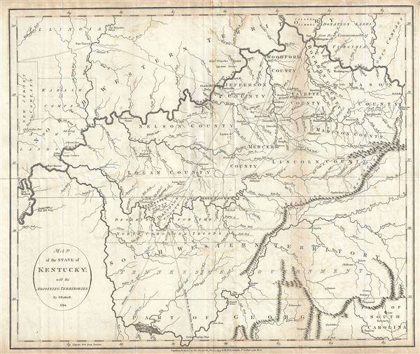
Map of the State of Kentucky; with the Adjoining Territories.
1794 (dated) 15.5 x 18.5 in (39.37 x 46.99 cm) 1 : 1500000
1794 (dated) 15.5 x 18.5 in (39.37 x 46.99 cm) 1 : 1500000
Description
This is an unusual and scarce 1794 map of Kentucky by John Russell. This early map covers all of Kentucky, the northern parts of Georgia, most of Tennessee (here called South Western Territory) and parts of Georgia, Indiana and Ohio (North Western Territory). The towns of Lexington, Louisville, Nashville, Knoxville, etc. are noted. Identifies Leestown, which was the first Anglo-American settlement on the north side of the Kentucky River and is now part of Frankfort. Pioneer roads, called traces, are also identified throughout. The land grants of the New Jersey Companies, Wabash Company, the General Clark's grant, the Ohio Company and Colonel Simmens in the surrounding territories are noted.
This map, issued soon after Kentucky was given statehood and before Tennessee became a state, shows delineated counties within Kentucky. The map was published by H. D. Symonds in William Winterbotham's An historical, geographical, commercial and philosophical view of the American United States, one of the first atlases published after the American Revolutionary War that recognized the United States.
This map, issued soon after Kentucky was given statehood and before Tennessee became a state, shows delineated counties within Kentucky. The map was published by H. D. Symonds in William Winterbotham's An historical, geographical, commercial and philosophical view of the American United States, one of the first atlases published after the American Revolutionary War that recognized the United States.
Cartographer
John Russell (c. 1750 - 1829) was a British cartographer active in London during the late 18th and early 19th centuries. Russell apprenticed as a goldsmith under William Palmer before turning to engraving and printing. He drew maps and engraved for several major publishers of his period including Alexander Dalrymple, Benjamin Henry, Robert Sayer, John Moore, and William Guthrie. Russell's 10 apprentices included such prominent cartographers as Alexander Findlay and Samuel Clapp. Russell was based on Constitution Row Grays Inn Lane, Middlesex (London). More by this mapmaker...
Condition
Very good. Minor wear and toning along original fold lines. Some foxing at places.
References
Rumsey 0845.015 (1795 edition). Library of Congress, Map Division, G3950 1794 .R8.