This item has been sold, but you can get on the Waitlist to be notified if another example becomes available.
1985 Hird Sightseeing Map of Downtown St. Augustine, Florida
StAugustineSightseeing-hird-1985$100.00


Title
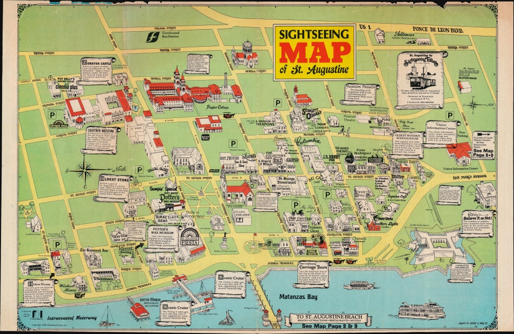
Sightseeing Map of St. Augustine.
1985 (dated) 11 x 16.5 in (27.94 x 41.91 cm) 1 : 7000
1985 (dated) 11 x 16.5 in (27.94 x 41.91 cm) 1 : 7000
Description
A whimsical view of historic downtown St. Augustine, Florida, drawn and published in 1985 by Henry Hird. Characteristic of Hird's work, it combines high and lowbrow elements, including information on local history and advertisements for local restaurants and businesses.
A grid surrounds the map, allowing for easy location of attractions and businesses, as in the advertisements on the verso. A section on local history and a calendar of annual events are also included on the verso.
A Closer Look
Oriented towards the west, this view presents historical downtown St. Augustine, with the oldest Spanish colonial structures near Matanzas Bay in the foreground. These include the Castillo de San Marcos, constructed in the late 17th century, and the Basilica Cathedral of St. Augustine, built in the late Spanish period at the end of the 18th century. The Bridge of Lions, in the foreground, perhaps the most distinctive structure in St. Augustine, was completed in 1927 on the tail end of the Florida land boom. By the end of the 20th century, the bridge suffered from structural problems and had to be considerably renovated, a process completed in 2011.A grid surrounds the map, allowing for easy location of attractions and businesses, as in the advertisements on the verso. A section on local history and a calendar of annual events are also included on the verso.
Publication History and Census
This map was drawn and published by Henry E. Hird III, a local illustrator, in 1985. It pairs with Hird's 'Map of St, Augustine' focusing on the wider region around St. Augustine's historic downtown, also published in 1985. The page numbers referred to suggest that both were part of a larger guide or brochure. Neither map is not known to be held by any institution, though later editions of the sightseeing map are listed in the OCLC (23225878, 844367679).Cartographer
Henry E. Hird III (f. c. 1979 - 2014) was a Florida-based illustrator, photographer, publisher (via his Atlantique Press), and author, best known for his tourist maps of St. Augustine, Florida. He also published postcards of St. Augustine, authored the books Handbook of 50 Pirates and The Complete Guide to St. Augustine, designed and edited the Official Gettysburg National Park Handbook,' and produced drawings for a 2014 exhibit at the St. Augustine Visitor Information Center titled Journey: 450 Years of the African-American Experience, dealing with the history of local African-American communities. More by this mapmaker...
Condition
Good. Chips along the top edge.