This item has been sold, but you can get on the Waitlist to be notified if another example becomes available, or purchase a digital scan.
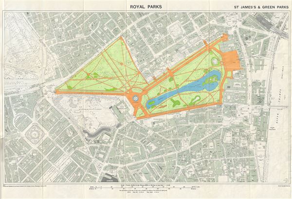
1953 Ordnance Survey Map of the St. James's and Green Parks (Royal Parks), London, England
StJamesPark-ordnancesurvey-1953$50.00

Title
Royal Parks. St. James's & Green Parks.
1953 (dated) 23 x 31 in (58.42 x 78.74 cm) 2.241666667
1953 (dated) 23 x 31 in (58.42 x 78.74 cm) 2.241666667
Description
This is a beautiful example of the 1953 Ordnance Survey map of St. James's Park and Green Park, two of the Royal Parks of London, England. It covers the vicinity of the two adjoining parks from Hyde Park to the River Thames, and south as far as Victoria Station. The map is highly detailed with the parks beautifully rendered. Streets, railway stations, churches, important buildings and other topographical details are noted throughout. Buckingham Palace and its Gardens are also identified. The Royal Parks of London, part of the hereditary possessions of the Crown, were originally owned by the monarchy of the United Kingdom and used for recreation and hunting by the royal family. St. James Park is the oldest and one of the largest parks in London today. Originally believed to have been a burial ground for lepers, Green Park connects with St. James's Park at the Queen Victoria Memorial Gardens. This map was printed and published by the Director General of the Ordnance Survey, Chessington, Surrey in 1953 for the Ministry of Works.
Cartographer
The British Ordnance Survey (1791 - present) is the national mapping agency of Great Britain and is one of the largest producers of maps in the world. This non-ministerial department of the government of the United Kingdom is responsible for producing maps of Great Britain and many of its overseas possessions. The history of the Ordnance Survey goes back as far as 1747, following the Jacobite rising, when King George II commissioned a comprehensive military survey of Scotland to assist further campaigns. The result, produced by Paul Sandby, John Mason and William Roy, was the Duke of Cumberland's Map, the first military quality map of the British Isles. This grew into the Principal Triangulation of Great Britain (1783-1853) under William Roy, and eventually lead to the creation of the Ordnance Survey in 1791. Today the Ordnance Survey produces a large variety of paper maps and digital mapping products. Its large scale maps, issued to the scale of 1:10000, available in sheet map form until the 1980s, are now only available digitally. All maps produced by the Ordnance Survey are in copyright for 50 years after publication. More by this mapmaker...
Condition
Very good. Minor wear along original fold lines. Blank on verso. Folds into original binder.