1981 Jacobs Pictorial Map of St. John, U.S. Virgin Islands
StJohn-jacobs-1981$550.00


Title
St. John Virgin Islands.
1981 (dated) 23.25 x 31.5 in (59.055 x 80.01 cm) 1 : 167000
1981 (dated) 23.25 x 31.5 in (59.055 x 80.01 cm) 1 : 167000
Description
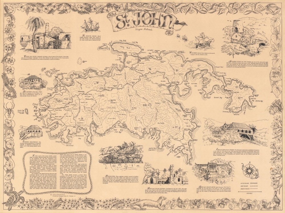
This is a 1981 Deborah Jacobs pictorial map of St. John, U.S. Virgin Islands. Virgin Islands National Park (established in 1956) occupies over half the island, here its boundaries are delineated. Hiking trails, mountain peaks, ruins of former plantations, churches, and other buildings, and roads are illustrated. Contour lines detail topography. Coral Bay, St. John's biggest settlement, and Cruz Bay are labeled, along with coastal points, bays, and other important locations. Pictorial vignettes encircling the central map illustrate the Battery, Caneel Bay Ruins, Annaberg Ruins, Emmaus Moravian Church, Reef Bay Estate House, the Reef Bay Sugar Factory, and the petroglyphs found in Reef Bay Valley. A pictorial border brings the entire piece together and highlights the natural wonders of St. John, focusing on flora and fauna.
Publication History and Census
This map was created and published by Deborah Jacobs in 1981 and printed by Prestige Press on St. Thomas, Virgin Islands. This is the only known cataloged example.Condition
Very good.