This item has been sold, but you can get on the Waitlist to be notified if another example becomes available.
1973 Phillips Map of the St John - Allagash Wilderness, Northern Maine
StJohnAllagashWilderness-phillips-1973$150.00

Title
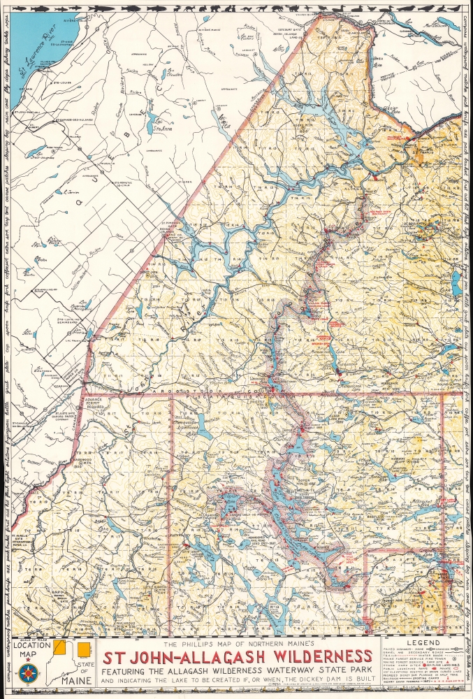
The Phillips Map of Northern Maine's St John - Allagash Wilderness Featuring the Allagash Wilderness Waterway State Park and Indicating the Lake to be Created If, or When, the Dickey Dam is Built.
1973 (dated) 29 x 20 in (73.66 x 50.8 cm) 1 : 240000
1973 (dated) 29 x 20 in (73.66 x 50.8 cm) 1 : 240000
Description
A brilliant juxtaposition of the results of conservation and 'progress', this is a 1973 Augustus D. Phillips and Son map of the St. John - Allagash Wilderness in northern Maine. Phillips highlights the conservation success of the Allagash Wilderness Waterway alongside the potential disaster posed by the Dickey-Lincoln hydroelectric dam project.
A Closer Look
Depicting northwestern Maine from the Quebec border south to Chesuncook Lake and from the Saint Lawrence River east to Fish River Lake, rivers, streams, brooks, lakes, and ponds are all identified by name. Rapids and falls are marked along the St. John River and the Allagash River. Red triangles mark Maine Forest Service campsites and red dashed lines highlight hiking trails. A line of red arrows traces Henry David Thoreau's 1857 trek through the region.A Protected Waterway and a Possible Environmental Calamity
Phillips cleverly juxtaposes the current reality (as of this map's publication) and potential future of the region. In highlighting the Allagash River and the Allagash Wilderness Waterway, Phillips emphasizes the conservation success that the Waterway represents. However, just to the left of the Allagash, Phillips presents the area to be inundated by the construction of the Dickey-Lincoln dam project. In doing so, he subtly provides the viewer with the contrast between protecting one river system and destroying the environment around another.The Allagash Wilderness Waterway
The Allagash Wilderness Waterway was established in 1966 and protects 92.5 miles of lakes, rivers, streams, and ponds, as well as much of the Allagash River, in Maine. Today it is managed as a traditions canoe route, and outboard motor use, motor size, and type of watercraft are all restricted. The Allagash River is part of the National Wild and Scenic River System and was America's first federally protected-state managed Wild river.The Dickey-Lincoln Dam Project
The Dickey-Lincoln Dam project was a series of two hydroelectric dams to be built on the St. John River first proposed and authorized in 1965. The larger of the two dams was set to be built near the town of Dickey, and was first designed to be a 335-foot dam with a 760-megawatt generating station built in town. A second smaller dam was projected to be built 11 miles downstream at Lincoln School, which would have another 70-megawatt plant. The entire project would have flooded 88,000 acres of woodland. The project floundered for twenty years, with the initial cost of $219 million ballooning to over $900 million by the early 1980s. Construction was set to begin in 1983. However, with sportsmen and environmentalists continuing to fight the project, the political will to undertake it finally evaporated and the funding was revoked in 1984.Publication History and Census
This map was created and published by Augustus D. Phillips and Son in 1973. We note three examples cataloged in OCLC which are part of the collections at the Library of Congress, the Osher Map Library at the University of Southern Maine, and the University of Maine at Orono.Cartographer
Augustus Dewey Phillips (May 6, 1898 - December 14, 1975), a.k.a. 'Gus', was an American artist, cartographer, and publisher. Born on Mount Desert Island, Maine, as a boy Augustus and his brother Luther Savage Phillips (1891 - 1960) helped their dad in a variety of odd jobs, including maintaining a boat rental business and harvesting and selling ice. Augustus graduated from Hebron Academy and then attended the University of Maine for a short time. After leaving university, Phillips became a Maine Guide and worked as a carpenter and draftsman in the South Portland and Boothbay Harbor ship and boat yards. The brothers traveled together widely throughout Maine. Luther went on to start a popular map and postcard business out of Northeast Harbor, Maine. After Luther died in 1960, Augustus took over the map businesses. In a tragic turn of events, in 1973 an out of control bush fire destroyed the Phillips studio and much of the surviving stock, making all Phillips' maps issued prior to that date rare. His passion for landscapes helped Augustus create his own map style. Augustus expanded the business and continued making new maps until he died in 1975. Augustus' son, Donald Beekman Phillips (1935 - 2009) continued the business after his father's death. Augustus married Mary Fletcher on April 26, 1922, with whom he had four children. More by this mapmaker...
Condition
Good. Trimmed to border on left and right sides. Substance adhered to recto in upper right quadrant.
References
OCLC 1051780524.