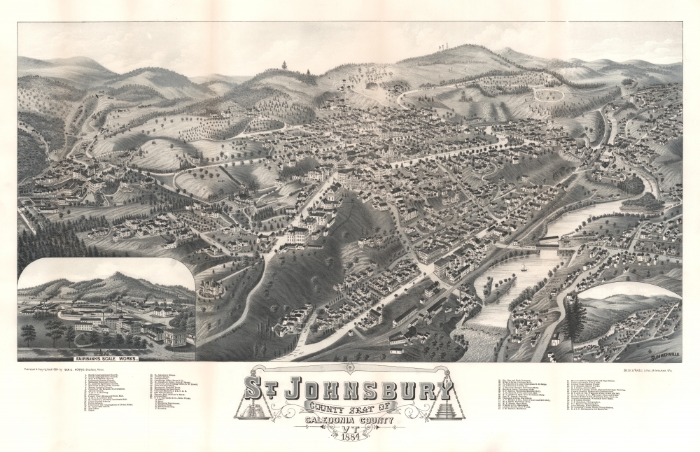
1884 George Norris Bird's-Eye View of St. Johnsbury, Vermont
StJohnsburyVT-norris-1884
Title
1884 (dated) 20.5 x 32.25 in (52.07 x 81.915 cm)
Description
A Closer Look
The view looks northwest over St. Johnsbury with the intersection of Main Street and Eastern Avenue at center. Buildings, streets, and trees throughout the city are illustrated. Fifty-nine locations are numerically identified and correspond with an index below the bottom border. Among these are 10 churches, the Y.M.C.A. building and lecture hall, several schools, the St. Johnsbury Academy, the post office, and nearly three dozen businesses. These include several furniture manufacturers, a lumber mill, a foundry, two photographers, and a florist. The Passumpsic River flows through town from north to south and appears in the foreground. A train from the St. Johnsbury and Lake Champlain Railroad appears just as it is about to cross the river. An inset in the lower left details the Fairbanks Scale Works, the town's largest business whose owner, Franklin Fairbanks, founded the town's superb natural history museum and planetarian. The Green Mountains rise in the distance.American Bird's-Eye City Views
The Bird's-Eye view industry emerged in the United States in the middle part of the 19th century and coincided with the commercial development of lithographic printing. Before the rise of lithography, the ability to own and display artwork in the home was largely limited to the extremely wealthy, but the advent of lithographic printing made it possible for everyone to own visually striking artwork. A robust trade developed in portraits of political leaders, allegorical and religious images, and city views.City views were being produced in the United States as early as the 1830s, but the genre exploded after the American Civil War (1861 - 1865). Bridging the gap between maps and pictures, most 19th-century American bird's-eye views presented cities to the public from high points. Some were imagined, but others were drawn from hot-air balloons or nearby hills. The presentation, combining high elevation, commercial interest, and new printing technology, created a uniquely American art form, as described by historian Donald Karshan,
Some print connoisseurs believe that it was only with the advent of the full-blown city-view lithograph that American printmaking reached its first plateau of originality, making a historical contribution to the graphic arts. They cite the differences between the European city-view prints and the expansive American version that reflects a new land and a new attitude toward the land.The vogue for bird's-eye city views lasted from about 1845 to 1920, during which period some 2,400 cities were thus portrayed, some multiple times. Although views were produced in many urban centers, Milwaukee, Wisconsin, was the nexus of view production in the United States. The major American viewmakers were Stoner, Wellge, Bailey, Fowler, Hill Ruger, Koch, Burleigh, Norris, and Morse, among others.
Publication History and Census
This view was lithographed by Beck and Pauli of Milwaukee, Wisconsin, and published in 1884 by George E. Norris of Brockton, Massachusetts. We note 4 cataloged examples: Library of Congress, Pennsylvania State University, the Boston Public Library, and the California Genealogical Society and Library.CartographerS
George E. Norris (1855 – 1926) was an American hotelier, publisher, and bird's-eye view artist based in Brockton, Massachusetts during the latter part of the 19th century. Norris began publishing views in partnership with Albert F. Poole, an established view maker who, at the time, was renting a house in Brockton from Norris' mother. His first views, most of which were signed by Poole, were published in 1883. In 1884 Norris partnered with Henry Wellge, publishing out of Brockton as Norris and Wellge, and later out of Milwaukee as Norris, Wellge and Co. Norris began drawing views independently around 1887. Most of these were printed by Lucien Burleigh of Troy New York. In total, Norris produced about 135 individual city views. In 1897 he left the view business to open a hotel, the Hotel Norris, in Brockton. Meeting some success in this field, in acquired the Hotel Grayson, also in Brockton, in 1912. He ran this until his death of cerebral hemorrhage in 1926. More by this mapmaker...
Beck and Pauli (fl. c. 1878 – 1889) was a Milwaukee, Wisconsin based lithography firm founded in 1878 by Clemens J. Pauli and Adam Beck. The firm published hundreds of lithograph city views for many of the most prominent viewmakers of the period, including Lucien Rinaldo Burleigh, J. J. Stoner, Henry Wellge, Pauli himself, and others. The company was most active in the mid-1880 until about 1889, when the partners went separate ways and closed the company. Learn More...


