This item has been sold, but you can get on the Waitlist to be notified if another example becomes available, or purchase a digital scan.
1779 Jefferys / Le Rouge Map of St. Kitts and Nevis
StKitts-lerouge-1779$500.00

Title
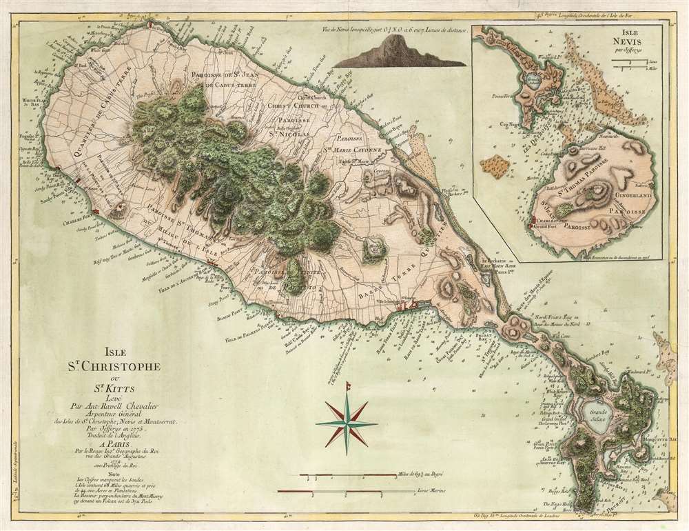
Isle St. Christophe ou St. Kitts Leve Par Ant: Ravell Chevalier Arpenteur Général des Isles de St. Christophe, Nevis et Montserrat. Par Jefferys en 1775. Traduit de l'Anglais A Paris par le Rouge Ingr. Geographe du Roi rue des Grands Augustus 1779 avec Privilege du Roi.
1779 (dated) 18 x 23.75 in (45.72 x 60.325 cm) 1 : 56000
1779 (dated) 18 x 23.75 in (45.72 x 60.325 cm) 1 : 56000
Description
This Anthony Ravell’s survey map of the islands of St. Christopher and Nevis, in its 1779 French translation published by George-Louis Le Rouge. The map is based on the best 18th century survey of the islands, executed by Anthony Ravell, probably in 1717. Ravell's survey of St. Kitts was not committed to print until Jefferys engraved it for Robert Sayer in 1768; Jefferys would produce a further map of the island (combined with an inset map of Nevis) for his 1775 The West-India Atlas. It is this 1775 Jefferys map that Le Rouge copied to produce the present work. While the gap between 1717 and 1779 seems vast to our sensibility, at the time Ravell's survey remained the most current available: consider that the Mount and Page map of St. Christopher, published as late as 1783, was based on the surveys of Andrew Norwood, who died nearly a century prior in 1685. Norwood's survey also provided the source material for maps by Moll, Bowen, and Bellin.
A Bone of Colonial Contention
During the course of the 17th century, the island saw the establishment of colonies by the English (1623) and the French (1625). The two colonial powers vied for dominance, cooperating only in the massacre of the indigenous Kalinago population, and interrupted only for a year by the 1629 Spanish occupation. Thereafter, the English and French partitioned the island, and it changed hands several times through both military action and treaty.A New Survey
As a result of the 1715 Peace of Utrecht, France ceded the entirety of Saint Kitts to Britain. Anthony Ravell, Surveyor General of the Leeward Islands, was tasked to provide up-to-date surveys to the Lords Commissioners. These were submitted in October of 1717, although no printed examples of these are known. The surveys did, nonetheless, make their way Thomas Jefferys, who incorporated them in his 1768 St. Christophers, Surveyed by Anthony Ravell Esqr. published in Robert Sayer's General Topography of North America and the West Indies. Le Rouge's source is not Jefferys' 1768 map but rather his 1775 map, which incorporates a detailed inset map of Nevis, and copious depth soundings and place name changes not evident on Jefferys' earlier work.Division of the Spoils
St. Christopher/ St. Kitts, as administered by the British and the French, was divided roughly between the east and west: The western portion of the Island being British, with a capital at Sandy Point Town, and the eastern part being controlled by the French from Basseterre. All of the maps derived from the Ravell survey show all the European settlements in sufficient detail to distinguish different plantations from one another. Of course, the occasion for the execution of the survey was the passage of the whole of the island to the English. Many of the remarks added to the map reference the Franco-Anglo conflict over the island, both obliquely and directly. The high ground east of Frigate Bay, for example, shows the site of the hill upon which Sir Timothy Thornhill won what was once a famous victory against the French in 1690; fortifications appear throughout the island.Differences between the 1768 and 1775 Jefferys
The two Jefferys maps are not identical. The latter features a coastal view of Nevis, as well as an inset map of the smaller island. The 1775 Jefferys adds depth soundings all around St. Christopher, and adds many place names not present on the 1768. It is not at all clear whether the 1775 incorporates new data added by Jefferys, or if the map is simply a more complete expression of Ravell's surveys. In any case, it is the more detailed 1775 which Le Rouge chose for his model.Arse Hole or Shitten Bay
The island's southeastern peninsula shows a remarkable proliferation of place names, most of which appear to date to the Ravell survey. Frigate Bay, Great Potato Bay (and Little Potato Bay) and White House Bay, for example. Most remarkable of these, arguably, is 'Arse Hole or Shitten Bay.' The 1768 Jefferys only names it 'Arse-Hole Bay,' with the alternate 'Shitten Bay' added for the first time on the 1775 map, which is preserved on Le Rouge's translation. The 1794 Stockdale map of the island dispenses with the first part, naming it only 'Shitten Bay.' The nearby 'Buggs Hole' likewise appears on the maps derived from Ravell. Both of these locations are now popular for snorkeling, but the etymology is unclear. An oral tradition tells that 'Shitten Bay' was the location where slave ships, newly arrived from the middle passage, would stop to clean the slaves prior to their sale in Basseterre. It may be the case that the new place names along the eastern coasts of the island, being applied by the English following the 1702 defeat of the French, were intended to denigrate the former occupiers.Context of the Pilote Americain
In 1778 and 1779, Le Rouge produced his Pilote Americain Septentrional. France was on the verge of entering hostilities in the American Revolution, and so Le Rouge's collection of the best maps of the British colonies in the Americas was timely. Virtually all of the maps in the Pilote Americain were British, the maps of Jefferys figuring especially prominently. Le Rouge's maps were meticulously and scrupulously faithful to the originals, retaining the English notes and providing translations to the French.Publication History and Census
This separate map is scarce; OCLC lists only four examples at the Bibliotheque Nationale de France, the Clements, the University of Bern and the Boston Public Library. Complete examples of the Pilote Americain are catalogued by the California State Library and the Navy Department Library.CartographerS
Georges-Louis Le Rouge (c. 1707 - c. 1790) was a Paris based map publisher operating in the middle part of the 18th century. Le Rouge was born in Hanover Germany as Georg Ludwig, where he was educated and employed as a military engineer and surveyor. His father may have been the French architect Louis Remy de la Fosse (1659 - 1726), which would explain his early education in both engineering and draftsmanship. He assisted his father on a large-scale plan of Darmstadt, which he completed following his father's death in 1726. He may have remained in Darmstadt, but little is known of his life from 1726 - 1736, when he appears in Paris. Le Rouge acquired a position as military and civil engineer for King Louis XV and Louis XVI. Around this time, he Francophied his name to 'Le Rouge'. In 1840, he set up shop on the Rue Des Grands Augustins as an engraver, book publisher, and map publisher. He partnered with the English cartographer and engineer John Rocque (1709 - 1762), who became an important source for English maps, which Le Rouge re-engraved for French use. Despite being born German and adopting Paris as his home, Le Rouge was an ardent Anglophile and spent much of his time translating English books and maps into French. During his active period of roughly forty years Le Rouge produced thousands of maps and diagrams ranging from city and town plans, to atlases, plans of military campaigns and sea charts. He was a friend and correspondent of Benjamin Franklin (1706 - 1790), with whom he produced the important 1769 Franklin/Folger Map of the Gulf Stream. Franklin, who met Le Rouge in Paris, writes that 'He [Le Rouge] is, I believe, a proper person.' He was awarded for his diligence with the impressive but unstipended honorific 'Geographe du Roi'. They may not have served him swell during the French Revolution (1789 - 1799), as his last known work was published in 1789, just before the storming of the Bastille. The exact date of Le Rouge's death remains a mystery. By most estimates, he is believed to have been alive in 1790, but may have lived as long as 1794. More by this mapmaker...
Thomas Jefferys (1695 - November 20, 1771) was one of the most prominent and prolific map publishers and engravers of his day. Jefferys was born in Birmingham and was apprenticed to the engraver Emmanuel Bowen in 1735. Later, in the 1740s he engraved several maps for the popular periodical Gentleman's Magazine. Around 1740 Jefferys was finally able to go into business for himself and in 1746 received an appointment as 'Geographer to Fredrick, Prince of Wales,' which shortly after translated to the position of 'Royal Cartographer to King George III.' Jefferys initially specialized in compiling and re-engraving the works of earlier cartographers into more coherent cartographic wholes. Later, while not salaried position, Jefferys' appointment as 'Royal Cartographer' guaranteed preferential access to the most up to date cartographic material available, allowing him to produce new and updated charts of exceptional accuracy. He his best known for his maps of the Americas, particularly the posthumously published 1775 American Atlas, which included some of the finest and most important late colonial era maps of America ever made. Despite his prolific publishing history, royal appointments, and international publishing fame, Jefferys lived most of his life in dire economic straits. He was bailed out of bankruptcy by Robert Sayer during the production of the American Atlas. In the end, Jefferys died suddenly with very little to his name. Nonetheless, his cartographic legacy survived, and even after his death in 1771, many of his important maps continued to be published and republished by Sayer and Bennet, Conrad Lotter, Georges Louis Le Rouge, Laurie and Whittle, and others. Many attribute some of Jefferys best maps to the colorful and criminally inclined Irish cartographic genius Braddock Mead (John Green, c. 1688 - 1757), who is considered the 'secret behind Jefferys.' Jefferys was succeeded by his son, also Thomas, who had little success as a cartographer and eventually partnered with, then sold his stock and plates to William Faden - Jefferys' true heir. Learn More...
Anthony Ravell (1675 - July 3, 1727) was a British surveyor. He was born in Leicestershire; nothing is known of his education or upbringing. By 1699 he admitted as a surveyor by the Council of Monserrat; he achieved the title 'Surveyor General of the Leeward Islands' with St. Christopher (Saint Kitts), Nevis and Monserrat falling under his purview. He produced a superb map of St. Christopher, which was published by Sayer in 1770, Jefferys in 1775, and thereafter by both Laurie and Whittle and Le Rouge. There is shockingly little information available about this man - He was listed among the subscribers for Pemberton's 1728 A View of Isaac Newton's Philosophy. He died on July 3, 1727 in Saint Kitts. Learn More...
Condition
Very good condition. Fine hand color.
References
OCLC 887574628.