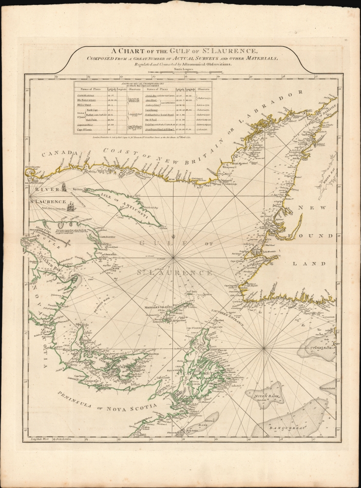
1775 Sayer and Bennett chart of the Gulf of St. Lawrence (with surveys of James Cook)
StLaurence-sayerbennett-1775
Title
1775 (dated) 24.5 x 19.5 in (62.23 x 49.53 cm) 1 : 1480000
Description
A Closer Look
The chart covers the waters from the mouth of the St. Lawrence River in the northwest to the Strait of Belle-Isle in the northeast, and its southeastern opening into the Atlantic Ocean. It thus depicts the southern coast of Quebec from Sept-îles to Red Bay in Labrador and the west coast of Newfoundland from Green Island to the vicinity of Rencontre West. The west shores of the gulf are charted from Grande-Vallée to Cape Breton Island, detailing Chaleur Bay and the peninsula of Nova Scotia as far around as Beaver Harbour. Within the gulf are charted Anticosti Island, Prince Edward Island (here named Island of Saint John), and Cap-aux Meules (named Magdalen Islands on the chart). The chart is replete with depth soundings, shallows, fishing banks, and navigational notes. Two engraved ships illustrate the typical French routes entering and leaving the St. Lawrence River.The Sources
The chart is the result of an initiative by the British Admiralty to better comprehend the coasts and waters that were awarded to Great Britain by the 1763 Treaty of Paris, following the conclusion of the French and Indian War (1754 - 1763). James Cook was promptly sent to survey these waters in April 1763, just two months after the treaty signing - although he already had some familiarity with the region, having taken part in operations against the French there during the war.Sayer and Bennett's map added Cook's surveys - mainly of Labrador and Newfoundland - to an array of preexisting British and French sources, both contemporary and prior to the French and Indian War.
Publication History and Census
This chart was engraved in 1775 for inclusion in Sayer and Bennett's North American Pilot, the production of which had passed to them following the death of Thomas Jefferys in 1771. The chart appeared in subsequent editions of that work, as well as copies of the American Atlas (later editions of this can be distinguished by the addition of 'Pl. No' in the upper right corner accompanying the Roman numeral appearing here; the earliest are identical to that found in the Pilot. The chart is well represented in institutional collections.CartographerS
Robert Sayer (1725 - January 29, 1794) was an important English map publisher and engraver active from the mid to late 18th century. Sayer was born in Sunderland, England, in 1725. He may have clerked as a young man with the Bank of England, but this is unclear. His brother, James Sayer, married Mary Overton, daughter-in-law of John Overton and widow of Philip Overton. Sayer initially worked under Mary Overton, but by December of 1748 was managing the Overton enterprise and gradually took it over, transitioning the plates to his own name. When Thomas Jefferys went bankrupt in 1766, Sayer offered financial assistance to help him stay in business and, in this way, acquired rights to many of the important Jefferys map plates as well as his unpublished research. From about 1774, he began publishing with his apprentice, John Bennett (fl. 1770 - 1784), as Sayer and Bennett, but the partnership was not formalized until 1777. Bennett retired in 1784 following a mental collapse and the imprint reverted to Robert Sayer. From 1790, Sayer added Robert Laurie and James Whittle to his enterprise, renaming the firm Robert Sayer and Company. Ultimately, Laurie and Whittle partnered to take over his firm. Sayer retired to Bath, where, after a long illness, he died. During most of his career, Sayer was based at 53 Fleet Street, London. His work is particularly significant for its publication of many British maps relating to the American Revolutionary War. Unlike many map makers of his generation, Sayer was a good businessman and left a personal fortune and great estate to his son, James Sayer, who never worked in the publishing business. More by this mapmaker...
John Bennett (1746 - December 8, 1787) was an English map publisher. He was born in Derbyshire, the son of Tideswell shoemaker Samuel Bennett. He moved to London around 1761 to take work as a servant to the mapmaker Robert Sayer (1725 - 1794). In 1765, he became Sayer's formal apprentice. Bennett entered the Free Stationers guild on June 7, 1774. Bennett and Sayer continued to work together on the understanding that, in time, Bennett would acquire equity in the firm. This occurred in 1777, when the firm was renamed 'Sayer and Bennett'. For the next several years, they ran one of the most prolific map and printmaking firms in Europe. Bennett began to show signs of mental instability around 1781 and by 1783, was admitted to an asylum in Clapton. The causes are unknown, but mercury poising is a real possibility. Sayer petitioned to dissolve the partnership in 1784 and by 1785 there are no further publications bearing the 'Bennett' imprint. He died in Islington in 1787. Learn More...
Captain James Cook (7 November 1728 - 14 February 1779) is a seminal figure in the history of cartography for which we can offer only a cursory treatment here. Cook began sailing as a teenager in the British Merchant Navy before joining the Royal Navy in 1755. He was posted in America for a time where he worked Samuel Holland, William Bligh, and others in the mapping of the St. Lawrence River and Newfoundland. In 1766 Cook was commissioned to explore the Pacific and given a Captaincy with command of the Endeavour. What followed were three historic voyages of discovery, the highlights of which include the first European contact with eastern Australia, the discovery of the Hawaiian Islands (among many other Polynesian groups), the first circumnavigation of New Zealand, some of the first sightings of Antarctica, the first accurate mapping of the Pacific Northwest, and ultimately his own untimely death at the hands of angry Hawaiians in 1779. The influence of Cook work on the mapping and exploration of the Pacific cannot be understated. Learn More...


