This item has been sold, but you can get on the Waitlist to be notified if another example becomes available, or purchase a digital scan.
1943 Gross Map or Plan of the City of St. Louis, Missouri (and suburbs)
StLouis-gross-1943$97.50

Title
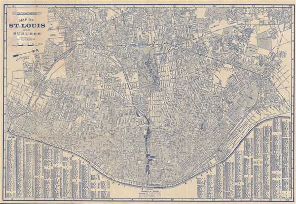
Map of St. Louis and Suburbs.
1943 (undated) 17 x 24.5 in (43.18 x 62.23 cm) 1 : 23000
1943 (undated) 17 x 24.5 in (43.18 x 62.23 cm) 1 : 23000
Description
This is an impressive 1943 pocket map of St. Louis, Missouri, by H. W. Gross. This map, part of the 'City Guide and Map of St. Louis' tourist guide book, is centered on Forest Park and covers central St. Louis from the Mississippi River to the city border just north of the park. It also includes suburban regions to the north, west, and east. A street index appears just below of the Mississippi River at the base of the map. The map is exceptionally detailed and identifies streets, parks, rail lines, important buildings and other topographical features.
This map was published and copyrighted by H. W. Gross.
This map was published and copyrighted by H. W. Gross.
Source
Gross, H.W. 'City Guide and Map of St. Louis'.
Condition
Very good. Backed on archival tissue for stability.
References
OCLC 945571794.