1870 Mitchell City Map or Plan of St. Louis, Missouri
StLouis-mitchell-1870$150.00

Title
St. Louis.
1870 (daed) 14.5 x 11.5 in (36.83 x 29.21 cm) 1 : 32600
1870 (daed) 14.5 x 11.5 in (36.83 x 29.21 cm) 1 : 32600
Description
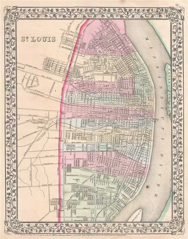
This is an 1870 Samuel Augustus Mitchell, Jr. city map or plan of St. Louis, Missouri. The map depicts the city from outside the city limits to the Mississippi River and from Grand Avenue and Broadway to Keokuk Street. Highly detailed, myriad city streets both inside and outside the city limits are labeled. City wards are shaded different colors for easy differentiation. Individual buildings are labeled throughout the city, including the merchant's exchange, the U.S. Arsenal, a glass factory, and City Hall. The Iron Mountain Railroad is also labeled and runs along the lower left bank of the Mississippi River.
This map was created and published by Samuel Augustus Mitchell, Jr. and published in the 1870 edition of Mitchell's New General Atlas.
This map was created and published by Samuel Augustus Mitchell, Jr. and published in the 1870 edition of Mitchell's New General Atlas.
Cartographer
Samuel Augustus Mitchell (March 20, 1792 - December 20, 1868) began his map publishing career in the early 1830s. Mitchell was born in Bristol, Connecticut. He relocated to Philadelphia in 1821. Having worked as a school teacher and a geographical writer, Mitchell was frustrated with the low quality and inaccuracy of school texts of the period. His first maps were an attempt to rectify this problem. In the next 20 years Mitchell would become the most prominent American map publisher of the mid-19th century. Mitchell worked with prominent engravers J. H. Young, H. S. Tanner, and H. N. Burroughs before attaining the full copyright on his maps in 1847. In 1849 Mitchell either partnered with or sold his plates to Thomas, Cowperthwait and Company who continued to publish the Mitchell's Universal Atlas. By about 1856 most of the Mitchell plates and copyrights were acquired by Charles Desilver who continued to publish the maps, many with modified borders and color schemes, until Mitchell's son, Samuel Augustus Mitchell Junior, entered the picture. In 1859, S.A. Mitchell Jr. purchased most of the plates back from Desilver and introduced his own floral motif border. From 1860 on, he published his own editions of the New General Atlas. The younger Mitchell became as prominent as his father, publishing maps and atlases until 1887, when most of the copyrights were again sold and the Mitchell firm closed its doors for the final time. More by this mapmaker...
Source
Mitchell, S. A., Mitchell's New General Atlas Containing Maps of the Various Countries of the World, Plans of Cities, Etc., embraced in Forty-Seven Quarto Maps, Forming a series of Seventy-Six Maps and Plans, together with Valuable Statistical Tables (Philadelphia: S. Augustus Mitchell, Jr.) 1870.
Condition
Very good. Closed margin tears professionally repaired on verso. Some foxing. Blank on verso.
References
Rumsey 0579.037 (1868 edition).