
This item below is out of stock, but another example (left) is available. To view the available item, click "Details."
Details
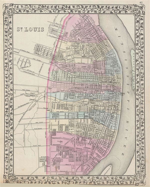
1870 Mitchell City Map or Plan of St. Louis, Missouri
1870 (daed) $150.00
1872 Mitchell Map or Plan of St. Louis, Missouri
StLouis-mitchell-1872$75.00

Title
St. Louis.
1872 (dated, but date cut off) 15 x 12.5 in (38.1 x 31.75 cm)
1872 (dated, but date cut off) 15 x 12.5 in (38.1 x 31.75 cm)
Description
A beautiful example of the legendary American map publisher Samuel Augustus Mitchell Jr.'s 1872 map or plan of the city of St. Louis, Missouri. The map covers the city from Taylor Avenue outside city limits to the Mississippi River and from Augusta to Keokuk Street. In addition to all major streets, this map identifies the U.S. Arsenal, Lafayette Square, the new reservoir, the Fair Ground, and Bloody Island, as well as Arsenal Island across the Mississippi. The map offers extraordinary detail at level of individual streets and buildings. Map is color coded according to city wards. Features the vine motif border typical of Mitchell maps from the 1866 - 1882 period. Prepared by S.A. Mitchell for inclusion as plate nos. 42 in the 1872 issue of Mitchell's New General Atlas. Dated and copyrighted, 'entered according to Act of Congress in the Year 1872 by S. Augustus Mitchell in the Office of the Librarian of Congress at Washington
Cartographer
Samuel Augustus Mitchell (March 20, 1792 - December 20, 1868) began his map publishing career in the early 1830s. Mitchell was born in Bristol, Connecticut. He relocated to Philadelphia in 1821. Having worked as a school teacher and a geographical writer, Mitchell was frustrated with the low quality and inaccuracy of school texts of the period. His first maps were an attempt to rectify this problem. In the next 20 years Mitchell would become the most prominent American map publisher of the mid-19th century. Mitchell worked with prominent engravers J. H. Young, H. S. Tanner, and H. N. Burroughs before attaining the full copyright on his maps in 1847. In 1849 Mitchell either partnered with or sold his plates to Thomas, Cowperthwait and Company who continued to publish the Mitchell's Universal Atlas. By about 1856 most of the Mitchell plates and copyrights were acquired by Charles Desilver who continued to publish the maps, many with modified borders and color schemes, until Mitchell's son, Samuel Augustus Mitchell Junior, entered the picture. In 1859, S.A. Mitchell Jr. purchased most of the plates back from Desilver and introduced his own floral motif border. From 1860 on, he published his own editions of the New General Atlas. The younger Mitchell became as prominent as his father, publishing maps and atlases until 1887, when most of the copyrights were again sold and the Mitchell firm closed its doors for the final time. More by this mapmaker...
Condition
Very good. Minor overall toning. Blank on verso.
References
Rumsey 2483.033 (1870 edition).