This item has been sold, but you can get on the Waitlist to be notified if another example becomes available, or purchase a digital scan.
1844 Blunt Map or Chart of Gulf Coast from Mississippi River Delta to St. Marks, Florida
StMarkstoMississippi-blunt-1865$2,500.00

Title
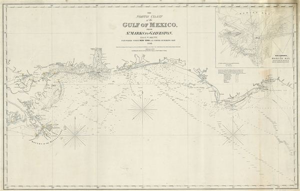
The North Coast of th Gulf of Mexico from St. Marks to Galveston.
1865 (dated) 26 x 41.5 in (66.04 x 105.41 cm)
1865 (dated) 26 x 41.5 in (66.04 x 105.41 cm)
Description
An extremely scarce 1865 nautical chart or maritime map of the Gulf Coast by e and G. W. Blunt. This map, though titled ‘From St. Marks to Galveston' in fact only follows the coast from St. Marks to the Delta of the Mississippi River – suggesting that a companion piece may have been planned for future updates. The Blunts first issued this chart in 1842 with several updated editions following – the present example being the 1865 edition. The map offers excellent coastal detail and countless depth soundings throughout. A detailed inset in the upper right quadrant focuses on the ‘Bar and entrance of Mobile Bay.' A fine and scarce example of this beautiful nautical chart.
Cartographer
Edmund March Blunt (June 20, 1770 - 1862) was an American navigator, bookseller, chartmaker, and cartographer based in Newburyport, Massachusetts. Blunt was born in Portsmouth, New Hampshire in 1770. In 1796, along with the nominal assistance of prominent navigator Captain Lawrence Furlong, Blunt published The American Coast Pilot, one of the most important published works on American navigation. Although much of the work was plagiarized from British publications, the Coast Pilot was an immediate popular success. In response to the popularity of his work, Blunt published 21 subsequent editions, each with important updates and revisions. The first edition to contain map plates was printed in 1804. Following a fire that destroyed his offices at The Sign of the Bible in 1811, Blunt moved his business to New York and opened a new shop, The Sign of the Quadrant. His sons Edmund Jr. (1799 - 1866) and George William (1802 - 1878), joined the firm in 1824 and eventually took over the family business, renaming the firm 'E. and G. W. Blunt'. They both produced their own nautical books, charts, and instruments, as well as republished their father’s work. In 1830, Edmund accepted a position under Ferdinand Hassler at the United States Office of the Coast Survey. Much of Blunt's original work eventually found its way into U.S. Coast Survey Publications. George closed the firm in 1872 and sold the plates and chart copyrights to the U.S. Coast Survey and the U.S. Navy Hydrographic Office. Due to the quality and detail of Blunt's work, revised editions of his most important charts were republished well into the 1880s. More by this mapmaker...
Condition
Very good. Some warping and minor discolorations.