1842 Szontagh Manuscript City Plan or Map of Stockholm, Sweden
Stockholm-szontagh-1842$2,000.00

Title
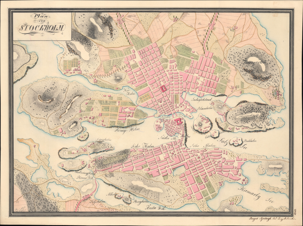
Plan von Stockholm.
1842 (dated) 15.375 x 20.625 in (39.0525 x 52.3875 cm) 1 : 17500
1842 (dated) 15.375 x 20.625 in (39.0525 x 52.3875 cm) 1 : 17500
Description
This is August Szontagh's remarkable 1842 manuscript map of Stockholm, Sweden. The map captures Stockholm during a period of expansion and civic infrastructure reform. Though likely academic rather than administrative, this plan exhibits the meticulous style we've come to associate with military engineering draftsmanship.
The map covers from the modern districts of Norrmalm, Vasastan, and Östermalm, famous for their parks and late 19th-century architecture, southwards to the Årstaviken and Hammarby Sjö, westward to include the entire island of Kungsholmen, and eastward to include the islands of Djurgården. The elevation is indicated by hachure, with terrain shaded to indicate nature and use (buildings, farms, forests, gardens, etc.). Streets and city blocks are neatly traced, while country roads, paths, and bridges are similarly marked out. Several features throughout the map are labeled, mostly islands, islets, and waterways. Several buildings are easily recognizable from their location and shape, such as the Royal Palace (Kungliga Slottet) and the historic Kastellet Stockholm.
Not long after this map's publication, however, both Stockholm and Sweden underwent significant changes. Stockholm, in particular, embraced industrialization with railroads, factories, and modern infrastructure, as well as a comprehensive city plan in 1866, inspired by the same ideas that drove Haussmann's renovation of Paris. Large portions of the city, especially the Klara district in Norrmalm, were radically transformed, and by the end of the 19th century, they would hardly resemble the city seen here.
In any event, the map does not closely resemble any of the major contemporaneous printed maps of the city, taking in a wider perspective than usual that includes the city's hinterland (for comparison, see the more than 100 maps listed in the category page in the Wikimedia Commons titled '19th-century maps of Stockholm'). The lack of a stated scale, the idiosyncratic appearance of some of the city's islands and features, and the atypical inclusion of hachures to denote elevation all suggest that Szontagh made a completely new map rather than hand copy an existing printed map, though he almost certainly consulted published maps in the preparation of the present one. In any event, as a manuscript map, this work is entirely unique.
A Closer Look
This intricately detailed and expertly drawn manuscript map is so well done that it appears at first glance to be a copperplate print. It is even more noteworthy for being a purely sui generis work rather than a hand copy of an existing map.The map covers from the modern districts of Norrmalm, Vasastan, and Östermalm, famous for their parks and late 19th-century architecture, southwards to the Årstaviken and Hammarby Sjö, westward to include the entire island of Kungsholmen, and eastward to include the islands of Djurgården. The elevation is indicated by hachure, with terrain shaded to indicate nature and use (buildings, farms, forests, gardens, etc.). Streets and city blocks are neatly traced, while country roads, paths, and bridges are similarly marked out. Several features throughout the map are labeled, mostly islands, islets, and waterways. Several buildings are easily recognizable from their location and shape, such as the Royal Palace (Kungliga Slottet) and the historic Kastellet Stockholm.
Historical Context
Although Sweden had been one of the great European powers of the 17th and early 18th centuries, it was heavily impacted by its loss in the Great Northern War (1700 - 1721), being supplanted by Russia and, to a lesser extent, Prussia as the major powers in northern Europe. In one respect, the war had a beneficial impact in that it temporarily empowered the parliament vis-à-vis the monarchy, leading to the era after the Great Northern War being dubbed the Age of Liberty. However, economically and demographically, Sweden was falling far behind; some early industrial ventures were launched, but the economy remained overwhelmingly agricultural. Influenced by developments elsewhere in Europe, Sweden shifted towards absolute monarchy under Gustav III (r. 1771 - 1792) but was incapable of fending off a French invasion, a coup d'état, and the loss of Finland to Russia in the course of the Napoleonic Wars (1803 - 1815).Not long after this map's publication, however, both Stockholm and Sweden underwent significant changes. Stockholm, in particular, embraced industrialization with railroads, factories, and modern infrastructure, as well as a comprehensive city plan in 1866, inspired by the same ideas that drove Haussmann's renovation of Paris. Large portions of the city, especially the Klara district in Norrmalm, were radically transformed, and by the end of the 19th century, they would hardly resemble the city seen here.
Publication History and Census
This map was drawn by one August Szontagh and is dated 1842. Szontagh's identity is a mystery; he presumably was a German-speaker as that is the language of the map, and he gives himself the title 'burgakademiker,' which suggests an official scholarly position. But we have been unable to identify any historical sources with a person by this name and title, though an 1875 issue of the weekly publication Fremden-Blatt issued in Vienna refers to 'Oberst August Szontagh' attending an anniversary celebration for an infantry regiment stationed in Lemberg (Lviv). In this case, perhaps Szontagh was an Austrian infantry officer who had prepared this map during a sojourn in Stockholm.In any event, the map does not closely resemble any of the major contemporaneous printed maps of the city, taking in a wider perspective than usual that includes the city's hinterland (for comparison, see the more than 100 maps listed in the category page in the Wikimedia Commons titled '19th-century maps of Stockholm'). The lack of a stated scale, the idiosyncratic appearance of some of the city's islands and features, and the atypical inclusion of hachures to denote elevation all suggest that Szontagh made a completely new map rather than hand copy an existing printed map, though he almost certainly consulted published maps in the preparation of the present one. In any event, as a manuscript map, this work is entirely unique.
Condition
Excellent.