This item has been sold, but you can get on the Waitlist to be notified if another example becomes available, or purchase a digital scan.
1790 Chudjakov Map of St. Petersburg / Schlepper Map of St. Petersburg Environs
StPetersburg-chudjakovschlepper-1790$875.00

Title
Plan der Kayserlichen Residenz Stadt St. Petersburg. / Charte vom St. Petersburgischen Gouvernement nach dessen jetzigen.
1790 (dated) 17.35 x 35 in (44.069 x 88.9 cm) 1 : 41500 / 1 : 700000
1790 (dated) 17.35 x 35 in (44.069 x 88.9 cm) 1 : 41500 / 1 : 700000
Description
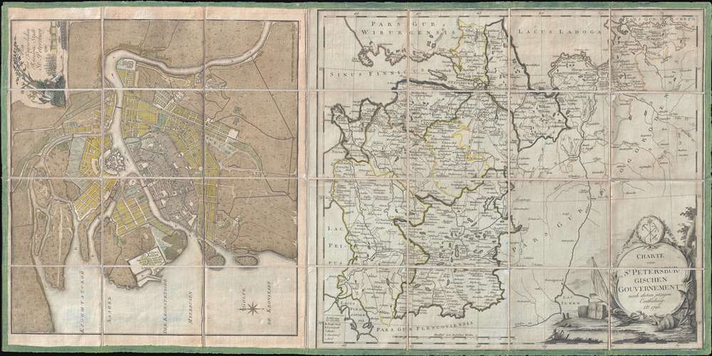
This is a 1790 Efim Maksimovič Chudjakov city map or plan of St. Petersburg and a 1790 I.D. Schlepper map of the environs of St. Petersburg.
The Chudjakov map depicts the city from the Bolshaya Nevka Neva south past the Reka Bol'shaya River and from Neva Bay, also known as the Gulf of Kronstadt, to the Neva River. Highly detailed, over one hundred twenty locations are numerically identified, though unfortunately the corresponding index is not present. The Peter and Paul Fortress is illustrated in detail along the Neva River.
The Schlepper map depicts the region surrounding St. Petersburg from Lake Ladoga to Lake Ilmen and Lake Peipus and from the Gulf of Finland and Lake Peipus to Kapizkoi, northeast of Novgorod. Highly detailed, myriad cities, towns, and villages are labeled throughout, including St. Petersburg and Novgorod. Different counties are outlined in different colors to allow for easy differentiation. Roads are illustrated, as are rivers and lakes.
In 1790, Catherine the Great was entering the last years of her reign, having ruled as the Empress of Russia since 1762. Known as the Catherinian Era, this is considered to be the Golden Age of Russia. An age of Russian expansion, Catherine reigned from the Winter Palace in Saint Petersburg, and oversaw an era in which Russia became recognized as one of the great powers of Europe.
These two maps are dissected and mounted on one piece of linen. Both are extremely rare. The Bayerische StatsBibliothek in Munich has an example of both of these stunning maps, while the National Library of Russia in St. Petersburg only has a copy of the Schlepper map of the environs of St. Petersburg. We have also been unable to locate a record of these maps entering the private market.
Cartographer
Efim Maksimovič Chudjakov (1748-1822) was a Russian cartographer and engraver active in the late 18th and early 19th centuries. Based in Saint Petersburg, Chudjakob was affiliated with the Saint Petersburg Academy of Sciences and is recognized for his remarkable and expansive 1776 map of Russia. More by this mapmaker...
Condition
Very good. Two maps joined. Dissected and mounted on linen in 28 panels. Blank on verso.
References
OCLC 164587531. OCLC 164587532. National Library of Russia 010112843.