This item has been sold, but you can get on the Waitlist to be notified if another example becomes available, or purchase a digital scan.
1908 Titcomb City Urban Planing Map of St. Petersburg, Florida
StPetersburg-titcomb-1908$3,250.00


Title
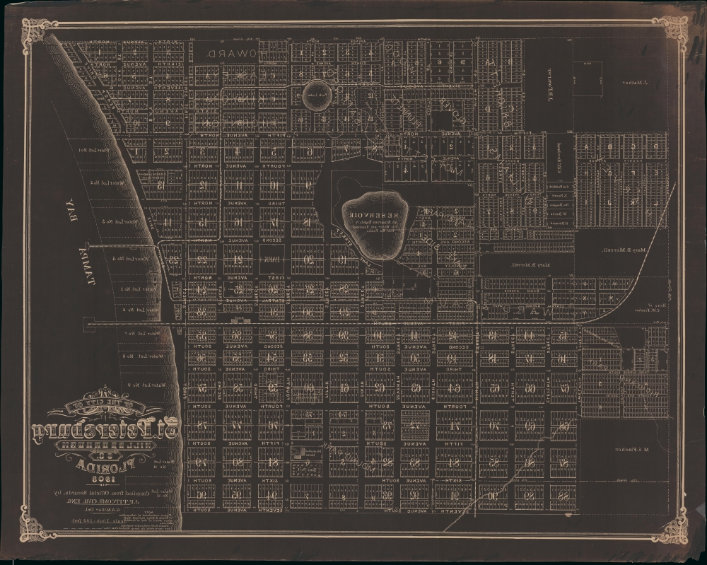
Map of the City of St. Petersburg Hillsborough Co. Florida 1906.
1908 (dated) 38 x 49 in (96.52 x 124.46 cm) 1 : 2400
1908 (dated) 38 x 49 in (96.52 x 124.46 cm) 1 : 2400
Description
An extraordinary 1908 wall map of St. Petersburg, Florida, issued at the height of its early 20th century development as a railroad and tourist town. The only other known example of this map is a 1906 edition previously offered by Geographicus (StPetersburg-titcomb-1906). The present map features several major updates, including the additional developments of Lake Park, Lake Side, Richland Park, Glover, Plunket, and a row of commercial properties on First Street. The sewage lines, evident on the 1906 edition, are here removed to focus on other development.The map was drawn by St. Petersburg's City Engineer, John Poore Titcomb, who took the position in 1901.
A Closer Look
The map is printed in reverse negative, an artifact of the cyanotyping process. The map loosely follows in style if not content, with significantly broader coverage reflecting early 20th century growth, upon the G. A. Miller and A. L Hunt map of 1888 - considered the first map of St. Petersburg. Coverage here embraces from Ninth Avenue North to Seventh Avenue South, and from the city limits at Sixteenth Street to Tampa Bay. The map centers on the Reservoir, the reserved area around which is today's Campbell Park. Private real estate development is noted throughout, with developers named: Moffett, William Kinyon and Wood, Harvey, Pomroy, Mater, Howard, Fischer, and Brickett, among others.St. Petersburg - Historical Context
St. Petersburg, Florida, was founded in 1888, and Orange Belt Railway chose the site as its terminus the same year. It was subsequently incorporated as a town in 1892, with a population of 300. By 1903, when it was incorporated as a city, it was fast developing into one of Florida's major centers. The first decade of the 20th century saw massive investment in infrastructure, including electrified rail lines, city parks, a sewer system, and major port - nearly all of which was guided by Titcomb. The Orange Belt Railway made it one of the few cities in South Florida easily accessible by rail - and as such, it developed early as a tourism destination, with grand hotels and luxurious summer residences. By 1910, the population reached more than 10,000.Cyanotype
Although this map is in black and white, it is nonetheless a variant on the cyanotype process. Cyanotype is a photo-reprographic technique developed in 1842 by the British astronomer John Herschel (1792 - 1871). Sometimes called a 'sunprint', the technique employs a solution of ferric ammonium citrate and potassium ferricyanide, which painted on white paper or cloth, reacts when exposed to sunlight to dye the object a brilliant blue (or sometimes black depending on the chemical formulations). Areas blocked from ultraviolet exposure remain undyed and white. Herschel developed the technique to reproduce his astronomical notes, but others quickly realized that any object capable of blocking light could be used to create a cyanotype image quickly and easily. By the late 19th century, the process became popular with designers, military, architects, and engineers (blueprints), who used the cheap and effective technique to quickly and exactly reproduce images in the field. Cyanotyping is limited in that only a single copy can be made at one time, so it was only practical for short-term field work. It is also of note that cyanotypes remain reactive to light and, over time, can fade or degrade, making them extremely ephemeral. The process fell out of fashion in most places by the 1920s but remains in use in some parts of the world, such as India and Nepal, to this day.Publication History and Census
This is the only known example of the present map, in its 1908 edition. The present example came from Titcomb's estate.Cartographer
John Poore Titcomb (April 7, 1861 - June 26, 1932) was a civil engineer active in Florida and later Maine in the late 19th and early 20th century. Titcomb was born in West Newbury, Massachusetts. In both 1885 and 1886 he received homestead patents in Florida, near Lake Kerr, and in 1887, he appears in the Jacksonville city directory as a Civil Engineer. Similarly, in 1887, we see an advertisement for his services as a Notary and Civil Engineer in the Palatka Daily News. There he promotes his skill with the 'Blue Process' of map reproduction. He married Mary B. Todd (1868 - ????) in 1891. In this same year he was doing railroad and real estate surveys in and around Amesbury. Titcomb likely gave up these grants following the great freezes of 1894 - 1895, which devastate the Florida citrus industry. From 1892, until about 1899, Titcomb served as the City Engineer for St. Petersburg, Florida. Around 1900, he relocated to Amesbury, Massachusetts, where he was active as a surveyor and in the local Masonic lodge. It is likely he spent his winters in St. Petersburg and retained real estate interests there throughout this period. Sometime in the 1920s he appears on voter rolls in California, but he must have returned to Amesbury, as he died there in 1931. More by this mapmaker...
Condition
Very good. Printed in negative. A few large closed, repaired, and stabilized tears.