This item has been sold, but you can get on the Waitlist to be notified if another example becomes available, or purchase a digital scan.
1900 Royal Geographical Society Map of the Strachey Bros. Treks in Tibet
StracheyTibet-rgs-1900$125.00

Title
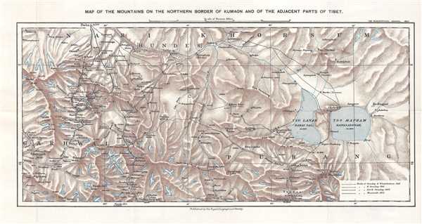
Map of the Mountains on the Northern Border of Kumaon and of the Adjacent Part of Tibet.
1900 (dated) 9.25 x 18.25 in (23.495 x 46.355 cm) 1 : 500000
1900 (dated) 9.25 x 18.25 in (23.495 x 46.355 cm) 1 : 500000
Description
This is a 1900 Royal Geographical Society map tracing the three surveying expeditions mounted by Sir Henry Strachey, his brother, Sir Richard Strachey, and J. E. Winterbottom, despite the longstanding prohibition on the entry of Europeans into Tibet by Tibetan authorities. The map depicts the region from Jyotirmath (Joshimath), India to Lake Manasarovar in the Tibet Autonomous Region of China and from Daba, China to Trisul, India, a group of three Himalayan mountain peaks in western Kumaun. The first expedition was carried out in 1846 by Henry Strachey on his own and he surveyed the regions around Lakes Manasarovar and Rakshastal. It was on this first expedition that Strachey found a channel between Lake Manasarovar and Lake Rakshastal, which suggested that Manasarovar was the source of the Sutlej River, and not Rakshastal. Strachey's brother, Sir Richard Strachey, and J. E. Winterbottom mounted the second expedition into the region in 1848 and continued Henry's exploration of the lakes and the surrounding region. The third excursion illustrated on the map was undertaken by the Strachey brother in 1849 and explored the Niti Pass out of Garhwal. A fourth, much earlier expedition into the region is also illustrated. This one was led by William Moorcroft, an English explorer, with the stated goal of establishing trade relations between India and Central Asia.
This map was produced by the Royal Geographical Society and published in Volume 15, No. 2 of The Geographical Journal.
This map was produced by the Royal Geographical Society and published in Volume 15, No. 2 of The Geographical Journal.
Cartographer
Royal Geographical Society (fl. 1830 - present) is a British Society established in 1830 to promote geographical science and exploration. Originally titled the "Geographical Society of London", the RGS received its royal charter from Queen Victoria in 1859 shortly after absorbing several similar but more regional societies including the African Association, the Raleigh Club and the Palestine Association. The RGS sponsored many of the most important and exciting voyages of exploration ever undertaken, including the exploration of Charles Darwin, David Livingstone, Robert Falcon Scott, Richard F. Burton, John Speke, George Hayward, H. M Stanley, Ernest Shackleton and Sir Edmond Hillary. Today, the RGS remains a leading global sponsor of geographical and scientific studies. The Society is based in Lowther Lodge, South Kensington, London. More by this mapmaker...
Source
The Geographical Journal Vol. XV, No. 2, February 1900.
Condition
Very good. Light wear along original fold lines. Blank on verso.
References
OCLC 144580469.