This item has been sold, but you can get on the Waitlist to be notified if another example becomes available, or purchase a digital scan.
1948 Kerry Lee Pictorial Map of Stratford-upon-Avon, England
StratfordUponAvon-lee-1948$200.00

Title
Stratford-upon-Avon.
1948 (undated) 19.5 x 25 in (49.53 x 63.5 cm)
1948 (undated) 19.5 x 25 in (49.53 x 63.5 cm)
Description
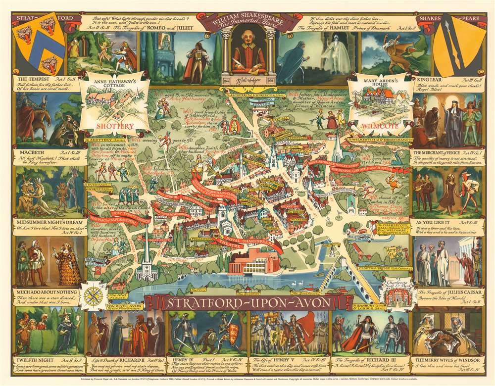
A stunningly vivid and playful 1948 Kerry Lee pictorial map of Stratford-upon-Avon, England. The map looks on the city center from the southeast, across the Avon, with important buildings and Shakespearian locations noted. It is surrounded by 16 images accompanied by quotes drawn from Shakespeare's better-known plays.
Publication History and Census
The map was drawn by Kerry Lee, whose self-portrait, along with an illustration of his dog Jim, appears in the lower right as part of the signature. The map was published c. 1948 by Lee's company, Pictorial Maps Ltd. It was printed in Great Britain by Alabaster Passmore and Sons of London and Maidstone. This is part of a series of pictorial maps, most by Lee, depicting English cities. There are at least two editions, one issued, as here, for the UK market, and another, printed to encourage tourism by the Travel Association of Great Britain and N. Ireland (Tourist Division of the British Tourist and Holidays Board) for the international market.Cartographer
Kerry Ernest Lee (December 4, 1902 - February, 1988) was a British commercial illustrator, artist, and publisher of pictorial maps active in the middle part of the 20th century. Lee was the founder of the London based Pictorial Maps Ltd. He was born in West Ham, Essex, England. Lee's earliest pictorial map work dates to about 1940, when he produced a pictorial map of Scandinavia During World War II, Lee was one of several artist who created dramatic military-educational cut-away images of German aircraft and war maps for the Air Intelligence branch of MI6, A.I.2. After the war, in 1946, he founded Pictorial Maps Ltd. to publish a series of historical and pictorial maps of popular English cities, among them Oxford, Cambridge, London, Stratford-upon-Avon, Birmingham, and Liverpool. He included comic self-portraits illustrating he and his dog Jim in many of the maps. The images proved popular and many were reprinted for sale in the United States by the Travel Association. The firm also employed other artists, including Denis M. Jones. Lee died in Dacorum, Hertfordshire, England. More by this mapmaker...
Condition
Very good.
References
Rumsey 8119.000. OCLC 367390410.