This item has been sold, but you can get on the Waitlist to be notified if another example becomes available, or purchase a digital scan.
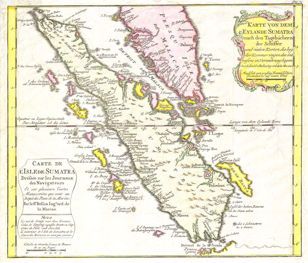
1852 Bellin Map of Sumatra, Malaca, and Singapore
Sumatra-bellin-1750$160.00

Title
Karte von Dem Eylande Sumatra nach den Tagebuchern der Schiffer / Carte de l’Isle de Sumatra Drefsee sur les Journaux des Navigatuers.
1852 10 x 11.5 in (25.4 x 29.21 cm)
1852 10 x 11.5 in (25.4 x 29.21 cm)
Description
This is a beautiful map of the island of Sumatra and the southern tip of the Malaysian Peninsula was produced by the French Cartographer Jacques-Nicolas Bellin in 1852. Depicts the entirety of Sumatra as well as much of modern day Malaysia. Includes the Straights of Singapore (Sincapour). Two decorative title cartouches decorate the map, one in French and one in German. This, the German edition, of is excpetionally rare.
Cartographer
Jacques-Nicolas Bellin (1703 - March 21, 1772) was one of the most important cartographers of the 18th century. With a career spanning some 50 years, Bellin is best understood as geographe de cabinet and transitional mapmaker spanning the gap between 18th and early-19th century cartographic styles. His long career as Hydrographer and Ingénieur Hydrographe at the French Dépôt des cartes et plans de la Marine resulted in hundreds of high quality nautical charts of practically everywhere in the world. A true child of the Enlightenment Era, Bellin's work focuses on function and accuracy tending in the process to be less decorative than the earlier 17th and 18th century cartographic work. Unlike many of his contemporaries, Bellin was always careful to cite his references and his scholarly corpus consists of over 1400 articles on geography prepared for Diderot's Encyclopedie. Bellin, despite his extraordinary success, may not have enjoyed his work, which is described as "long, unpleasant, and hard." In addition to numerous maps and charts published during his lifetime, many of Bellin's maps were updated (or not) and published posthumously. He was succeeded as Ingénieur Hydrographe by his student, also a prolific and influential cartographer, Rigobert Bonne. More by this mapmaker...
Condition
Fine or perfect condition. Original platemark visible. Blank on verso.