This item has been sold, but you can get on the Waitlist to be notified if another example becomes available, or purchase a digital scan.
1760 Bellin Map of Sumatra, Malay and Singapore
Sumatra-bellin-1760$150.00

Title
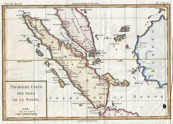
Premiere Carte Des Isles de la Sonde.
1760 (undated) 10 x 14 in (25.4 x 35.56 cm) 1 : 6900000
1760 (undated) 10 x 14 in (25.4 x 35.56 cm) 1 : 6900000
Description
This is a beautiful 1760 map of the island of Sumatra and the southern part of the Malay Peninsula by Jacques-Nicolas Bellin. It covers the entire island of Sumatra, Indonesia, as well as much of modern day Malaysia. Parts of Java and Borneo are also included. The Straits of Malacca (Malaca) and the Straits of Singapore (Sincapura) are finely detailed. The map notes many coastal features, including shoals, banks and small islands. Singapore Island is not specifically named, but it is shown, and several other lesser islands are named including Tioman Island, Banca, and Penang, etc. The cities of Palembang, Jambi, Aceh and Jakarta are located. The map was issued by Bellin as part of Histoire Universelle.
Cartographer
Jacques-Nicolas Bellin (1703 - March 21, 1772) was one of the most important cartographers of the 18th century. With a career spanning some 50 years, Bellin is best understood as geographe de cabinet and transitional mapmaker spanning the gap between 18th and early-19th century cartographic styles. His long career as Hydrographer and Ingénieur Hydrographe at the French Dépôt des cartes et plans de la Marine resulted in hundreds of high quality nautical charts of practically everywhere in the world. A true child of the Enlightenment Era, Bellin's work focuses on function and accuracy tending in the process to be less decorative than the earlier 17th and 18th century cartographic work. Unlike many of his contemporaries, Bellin was always careful to cite his references and his scholarly corpus consists of over 1400 articles on geography prepared for Diderot's Encyclopedie. Bellin, despite his extraordinary success, may not have enjoyed his work, which is described as "long, unpleasant, and hard." In addition to numerous maps and charts published during his lifetime, many of Bellin's maps were updated (or not) and published posthumously. He was succeeded as Ingénieur Hydrographe by his student, also a prolific and influential cartographer, Rigobert Bonne. More by this mapmaker...
Condition
Very good. Minor wear along original fold lines. Original platemark visible. Ink stain in lower right quadrant of the map. Blank on verso.