This item has been sold, but you can get on the Waitlist to be notified if another example becomes available, or purchase a digital scan.
1794 Laurie and Whittle Nautical Chart or Map of the Southern Sumata, Indonesia
SumatraSouth-lauriewhittle-1794$500.00

Title
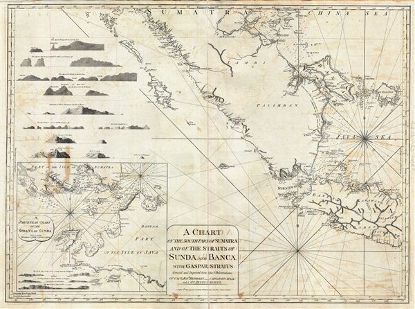
A Chart of the South Part of Sumatra and of the Straits of Sunda and Banca with Gaspar Straits.
1794 (dated) 25 x 34 in (63.5 x 86.36 cm) 1 : 2040000
1794 (dated) 25 x 34 in (63.5 x 86.36 cm) 1 : 2040000
Description
This is a fine example of Laurie and Whittle's 1794 nautical chart or maritime map of Southern Sumatra, Western Java, and the Straits of Sunda and Banca, and the Gaspar Strait. An inset in the lower left offers a more detailed presentation of the Strait of Sunda including numerous depth soundings in fathoms. Numerous land profile views decorate the upper left and the lower left corner of the map. The important map takes in the two primary trading centered in this region, the British East India Company colony at Bencoolen (Fort Marlborough) in western Sumatra, and the Dutch VOC entrepot at Batavia, Java.
This region, always an important trade artery, took on additional significance early in 1794, just before this highly detailed map was issued. The established Dutch and rising English were continually at odds over the region, nevertheless in January of 1794 both temporarily set aside their differences to battle piracy in the Sunda Strait Campaign. The Sunda Strait Campaign is officially considered an extension of French Revolutionary Wars in which French naval vessels operating out of Mauritius, abandoned by their government, turned to piracy and privateering, preying on English and Dutch vessels plying the narrow and vital Straits of Sunda. The French pirates disrupted trade in the region to such an extent that the Dutch and English formed a temporary alliance, presenting a united front and defeating the French pirates in the Battle of Sunda Strait. Ultimately the British took control of Maruitius and both the WIC and VOC actively discouraged subsequent piracy in the strait.
The map offers rich detail including countless depth soundings, notes on the sea floor, commentary on reefs, rhumb lines, shoals, place names and a wealth of other practical information for the mariner. This chart was originally drawn by Jean-Baptiste d'Apres de Mannevillette and later corrected and improved from an English draft. This map was registered by Laurie and Whittle from their offices at 53 Fleet Street, London, on May 12, 1794.
Cartographer
Laurie and Whittle (fl. 1794 - 1858) were London, England, based map and atlas publishers active in the late 18th and early 19th century. Generally considered to be the successors to the Robert Sayer firm, Laurie and Whittle was founded by Robert Laurie (c. 1755 - 1836) and James Whittle (1757-1818). Robert Laurie was a skilled mezzotint engraver and is known to have worked with Robert Sayer on numerous projects. James Whittle was a well-known London socialite and print seller whose Fleet Street shop was a popular haunt for intellectual luminaries. The partnership began taking over the general management of Sayer's firm around 1787; however, they did not alter the Sayer imprint until after Sayer's death in 1794. Apparently Laurie did most of the work in managing the firm and hence his name appeared first in the "Laurie and Whittle" imprint. Together Laurie and Whittle published numerous maps and atlases, often bringing in other important cartographers of the day, including Kitchin, Faden, Jefferys and others to update and modify their existing Sayer plates. Robert Laurie retired in 1812, leaving the day to day management of the firm to his son, Richard Holmes Laurie (1777 - 1858). Under R. H. Laurie and James Whittle, the firm renamed itself "Whittle and Laurie". Whittle himself died six years later in 1818, and thereafter the firm continued under the imprint of "R. H. Laurie". After R. H. Laurie's death the publishing house and its printing stock came under control of Alexander George Findlay, who had long been associated with Laurie and Whittle. Since, Laurie and Whittle has passed through numerous permeations, with part of the firm still extant as an English publisher of maritime or nautical charts, 'Imray, Laurie, Norie and Wilson Ltd.' The firm remains the oldest surviving chart publisher in Europe. More by this mapmaker...
Source
Laurie, R., and Whittle, J., The East-India Pilot, or Oriental Navigator, on One Hundred and Eighteen Plates: Containing a Complete Collection of Charts and Plans, &c., &c. for the Navigation not only of the Indian and China Seas, but of those also between England and the Cape of Good-Hope; Improved and Chiefly Composed from the Last Work of M. D'Apres de Mannevillette; with Considerable Additions, from Private Manuscripts of the Dutch, and from Draughts and Actual Surveys Communicated By Officers of the East-India Company A New Edition, Containing One Hundred and Five Charts. (London: Laurie and Whittle) 1797.
Condition
Very good. Minor wear and verso repair along original centerfold. Original platemark visible. Some offsetting. Some spotting.