This item has been sold, but you can get on the Waitlist to be notified if another example becomes available, or purchase a digital scan.
1937 Sunoco and Rand McNally Pictorial Map of Florida
SunocoFlorida-randmcnally-1937$87.50

Title
Historical Pictorial Points of Interest Map of Florida.
1937 (undated) 20.5 x 21.5 in (52.07 x 54.61 cm) 1 : 1500000
1937 (undated) 20.5 x 21.5 in (52.07 x 54.61 cm) 1 : 1500000
Description
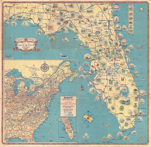
This is a 1937 Sun Oil Company (SUNOCO) and Rand McNally pictorial map of Florida. The map depicts the region from Pensacola Bay to the Atlantic Ocean and from Alabama to Key West. Functioning as both a road map and a tourist map, Florida's history is traced through the vignettes included throughout. Battle sites, forts, natural wonders, and monuments are some of the highlighted locations. Along with these cultural sites, Floridians are illustrated hunting, fishing, playing tennis, and spending time on the beach, portraying the idea that life in Florida is a constant vacation. Cities throughout the state are labeled, including Tallahassee, Gainesville, Tampa, Pensacola, St. Augustine, Orlando, and Miami. Lake Okeechobee, the second-largest fresh water lake in the United States, is prominently featured with a flamingo relaxing in its center. A road map of the eastern United States is inset in the lower left corner, along with a map of the main through routes of Florida.
This map was produced by Rand McNally for the Sun Oil Company and published in 1937.
This map was produced by Rand McNally for the Sun Oil Company and published in 1937.
Cartographer
Rand, McNally and Co. (fl. 1856 - present) is an American publisher of maps, atlases and globes. The company was founded in 1856 when William H. Rand, a native of Quincy, Massachusetts, opened a print shop in Chicago. Rand hired the recent Irish immigrant Andrew McNally to assist in the shop giving him a wage of 9 USD per week. The duo landed several important contracts, including the Tribune's (later renamed the Chicago Tribune) printing operation. In 1872, Rand McNally produced its first map, a railroad guide, using a new cost effective printing technique known as wax process engraving. As Chicago developed as a railway hub, the Rand firm, now incorporated as Rand McNally, began producing a wide array of railroad maps and guides. Over time, the firm expanded into atlases, globes, educational material, and general literature. By embracing the wax engraving process, Rand McNally was able to dominate the map and atlas market, pushing more traditional American lithographic publishers like Colton, Johnson, and Mitchell out of business. Eventually Rand McNally opened an annex office in New York City headed by Caleb S. Hammond, whose name is today synonymous with maps and atlases, and who later started his own map company, C. S. Hammond & Co. Both firms remain in business. More by this mapmaker...
Condition
Good. Wear and toning along original fold lines. Verso reinforcements along most fold lines and at fold intersections. Sunoco Auto Road Map of Florida on verso.
References
OCLC 956381278.