1944 Chapin Map of the Pacific Ocean and Progress in the Pacific War
SuperpowerPacific-chapin-1944$400.00

Title
Superpower in the Pacific.
1944 (dated) 32.75 x 36 in (83.185 x 91.44 cm) 1 : 8870400
1944 (dated) 32.75 x 36 in (83.185 x 91.44 cm) 1 : 8870400
Description
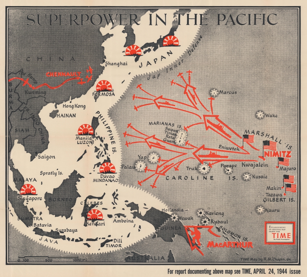
This is a 1944 Robert M. Chapin Jr. map of the then-current situation in the Pacific Theater during World War II (1939 - 1945). It illustrates the 'leapfrogging' tactic by which U.S. Forces crossed the vast Pacific to get within striking distance of Imperial Japan.
A Closer Look
The map depicts from Burma and China to the Gilbert Islands and from Japan to northern Australia. Individual islands and archipelagos are labeled throughout. In the Central and Northern Pacific, the Gilbert Islands, Marshall Islands, and Marianas Islands are identified, as are individual islands (such as Saipan, Tinian, and Guam in the Marianas) and atolls including Kwajalein in the Marshalls, and Tarawa and Makin in the Gilberts. In the Southwest Pacific, larger individual islands are predominantly those identified, for example New Guinea, Celebes, Timor, Borneo, Java, and Sumatra. The Philippine Islands are labeled separately, as are the islands of Mindanao and Luzon, which are within the Philippine Archipelago. Cities, among them Hong Kong, Shanghai, Saigon, Singapore, Manila, Batavia, and Surabaya are labeled.Detailing the War
By late April 1944, when this map was published, the United States had been fighting the Japanese in the Pacific since the attack on Pearl Harbor nearly two and a half years earlier. After a major campaign on Guadalcanal (in the Solomon Islands), the Pacific Theater was divided between General Douglas MacArthur, who commanded forces in the Southwest Pacific, and Admiral Chester Nimitz, who was in command of the Navy's charge across the Central and Northern Pacific. Here, both Nimitz and MacArthur are referenced by name, indicating where their respective forces were located. The third Allied commander identified here is Claire Chennault, who became famous for commanding the American Volunteer Group known as 'The Flying Tigers'. By 1944, Chennault had rejoined the U.S. Army Air Corps and was commanding the 14th U.S. Army Air Force. Chapin also highlights Japanese bases, identifying them with a silhouette of a battleship in front of an illustration of the Japanese Rising Sun, the Japanese insignia widely-used during World War II.Fighting in the Pacific
After realizing the vast distances Allied forces would have to cover in order to reach Japan, the Allies adopted a policy of 'leapfrogging' across the Pacific. Here, Tarawa, Makin, Majuro, Kwajalein, and Eniwetok are colored red, because these were islands that the U.S. Army and U.S. Marine Corps invaded amphibiously. The fighting for these islands was fierce and bloody and set the tone for the rest of the Pacific War. Chapin illustrates the 'leapfrogging' concept by using starbursts, probably meant to symbolize bomb explosions, on islands where Japanese troops were garrisoned, such as Truk and Rabaul, that Allied forces bypassed. Less than two months after this map was published, the Allies launched invasions of Saipan, Tinian, and Guam. By capturing these islands, American bombers were within range of the Japanese Home Islands and began an organized bombing campaigns. Allied forces would also land in the Philippines by the end of the year.Publication History and Census
This map was drawn by Robert M. Chapin Jr. to accompany an article in TIME Magazine that appeared in the April 24, 1944 issue. TIME subsequently published this edition of the map separately. The OCLC records two examples as being part of institutional collections at Franklin and Marshall College in Lancaster, Pennsylvania and at the Osher Map Library at the University of Southern Maine.Cartographer
Robert M. Chapin Jr. (fl. 1933 - 1970) was a prominent architect, cartographer and illustrator active during World War II and the Cold War. Chapin graduated from the University of Pennsylvania in 1933 with a degree in architecture. Since this was the height of the Great Depression, and architects in low demand, he instead took work as a staff cartographer at Newsweek. Catching the attention of Manfred Gottfried of Time, Chapin was offered an accepted a position at the head of Time's cartography department. He remained with Time for some 33 years, from 1937 to 1970, often drawn 2 - 3 new thematic maps weekly. With an architect's gift visualizing information, Chapin became a skilled informational cartographer, heading the cartography department at Time Magazine. Chapin, like Fortune Magazine chief cartographer, Richard Edes Harrison, Chapin was at the forefront of infographic propaganda cartography, a genre that matured during the World War II Era and remains popular today. Working for Time Magazine, Chapin developed a signature style for his long run of 'War Maps.' Chapin was known for his maverick airbrush technique which lead to strong color splashes and intense shading. He also incorporated celluloid stencils to illustrate bomb explosions, flags, sinking ships, and more - generating a instantly recognizable standardized style. Chapin's Time war maps were further distinctive for their use of strong bold reds as a universal symbol of hostility. Chapin graduated from the University of Pennsylvania in 1933 with a degree in architecture. Since this was the height of the Great Depression, an d architects in low demand, he instead took work as a staff cartographer at Newsweek. Catching the attention of Manfred Gottfried of Time, Chapin was offered an accepted a position at the head of Time's cartography department. He remained with Time for some 33 years, from 1937 to 1970, often drawn 2 - 3 new thematic maps weekly. Chapin live in Sharon Connecticut. More by this mapmaker...
Condition
Average. Wear along original fold lines. Verso repairs to fold separations and at fold intersections. Closed tear extending 1.5 inches into printed area from left margin professionally repaired on verso. Closed tear extending 2.25 inches into printed area from right margin professionally repaired on verso. Slight loss at fold intersections and along fold lines. Has old institutional collection stamp on verso. We have contacted the institution to verify that this item was legally deaccessioned.
References
OCLC 320453722.