This item has been sold, but you can get on the Waitlist to be notified if another example becomes available, or purchase a digital scan.
1943 Minneapolis Tribune Map of Norway, Sweden, and Finland in WWII
SwedenFinlandOffensive-owens-1943$115.00

Title
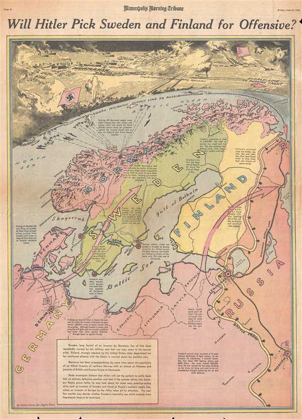
Will Hitler Pick Sweden and Finland for Offensive?
1943 (dated) 22 x 15.5 in (55.88 x 39.37 cm) 1 : 5700000
1943 (dated) 22 x 15.5 in (55.88 x 39.37 cm) 1 : 5700000
Description
This is a Friday, June 25, 1943 Charles Hamilton Owens and Minneapolis Morning Tribune map of Scandinavia. The map depicts the region from the North Sea to Russia and from the Arctic Ocean to eastern Europe. By late June 1943, the summer offensive on the Eastern Front had not yet been decided and speculation was rife as to where the Allies would strike next, following their victory in North Africa. Meant to inform the viewer of one possible sequence of events, the proposed German invasion of Sweden and Finland would open a new front against the Soviets. The possible capture of Murmansk would mean cutting off the importation of American war materiel into the Soviet Union. This would free German naval assets to attack Allied convoys ferrying troops and supplies to North Africa and Britain. The invasion of Sweden and Finland also would severely reduce any advantage the Allies would gain if they were to invade northern Norway, one of the possible points of the next Allied invasion in the summer of 1943. One of the goals of a potential Allied invasion would be to protect Murmansk. All of this speculation would become unimportant by the beginning of July, as the Allies would launch their invasion of Sicily on the ninth. A spectacular drawn view of Murmansk and the Murmansk-Leningrad Railway occupies the top portion of the page, complete with ships importing supplies to the Soviet Union and a train hurtling its way to Leningrad. German and Soviet artillery lob shells at each other from opposite sides of the imagined view.
A Brief History of World War II in Scandinavia until 1943
World War II in Scandinavia is much more nuanced than this map conveys. Sweden's role in the war is complicated, at best. Officially neutral, Sweden had allowed the transit of German troops from Norway to Finland following the German invasion of Norway in April 1940. The Swedes had also been exporting iron ore to both Allied and Axis powers since the war's onset, while maintain their 'neutrality'. Finland, on the other hand, had fought a war against the Soviet Union in 1939-40, known as the Winter War, and was currently fighting alongside the Wehrmacht in what has become known as the Continuation War against the Soviet Union. This partnership blossomed following the German invasion of the Soviet Union in 1941, with the Finns hoping to regain the territory they had lost to the Soviets during the Winter War.
When Charles Hamilton Owens drew this map, he was doubtless inspired by the work of Richard Edes Harrison, an American illustrator and cartographer who, working for Fortune magazine, pioneered a new style of representing the world for WWII era propaganda maps. Edes developed the convention of using spherical perspective with an exaggerated vertical dimension, as on the present map, to illustrate part of the world as part of a greater global situation. This map was drawn by Charles Hamilton Owens and published in the Minneapolis Morning Tribune on Friday, June 25, 1943.
CartographerS
Charles Hamilton Owens (Feb 16, 1881 - March 3, 1958) was an American painter and illustrator and staff illustrator for the Los Angeles Times. Born in San Francisco, he had a passion for drawing from a young age. After landing a job as a messenger for The San Francisco Examiner, Owens began being taught his trade by the newspaper's illustrators. Although it is unclear exactly where Owens started his career as a newspaper staff artist, his reputation was launched by his detailed sketches of the 1906 San Francisco earthquake and fire for a New York paper, using only wire reports and his knowledge of the city. By 1910, Owens was working for the Los Angeles Examiner. Even at this point in his career, Owens was known for experimenting with new forms of illustration, fusing drawings of events with photographs. Owens's map of the Titanic disaster used a high oblique perspective, 'capturing the earth's sphericity and showing the polar regions on a curving horizon.' By the 1920s, Owens reputation as an artist in Los Angeles had grown beyond the realm of journalism. He had a studio and received commissions for landscapes and had exhibited watercolors of California and Hawaii landscapes. Thus, when Owens began creating his war series in April/May 1942, he had all the necessary skills to create visually striking works. The Los Angeles Times began a series of maps for its readers, which were full-page inserts that would appear every Monday and Saturday. Owens's maps would be included in the Monday issues, and a Rand McNally map would be included on Saturdays. The Rand McNally maps, however, were discontinued on June 27, 1942, but Owens's maps continued to be printed. His last war map was published on September 10, 1945, a little over a week after the Japanese surrender. Owens died in Los Angeles on March 3, 1958. More by this mapmaker...
The Minneapolis Tribune (1867 - present) was founded by Colonel William S. King, William D. Washburn, and Dorilus Morrison and the first issue was published on May 25, 1867. In 1941, the Cowles family of Des Moines, Iowa bought the Tribune and merged it with their other holdings in Minneapolis, giving the Cowles family ownership of all the city's major newspapers. The Tribune became the city's morning newspaper, and the Star-Journal was the evening newspaper. The two published a joint Sunday edition. The newspaper is still published today, under the name Star Tribune. Learn More...
Condition
Very good. Newsprint. Closed minor margin tears professionally repaired on verso. Closed tear extending one half inch into printed area professionally repaired on verso. Text on verso.