This item has been sold, but you can get on the Waitlist to be notified if another example becomes available, or purchase a digital scan.
1638 / 1680 Jansson Map of Switzerland
Switzerland-jansson-1638$325.00

Title
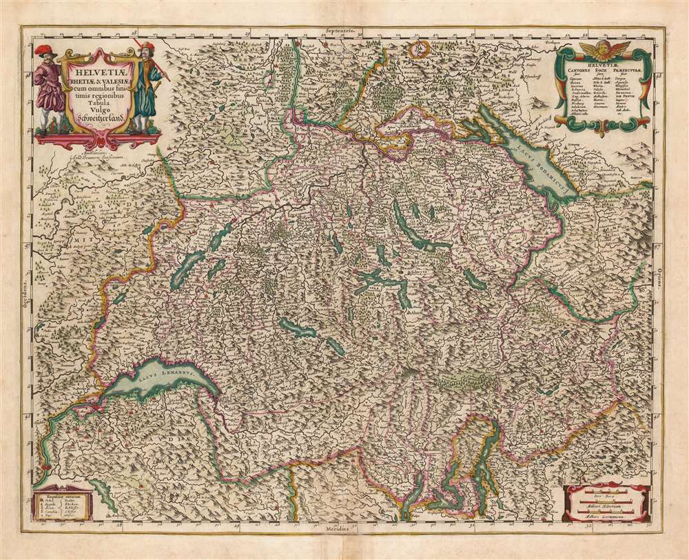
Helvetiae Rhetiae et Valesiae cum omnibus finitimis regionibus Tabula Vulgo Schweitzerland.
1638 (undated) 16.25 x 21 in (41.275 x 53.34 cm) 1 : 800000
1638 (undated) 16.25 x 21 in (41.275 x 53.34 cm) 1 : 800000
Description
This is a beautiful, original-color 1680 example of Jan Jansson's updated map of Switzerland. Neighboring parts of Savoy, Italy, France, and Germany appear as well. The country's lakes and rivers are illustrated with mountainous terrain and forests indicated pictorially. Elegant cartouches provide a key for the symbols used to represent cities, towns, and villages. Distances are given in German and Swiss miles, as well as the distance of travel up to five hours. Cantons, Confederations, and Prefectures are named in the upper right. The title cartouche is flanked by two dashing footsoldiers.
Publication History and Census
This map was engraved for inclusion in Jansson's atlases, first appearing in the Latin edition of 1638. This example, without verso text, corresponds to the 1680, five-volume Jansson Atlas, which lacked text, containing only the maps. We do not see complete examples of this edition in institutional collections. We note ten OCLC listings or the separate map, representing various editions. The map comes to the market from time to time.Cartographer
Jan Jansson or Johannes Janssonius (1588 - 1664) was born in Arnhem, Holland. He was the son of a printer and bookseller and in 1612 married into the cartographically prominent Hondius family. Following his marriage he moved to Amsterdam where he worked as a book publisher. It was not until 1616 that Jansson produced his first maps, most of which were heavily influenced by Blaeu. In the mid 1630s Jansson partnered with his brother-in-law, Henricus Hondius, to produce his important work, the eleven volume Atlas Major. About this time, Jansson's name also begins to appear on Hondius reissues of notable Mercator/Hondius atlases. Jansson's last major work was his issue of the 1646 full edition of Jansson's English Country Maps. Following Jansson's death in 1664 the company was taken over by Jansson's brother-in-law Johannes Waesberger. Waesberger adopted the name of Jansonius and published a new Atlas Contractus in two volumes with Jansson's other son-in-law Elizée Weyerstraet with the imprint 'Joannis Janssonii haeredes' in 1666. These maps also refer to the firm of Janssonius-Waesbergius. The name of Moses Pitt, an English map publisher, was added to the Janssonius-Waesbergius imprint for maps printed in England for use in Pitt's English Atlas. More by this mapmaker...
Source
Jansson, J. Atlas, (Amsterdam), 1680.
Condition
Very good. Centerfold mend at bottom margin. Few filled wormholes with virtually no loss. Fine original hand color.
References
OCLC 1086340948. Van der Krogt, P. C. J., Koeman's Atlantes Neerlandici, 4900:1C.