1588 Munster Map of Switzerland and the Source of the Rhine
Switzerland-munster-1588$300.00

Title
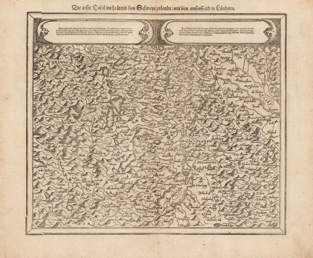
Die erste Tafel innhaltend das Schweytzerlandt/ mit den anstossenden Laendern.
1588 (undated) 12.25 x 14 in (31.115 x 35.56 cm) 1 : 712000
1588 (undated) 12.25 x 14 in (31.115 x 35.56 cm) 1 : 712000
Description
This is Sebastian Münster's map of the northern part of Switzerland and the sources of the Rhine, re-engraved for inclusion in the 1588 edition of his Cosmographey. Among the many cities and towns are Berne, Basel, Konstans, Lucerne, and Friburg.
Münster's Home Front
Of the modern maps included in Münster's opus, this was most informed by the editor's direct experience. The majority of Münster's life was spent living in Basel, and he surveyed the area personally. In fact, this map and the others of the Rhineland were, aside from his modern World map, were the Münster double-page maps to be substantially revised during his lifetime. Thus, when Sebastian Petri ordered new maps to be produced for the 1588 Cosmographey, this was one of the few to be substantially based on Münster's geographical information, rather than copying Ortelius.'Die Erste Tafel'
Munster's Switzerland map was the first of three of his maps covering the full length of the Rhine. In order to more legibly carry the reader along the river's length, this and the other two Rhine maps were oriented to the west. Hence, north is on the right-hand side of the map, and the Lake Constance is shown near the bottom of the map, with Basel above it.Publication History and Census
This map was produced for inclusion in Sebastian Petri's 1588 German edition of Cosmographey, the younger Petri's new edition of Münster's work which remained in publication long after its author's death in 1552. It remained in the book throughout its remaining print run. This example conforms typographically to the 1598 edition. While this individual map is only catalogued once in OCLC, late German editions of Cosmographey are well represented in institutional collections.CartographerS
Sebastian Münster (January 20, 1488 - May 26, 1552), was a German cartographer, cosmographer, Hebrew scholar and humanist. He was born at Ingelheim near Mainz, the son of Andreas Munster. He completed his studies at the Eberhard-Karls-Universität Tübingen in 1518, after which he was appointed to the University of Basel in 1527. As Professor of Hebrew, he edited the Hebrew Bible, accompanied by a Latin translation. In 1540 he published a Latin edition of Ptolemy's Geographia, which presented the ancient cartographer's 2nd century geographical data supplemented systematically with maps of the modern world. This was followed by what can be considered his principal work, the Cosmographia. First issued in 1544, this was the earliest German description of the modern world. It would become the go-to book for any literate layperson who wished to know about anywhere that was further than a day's journey from home. In preparation for his work on Cosmographia, Münster reached out to humanists around Europe and especially within the Holy Roman Empire, enlisting colleagues to provide him with up-to-date maps and views of their countries and cities, with the result that the book contains a disproportionate number of maps providing the first modern depictions of the areas they depict. Münster, as a religious man, was not producing a travel guide. Just as his work in ancient languages was intended to provide his students with as direct a connection as possible to scriptural revelation, his object in producing Cosmographia was to provide the reader with a description of all of creation: a further means of gaining revelation. The book, unsurprisingly, proved popular and was reissued in numerous editions and languages including Latin, French, Italian, and Czech. The last German edition was published in 1628, long after Münster's death of the plague in 1552. Cosmographia was one of the most successful and popular books of the 16th century, passing through 24 editions between 1544 and 1628. This success was due in part to its fascinating woodcuts (some by Hans Holbein the Younger, Urs Graf, Hans Rudolph Manuel Deutsch, and David Kandel). Münster's work was highly influential in reviving classical geography in 16th century Europe, and providing the intellectual foundations for the production of later compilations of cartographic work, such as Ortelius' Theatrum Orbis Terrarum Münster's output includes a small format 1536 map of Europe; the 1532 Grynaeus map of the world is also attributed to him. His non-geographical output includes Dictionarium trilingue in Latin, Greek, and Hebrew, and his 1537 Hebrew Gospel of Matthew. Most of Munster's work was published by his stepson, Heinrich Petri (Henricus Petrus), and his son Sebastian Henric Petri. More by this mapmaker...
Heinrich Petri (1508 - 1579) and his son Sebastian Henric Petri (1545 – 1627) were printers based in Basel, Switzerland. Heinrich was the son of the printer Adam Petri and Anna Selber. After Adam died in 1527, Anna married the humanist and geographer Sebastian Münster - one of Adam's collaborators. Sebastian contracted his stepson, Henricus Petri (Petrus), to print editions of his wildly popular Cosmographia. Later Petri, brought his son, Sebastian Henric Petri, into the family business. Their firm was known as the Officina Henricpetrina. In addition to the Cosmographia, they also published a number of other seminal works including the 1566 second edition of Nicolaus Copernicus's De Revolutionibus Orbium Coelestium and Georg Joachim Rheticus's Narratio. Learn More...
Source
Munster, S., Cosmographey, (Basel: Petri) 1598.
Condition
Very good condition. Printer's crease to lower left. Light toning, else excellent.
References
OCLC 163162932 McLean, Matthew The Cosmographia of Sebastian Munster: Describing the World in the Reformation (Ashgate, 2007). Ruland, Harold L. 'A Survey of the Double-page Maps in Thirty-Five Editions of the Comographia (sic) Universalis 1544-1628 of Sebastian Munster and in his Editions of Ptolemy's Geographia 1540-1552' in Imago Mundi XVI 1962.